

Resistivity Calibration Instrument Geophysical Resistivity Sensor Array Resistivity Data Logger


Related Products
-
 Mineral Exploration Data Interpretation Geophysical Prospecting Consulting Service Underground Cavity Detection SystemNegotiableMOQ: 1 Set
 -
Multi Functional Pipe Inspection Camera Wireless Drain Inspection Camera Monitor High Pressure Waterproof Borehole CameraNegotiableMOQ: 1 Set
-
Resistivity Cable Testing System Time Domain IP Measurement SystemNegotiableMOQ: 1 Set
-
Passive Source Seismic Sensor Borehole Seismic Sensor Node Seismic Sensor for Dam MonitoringUS$ 500MOQ: 1 Set
-
ARM FPGA Data Acquisition System Remote Reference MT Station IP Resistivity Imaging EquipmentNegotiableMOQ: 1 Set
The Foundational Toolkit for Cross-Disciplinary Subsurface Intelligence
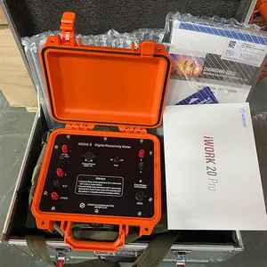
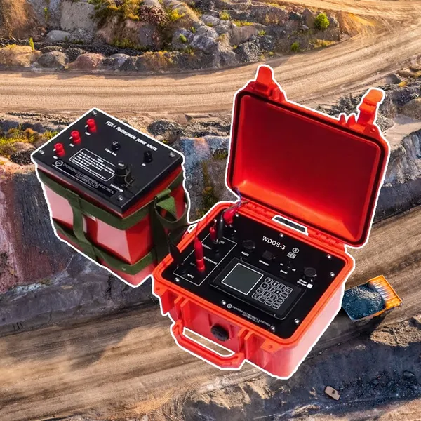
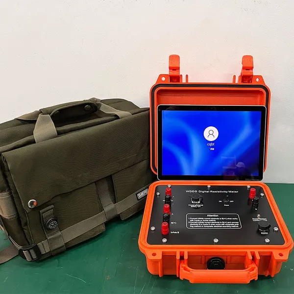
The true mark of a transformative technology lies not merely in its performance within a single domain, but in its capacity to serve as a universal methodological core for a constellation of disparate disciplines. The WDDS-3C Digital Resistivity Meter embodies this principle as a fundamental toolkit for subsurface intelligence, whose foundational principles of electrical resistivity imaging provide a common language and a reliable data stream for fields as varied as civil engineering, archaeology, agriculture, and environmental forensics. This instrument transcends categorization as a specialized geophysical device; it is more accurately understood as a versatile spatial data acquisition platform that renders the opaque subsurface into a quantifiable, mappable, and interpretable dimension. Its value is multiplied by its inherent adaptability, allowing experts from different fields to apply the same robust physical principle to answer uniquely different questions about what lies beneath, thereby fostering a new era of data-driven, cross-disciplinary problem-solving grounded in empirical subsurface evidence.
At its heart, the system’s universality is derived from the direct correlation between electrical resistivity and a suite of critical physical properties—moisture content, porosity, fluid chemistry, and lithology. This correlation is not an artifact of a single application but a fundamental relationship in the natural world. For the geotechnical engineer, a resistivity map translates to a model of soil compaction and bedrock integrity for foundation design. For the hydrologist, the identical data stream reveals aquifer geometry and groundwater saturation. For the archaeologist, subtle resistivity contrasts outline the footprints of ancient walls and burial pits. For the farmer, the variations map root-zone moisture stress and soil texture. Thus, the WDDS-3C does not provide a single answer; it provides a high-fidelity map of a fundamental material property, which becomes the objective substrate upon which domain-specific knowledge and interpretation are applied. This makes it an unparalleled tool for integrated projects, such as assessing the archaeological sensitivity of a site prior to construction or evaluating the hydrological impact of a new agricultural practice, ensuring all stakeholders operate from a single, verifiable truth about the ground.
This cross-disciplinary utility is operationalized through the system’s modular and software-driven configurability. A pre-configured survey mode for utility detection, a custom electrode array for glacier basal imaging, and a high-resolution grid for forensic search are not different instruments but different expressions of the same core technology. The system’s software ecosystem is designed to facilitate this, with application-specific wizards, data processing presets, and export templates tailored for outputs needed by GIS platforms, CAD/BIM software, agricultural management systems, and archaeological databases. This design philosophy ensures that a field operator, whether a geologist, an environmental technician, or a research student, can efficiently collect publication-grade or decision-ready data without being a master geophysicist. The instrument’s rugged, field-agnostic design—resistant to dust, moisture, and temperature extremes—further ensures this core capability is deliverable in a desert for mining prospecting, a muddy field for drainage assessment, or a protected forest for ecological surveying, with equal reliability.
Ultimately, investing in the WDDS-3C is an investment in future-proof subsurface literacy. It equips an organization—be it a university department, an engineering consultancy, a government agency, or an NGO—with the capacity to interrogate the ground for a vast array of purposes over the long term. The data it generates forms a persistent, digital asset that can be re-interpreted as scientific understanding evolves or as new questions arise. In a world where challenges are increasingly interdisciplinary—where climate adaptation, sustainable resource use, and infrastructure resilience intersect—the ability to rapidly and reliably characterize the shallow subsurface is a foundational competency. The WDDS-3C provides this competency not as a black-box solution, but as an open, adaptable, and profoundly capable platform that empowers experts across the spectrum to see the unseen, making informed decisions based on a deep, shared understanding of our planetary substrate.
Technical Specifications: The Core Platform for Multi-Disciplinary Application
| Parameter | Specification & Cross-Disciplinary Relevance |
|---|---|
| Core Measurement | Electrical Resistivity (& Induced Polarization). The universal physical property proxy for moisture, porosity, lithology, and fluid chemistry. |
| Data Output | 2D Profiles, 3D Volumetric Models, and Georeferenced Depth Slices. Compatible base maps for GIS in any field (Engineering, Environmental, Archaeological, Agricultural). |
| Configurable Survey Modes | Pre-set and user-definable protocols for Profiling, Sounding, Grid Mapping, and Time-Lapse Monitoring. Adapts to linear (utility corridor), deep (mineral target), or detailed (archaeological site) investigations. |
| Software & Export Flexibility | Dedicated acquisition software with modules/plugins for different disciplines. Exports to .DXF (CAD), shapefiles (GIS), .csv (data analysis), and specialized formats (e.g., for agricultural management software). |
| Depth of Investigation Range | Adjustable from |
| Spatial Resolution | Scalable with electrode spacing. From decimeter-scale for utility/archaeology to meter-scale for regional geology. |
| Operational Robustness | IP54 enclosure, -10°C to +50°C operational range. Ensures reliable deployment in diverse global environments, from urban sites to remote field camps. |
| Power & Logistics | Internal battery (12+ hrs) and external 12V input. Supports sustained use anywhere, independent of grid power. Portable for single-operator use in constrained spaces. |
| Key Universal Strengths | Non-Invasiveness: Allows investigation without digging or drilling. Spatial Continuity: Provides data between discrete sample points (boreholes, test pits). Temporal Monitoring: Capable of 4D studies to track changes over time. |

Send Inquiry to This Supplier


You May Also Like
-
4-20mA Water Level Transmitter Sewage Level Sensor Liquid Level SwitchNegotiableMOQ: 1 Piece
-
SP Measurement System VES Resistivity Survey KitNegotiableMOQ: 1 Set
-
Seismic Impact System Geotechnical Seismic Source Surface Wave Seismic SourceUS$ 500MOQ: 1 Set
-
Geomagnetic Field Instrument High Speed Magnetometer Magnetic Field SensorNegotiableMOQ: 1 Set
-
Portable Logging Winch 3000m Logging Winch Borehole Downhole Logging WinchNegotiableMOQ: 1 Piece
-
Sewer Crawler Camera Price High Temp Borehole CameraNegotiableMOQ: 1 Set
-
Hydrostatic Level Sensor for Closed Tank Slurry Level Measurement SensorNegotiableMOQ: 1 Piece
-
Spectral IP Resistivity Imaging System Dual Mode IP/Resistivity SystemNegotiableMOQ: 1 Set
-
24 Channel Geophone Cable for MASW Mueller Takeout Seismic WireNegotiableMOQ: 1 Set
-
Marine Electromagnetic Receiver Geophysical Data Acquisition SystemNegotiableMOQ: 1 Set
