

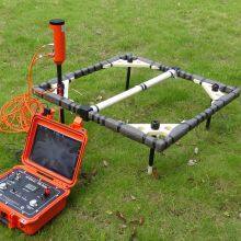
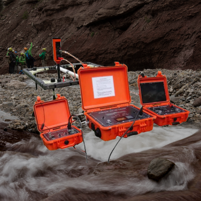
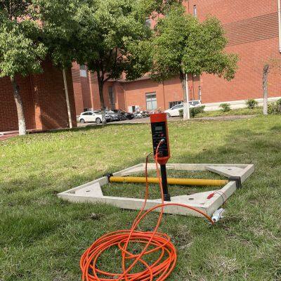
Marine Electromagnetic Receiver Geophysical Data Acquisition System


Related Products
-
 Deep Water Well Inspection Camera Underground Underwater Borehole Inspection CameraUS$ 1 - 1MOQ: 1 Piece
 -
360 Degree Rotation Underwater Deep Water Well Inspection CameraUS$ 1 - 1MOQ: 1 Piece
-
Waterproof Underwater Manhole and Borehole Inspection CameraUS$ 1 - 1MOQ: 1 Piece
-
Borehole Water Well Inspection CCTV Camera Well LoggerNegotiableMOQ: 1 Piece
-
Resistivity Calibration Instrument Geophysical Resistivity Sensor Array Resistivity Data LoggerNegotiableMOQ: 1 Set
WTEM-3: A Unified Platform Transforming Geophysical Data into Strategic Business and Engineering Outcomes
In an era where data abundance often overwhelms rather than informs, the true value of geophysical investigation lies not in the volume of measurements collected, but in the clarity, reliability, and actionable nature of the insights derived. The WTEM-3 System has been conceived and engineered as a comprehensive subsurface intelligence ecosystem, designed to guide stakeholders through the entire journey from raw field acquisition to strategic decision-making. It is not merely an instrument that records electromagnetic responses; it is a fully integrated platform that synthesizes acquisition, processing, interpretation, visualization, and collaboration into a seamless workflow. By eliminating the traditional fragmentation between these stages—where data often languishes in proprietary formats, interpretation is decoupled from field realities, and results fail to reach decision-makers in a timely or accessible manner—the WTEM-3 fundamentally redefines the value proposition of geophysics. It transforms a technical service into a strategic asset, empowering exploration managers, civil engineers, environmental consultants, and government agencies to make faster, more confident, and ultimately more profitable decisions based on a holistic, verifiable, and dynamically accessible understanding of the subsurface.
End-to-End Workflow Integration from Sensor to Shareholder is the foundational principle of this ecosystem. From the moment the first measurement is triggered, the WTEM-3 creates a continuous, unbroken digital thread linking every piece of raw data to every final deliverable. Field acquisition is guided by intelligent, context-aware workflows that adapt to real-time conditions, ensuring optimal data quality without requiring expert intervention at every step. As data flows into the processing engine, it is not merely inverted but interpreted in parallel using a library of geological, hydrogeological, and geotechnical models. This integrated processing environment eliminates the costly and error-prone cycle of exporting data between disparate software packages, where assumptions can be lost and metadata corrupted. The result is a single-source-of-truth digital model that retains full provenance—every interpreted feature can be traced back directly to the raw field measurements that support it. This unbroken chain of custody is not merely a technical convenience; it is the foundation of defensible reporting under international codes, legally admissible evidence for litigation, and the bedrock of stakeholder confidence in high-stakes investment decisions.
Collaborative Intelligence and Role-Based Access transforms how geophysical information is consumed across an organization. Recognizing that a project geophysicist, a civil engineer, a financial analyst, and a community relations officer require fundamentally different views of the same underlying data, the WTEM-3 platform incorporates a role-based access and visualization layer. The geophysicist accesses the full inversion parameter space, fine-tuning models and conducting sensitivity analyses. The engineer views the data through the lens of geotechnical parameter maps, with outputs formatted for direct import into design software. The financial analyst receives investment-grade summary reports with clear probabilistic statements of resource potential and risk. The community liaison works with intuitive, photorealistic 3D visualizations and animated fly-throughs that make complex technical concepts accessible to a non-specialist audience. All these stakeholders are working from the same validated, time-stamped dataset, ensuring that discussions, decisions, and communications are grounded in a shared reality. This democratization of subsurface intelligence breaks down the silos that traditionally separate technical experts from decision-makers, aligning teams around a common understanding and dramatically accelerating the path from data to consensus.
Predictive Analytics and Decision Support Tools elevate the platform beyond descriptive modeling into the realm of prescriptive intelligence. The WTEM-3 ecosystem incorporates a suite of embedded predictive tools that leverage the richness of its 3D models to answer forward-looking questions. For a mining client, it can take the geophysical model of an ore body and run thousands of stochastic simulations of mining scenarios, generating probability distributions for net present value, payback period, and risk exposure based on the inherent uncertainty in the resource model. For an infrastructure project, it can feed its 3D ground model into finite element analysis engines to predict settlement patterns under various loading conditions, allowing engineers to optimize foundation designs before a single cubic meter of earth is moved. For a water management agency, it can integrate its aquifer models with climate projections to forecast sustainable yield under different drought scenarios. These predictive capabilities transform the WTEM-3 from a tool that answers “what is there?” into a strategic decision support system that helps answer “what should we do next?” and “what are the likely outcomes of our choices?”—the questions that ultimately determine the success or failure of any major subsurface-dependent venture.
Subsurface Intelligence Ecosystem Specifications
| Ecosystem Component | WTEM-3 Implementation & Capability | Traditional Fragmented Workflow | Strategic Value Proposition |
|---|---|---|---|
| End-to-End Digital Thread | Unified software environment from acquisition to final model; full metadata and provenance tracking. | Data passed between multiple software packages; information and assumptions lost in translation. | Ensures defensibility and reproducibility; every interpreted result is auditable back to raw field data. |
| Role-Based Visualization & Access | Tailored interfaces and outputs for geophysicists, engineers, executives, and community stakeholders. | Technical reports that are inaccessible to non-specialists; communication gaps between teams. | Aligns all stakeholders around a shared reality, accelerating consensus and reducing miscommunication-driven delays. |
| Embedded Predictive Analytics | Stochastic modeling, scenario simulation, and integration with external engineering/financial models. | Geophysical results are descriptive; subsequent analysis requires manual data transfer and re-interpretation. | Transforms geophysics from a cost center into a value driver, providing direct inputs to business and engineering decisions. |
| Real-Time Collaboration Hub | Cloud-based project workspace with live data streaming, annotation tools, and version control. | Data shared via email or physical media; version control and collaborative review are cumbersome. | Enables geographically distributed teams to work as a single unit, dramatically accelerating project cycles. |
| Dynamic Reporting & Deliverable Generation | Automated, template-driven report generation with embedded interactive 3D models and animations. | Report creation is a manual, time-consuming process; static figures limit stakeholder engagement. | Reduces reporting time from weeks to hours while creating compelling, accessible narratives that build confidence and support. |
| Open API & Third-Party Integration | Published application programming interface (API) for custom workflows; native integration with major engineering, mining, and GIS platforms. | Geophysical data exists in a silo, requiring complex and often lossy export to other systems. | Seamlessly integrates geophysical intelligence into the broader enterprise software ecosystem, enabling true digital twin workflows. |

Send Inquiry to This Supplier


You May Also Like
-
Mineral Exploration Data Interpretation Geophysical Prospecting Consulting Service Underground Cavity Detection SystemNegotiableMOQ: 1 Set
-
Multi Functional Pipe Inspection Camera Wireless Drain Inspection Camera Monitor High Pressure Waterproof Borehole CameraUS$ 5000MOQ: 1 Set
-
Resistivity Cable Testing System Time Domain IP Measurement SystemNegotiableMOQ: 1 Set
-
Passive Source Seismic Sensor Borehole Seismic Sensor Node Seismic Sensor for Dam MonitoringUS$ 500MOQ: 1 Set
-
ARM FPGA Data Acquisition System Remote Reference MT Station IP Resistivity Imaging EquipmentNegotiableMOQ: 1 Set
-
4-20mA Water Level Transmitter Sewage Level Sensor Liquid Level SwitchNegotiableMOQ: 1 Piece
-
SP Measurement System VES Resistivity Survey KitNegotiableMOQ: 1 Set
-
Seismic Impact System Geotechnical Seismic Source Surface Wave Seismic SourceUS$ 500MOQ: 1 Set
-
Geomagnetic Field Instrument High Speed Magnetometer Magnetic Field SensorNegotiableMOQ: 1 Set
-
Portable Logging Winch 3000m Logging Winch Borehole Downhole Logging WinchNegotiableMOQ: 1 Piece
