

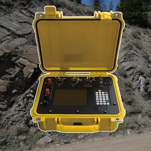
ARM FPGA Data Acquisition System Remote Reference MT Station IP Resistivity Imaging Equipment


Related Products
-
 4-20mA Water Level Transmitter Sewage Level Sensor Liquid Level SwitchNegotiableMOQ: 1 Piece
 -
SP Measurement System VES Resistivity Survey KitNegotiableMOQ: 1 Set
-
Seismic Impact System Geotechnical Seismic Source Surface Wave Seismic SourceUS$ 500MOQ: 1 Set
-
Geomagnetic Field Instrument High Speed Magnetometer Magnetic Field SensorNegotiableMOQ: 1 Set
-
Portable Logging Winch 3000m Logging Winch Borehole Downhole Logging WinchNegotiableMOQ: 1 Piece
GD-5 Magnetotelluric System: Accelerating the Journey from Question to Answer
In the competitive landscapes of resource exploration and project development, time is often the most critical variable. The GD-5 Magnetotelluric System functions as a powerful time compression engine, systematically collapsing the intervals between asking geological questions and receiving definitive answers. It achieves this acceleration through integrated workflow design, eliminating the sequential delays that traditionally separate data acquisition, processing, interpretation, and decision-making. For organizations operating in fast-moving markets or under tight project deadlines, the GD-5 provides the competitive advantage of speed without compromising the quality or reliability of subsurface intelligence.
The acceleration begins at the most fundamental level: getting data into the ground. The GD-5's lightweight, modular design and intuitive setup procedures reduce station establishment time to minutes rather than hours. Its efficient power consumption eliminates the need for generator logistics and refueling stops. Its robust IP67 construction means surveys continue through weather conditions that would halt operations with lesser equipment. These factors combine to dramatically increase daily data acquisition rates, allowing projects to cover more ground in less time and at lower cost. A survey that might require weeks with conventional systems can often be completed in days with the GD-5.
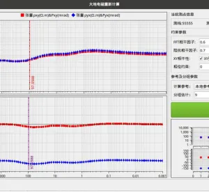
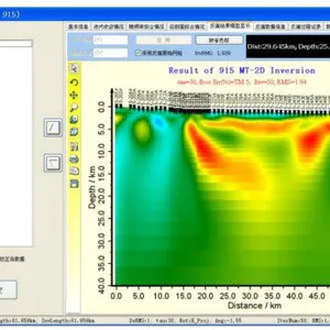
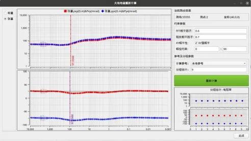
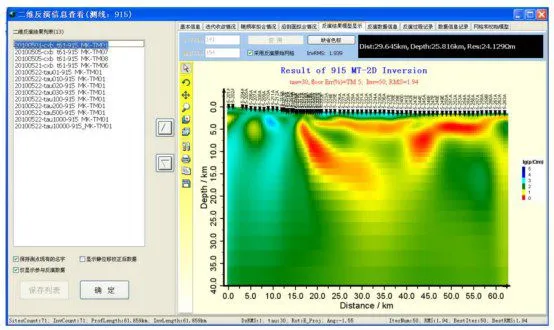
The most significant time compression, however, occurs in the transition from data to insight. Traditional workflows create a sequential bottleneck: data is collected, stored, physically transported, processed in batch, and finally interpreted weeks or months later. The GD-5's onboard processing and real-time quality control eliminate this sequential model entirely. Preliminary results emerge during acquisition, allowing interpreters to begin their work while the field crew is still operating. Anomalies are identified immediately, enabling real-time decisions about survey adjustments rather than waiting for post-processing to reveal missed opportunities. The traditional post-survey processing phase is compressed from weeks to days, or even hours, because much of the work has already been done in the field.
| Time-Critical Phase | GD-5 Acceleration Feature | Timeline Impact |
|---|---|---|
| Mobilization & Setup | Sub-30 minute station establishment; lightweight components. | 50-70% reduction in daily setup time, allowing more stations per day and shorter overall programs. |
| Data Acquisition | High-speed sampling; continuous recording; automated quality control. | Doubles effective data collection rate through elimination of rework and weather-related downtime. |
| Processing & QC | Onboard real-time processing; immediate quality feedback. | Eliminates post-survey processing queue; results available during field operations, not weeks later. |
| Interpretation | Preliminary models generated in field; seamless export to inversion software. | Enables parallel interpretation concurrent with acquisition, collapsing traditional sequential workflow. |
| Decision-Making | Rapid availability of final products; confidence through documented quality. | Reduces time from survey completion to drill decision by 60-80%, accelerating project advancement. |
The strategic implications of this time compression extend throughout the organization. In exploration, faster surveys and faster interpretation mean earlier identification of drilling targets, potentially beating competitors to the most prospective ground. In engineering, rapid subsurface characterization enables accelerated project permitting and earlier construction starts, improving project economics through reduced carrying costs. In environmental monitoring, real-time data availability allows for immediate response to changing conditions, enhancing protection of sensitive resources. The GD-5 does not simply make surveys faster; it fundamentally restructures the relationship between investigation and action, enabling decisions that were previously constrained by long information cycles to be made with unprecedented speed and confidence. It is the essential tool for organizations that recognize that in the race to discovery and development, speed is not just convenience—it is competitive advantage.

Send Inquiry to This Supplier

You May Also Like
-
Sewer Crawler Camera Price High Temp Borehole CameraNegotiableMOQ: 1 Set
-
Hydrostatic Level Sensor for Closed Tank Slurry Level Measurement SensorNegotiableMOQ: 1 Piece
-
Spectral IP Resistivity Imaging System Dual Mode IP/Resistivity SystemNegotiableMOQ: 1 Set
-
24 Channel Geophone Cable for MASW Mueller Takeout Seismic WireNegotiableMOQ: 1 Set
-
Marine Electromagnetic Receiver Geophysical Data Acquisition SystemNegotiableMOQ: 1 Set
-
Coring Wireline Cable Wireline Logging Tool CableNegotiableMOQ: 1 Piece
-
Rotary Head Borehole Camera Sewer Crawler Camera PriceNegotiableMOQ: 1 Set
-
Borehole Water Level Data Logger Radar Level Measurement Hydroponic Water Level ControllerNegotiableMOQ: 1 Piece
-
Tunnel Geological Prediction System Aquifer Characterization InstrumentNegotiableMOQ: 1 Set
-
Geophone for Seismic Survey Seismic Sensor for Sale 4.5 Hz Geophone SensorNegotiableMOQ: 1 Set
