

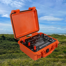
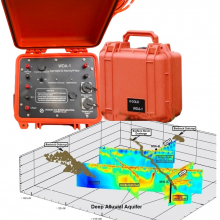
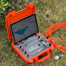
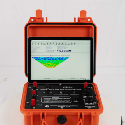
Spectral IP Resistivity Imaging System Dual Mode IP/Resistivity System


Related Products
-
 24 Channel Geophone Cable for MASW Mueller Takeout Seismic WireNegotiableMOQ: 1 Set
 -
Marine Electromagnetic Receiver Geophysical Data Acquisition SystemNegotiableMOQ: 1 Set
-
Deep Water Well Inspection Camera Underground Underwater Borehole Inspection CameraUS$ 1 - 1MOQ: 1 Piece
-
360 Degree Rotation Underwater Deep Water Well Inspection CameraUS$ 1 - 1MOQ: 1 Piece
-
Waterproof Underwater Manhole and Borehole Inspection CameraUS$ 1 - 1MOQ: 1 Piece
The Community Resilience and Adaptive Groundwater Stewardship Platform
In an era defined by accelerating climate variability, population growth, and intensifying competition for finite water resources, the imperative to manage groundwater sustainably has transcended technical challenge to become a fundamental pillar of community resilience and intergenerational equity. Conventional approaches to hydrogeological investigation, while valuable for site-specific assessments, often fail to provide the integrated, forward-looking intelligence necessary for communities, watershed managers, and policymakers to navigate the complex trade-offs inherent in long-term water resource stewardship. Our Community Resilience and Adaptive Groundwater Stewardship Platform represents a fundamental reconceptualization of how subsurface information is acquired, interpreted, and deployed in service of societal well-being. It is not merely a geophysical instrument but a comprehensive decision-support ecosystem designed to empower stakeholders with the holistic understanding, predictive foresight, and collaborative tools necessary to safeguard their groundwater heritage for generations to come.
The platform's foundational innovation lies in its participatory sensing architecture, which deliberately integrates professional-grade geophysical investigation with community-based monitoring networks. Recognizing that sustainable management requires both scientific rigor and local knowledge, the platform provides a tiered sensing framework that accommodates data from multiple sources with varying levels of precision. Professional surveys conducted with advanced resistivity and electromagnetic imaging systems establish high-resolution baseline characterization of aquifer architecture, recharge zones, and vulnerable boundaries. These authoritative datasets are then augmented by data from community-installed sensor networks—simplified, low-cost monitoring nodes deployed in existing wells by local water users, schools, or citizen science groups. These nodes measure water levels and basic quality parameters, transmitting observations via cellular or mesh networks to the platform's central data aggregation engine. This synergistic data ecosystem combines the depth and accuracy of professional geophysics with the spatial density and temporal continuity achievable only through broad community participation, creating a living watershed observatory that is both scientifically defensible and socially embedded.
The platform's analytical core is its participatory modeling and scenario exploration environment, which translates complex hydrogeological data into intuitive, accessible formats that empower diverse stakeholders to engage meaningfully in water resource decisions. Through interactive web-based interfaces, users can explore visualizations of the underlying aquifer system—its geometry, flow patterns, and vulnerability to drought or contamination—rendered in three dimensions with clear, non-technical annotations. More powerfully, the platform enables users to pose "what-if" questions that are instantly translated into scientifically rigorous simulations: "What would happen to our town's water supply if this new development proceeds?" or "How would a five-year drought affect water levels in the wells my family depends on?" The underlying coupled surface-water/groundwater models, calibrated to the integrated sensing data, compute probabilistic answers that are presented with clear visualizations of uncertainty and confidence. This democratization of predictive modeling transforms water management from a technocratic exercise conducted by specialists into a transparent, inclusive process in which all affected parties can explore consequences, test assumptions, and develop shared understanding.
Crucially, the platform incorporates a structured deliberation and decision-capture module designed to support collaborative governance processes. When communities convene to make consequential water management decisions—whether to approve a new well field, establish conservation districts, or invest in aquifer recharge infrastructure—the platform provides a facilitated decision-support workspace. Stakeholders can collectively explore the implications of proposed actions using the platform's simulation tools, with all assumptions, model runs, and deliberations systematically logged. When consensus is reached, the platform generates formal decision records that document the scientific basis for the choice, the alternatives considered, and the anticipated outcomes. These records serve multiple purposes: they provide transparency for regulatory compliance, establish an auditable trail for legal defensibility, and—most importantly—create an institutional memory that preserves the reasoning behind critical decisions for future generations of community leaders who will inherit the consequences.
Community Stewardship Platform: Participatory and Analytical Specifications
| Platform Component | Core Functionality | Participatory Feature | Resilience Outcome |
|---|---|---|---|
| Professional Sensing Suite | High-resolution resistivity/EM imaging for baseline characterization | Survey results translated into community-accessible 3D visualizations with plain-language explanations | Establishes authoritative scientific foundation for all subsequent management decisions |
| Community Sensor Network | Simplified water level/quality nodes deployable by local stakeholders | Data visible in real-time on public dashboards; alerts for significant changes trigger community notifications | Builds widespread awareness of aquifer conditions and early warning of emerging threats |
| Participatory Modeling Environment | Web-based interface for exploring scenarios and testing management options | "What-if" questions answered through accessible simulations; uncertainty clearly communicated | Empowers all stakeholders to engage meaningfully in decisions affecting their water future |
| Decision-Capture Module | Structured logging of deliberations, model runs, and consensus agreements | Formal decision records accessible to all community members; searchable by topic, date, or decision-maker | Creates transparent, auditable institutional memory that preserves rationale for future generations |
| Youth Education Portal | Curriculum-aligned educational modules exploring local hydrogeology | Interactive games, virtual field trips, and citizen science projects for K-12 students | Cultivates next-generation water stewards with deep understanding of their local groundwater systems |
The platform's commitment to intergenerational equity is embodied in its youth education and legacy engagement portal. Recognizing that true sustainability requires not only wise decisions today but also a citizenry equipped to make wise decisions tomorrow, the platform includes a comprehensive suite of educational modules aligned with K-12 science curricula. Students can explore their local aquifer system through interactive games that simulate water balance, virtual field trips that follow a raindrop from land surface to well, and simplified citizen science projects that contribute real observations to the community monitoring network. High school students can engage with the professional modeling tools under guided curricula, conducting original research on topics such as the impact of land use change on recharge or the vulnerability of different aquifer zones to contamination. This intentional cultivation of hydrogeological literacy ensures that each generation inherits not only the physical aquifer but also the knowledge, skills, and institutional frameworks necessary to steward it wisely.
Designed for watershed districts, community water systems, tribal nations, and regional planning authorities, the platform is supported by a dedicated community science facilitation team that provides training, technical support, and facilitated engagement services. This team helps communities navigate the initial setup, train local sensor network coordinators, design participatory modeling workshops tailored to local decision contexts, and integrate platform outputs into formal planning and regulatory processes. The platform thus serves not merely as a technological tool but as a catalyst for collaborative governance, building the social infrastructure necessary to complement its technical infrastructure.
In summary, the Community Resilience and Adaptive Groundwater Stewardship Platform represents a fundamental evolution in the relationship between technology and society. It transforms geophysical investigation from a specialized technical service into a shared community asset, empowering diverse stakeholders to co-create the knowledge necessary for wise water stewardship. By integrating professional science with community observation, participatory modeling with transparent decision-making, and current management with future education, it provides the holistic, intergenerational framework essential for building true resilience in the face of mounting water challenges. It is, ultimately, a platform not just for seeing beneath the ground, but for seeing into the future we wish to create together.

Send Inquiry to This Supplier


You May Also Like
-
Borehole Water Well Inspection CCTV Camera Well LoggerNegotiableMOQ: 1 Piece
-
Resistivity Calibration Instrument Geophysical Resistivity Sensor Array Resistivity Data LoggerNegotiableMOQ: 1 Set
-
Mineral Exploration Data Interpretation Geophysical Prospecting Consulting Service Underground Cavity Detection SystemNegotiableMOQ: 1 Set
-
Multi Functional Pipe Inspection Camera Wireless Drain Inspection Camera Monitor High Pressure Waterproof Borehole CameraUS$ 5000MOQ: 1 Set
-
Resistivity Cable Testing System Time Domain IP Measurement SystemNegotiableMOQ: 1 Set
-
Passive Source Seismic Sensor Borehole Seismic Sensor Node Seismic Sensor for Dam MonitoringUS$ 500MOQ: 1 Set
-
ARM FPGA Data Acquisition System Remote Reference MT Station IP Resistivity Imaging EquipmentNegotiableMOQ: 1 Set
-
4-20mA Water Level Transmitter Sewage Level Sensor Liquid Level SwitchNegotiableMOQ: 1 Piece
-
SP Measurement System VES Resistivity Survey KitNegotiableMOQ: 1 Set
-
Seismic Impact System Geotechnical Seismic Source Surface Wave Seismic SourceUS$ 500MOQ: 1 Set
