

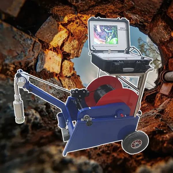
Sewer Crawler Camera Price High Temp Borehole Camera


Related Products
-
 Hydrostatic Level Sensor for Closed Tank Slurry Level Measurement SensorNegotiableMOQ: 1 Piece
 -
Spectral IP Resistivity Imaging System Dual Mode IP/Resistivity SystemNegotiableMOQ: 1 Set
-
24 Channel Geophone Cable for MASW Mueller Takeout Seismic WireNegotiableMOQ: 1 Set
-
Marine Electromagnetic Receiver Geophysical Data Acquisition SystemNegotiableMOQ: 1 Set
-
Coring Wireline Cable Wireline Logging Tool CableNegotiableMOQ: 1 Piece
The Digital Transformation Enabler
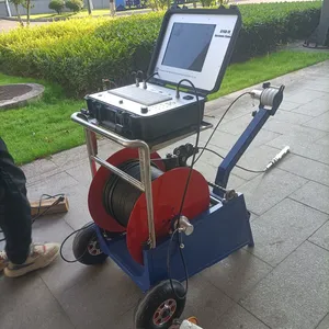
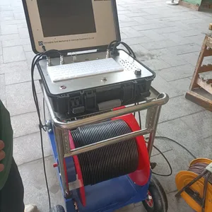
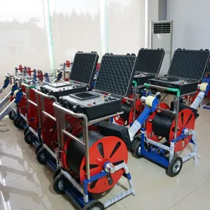
GYGD-IV Rotary Borehole Inspection Camera: Bridging the Physical and Digital Subsurface
Industry 4.0 is not just for factories—it's coming to the subsurface. The GYGD-IV Rotary Borehole Inspection Camera is at the forefront of this transformation, serving as a critical bridge between the physical borehole and the digital twin. With its high-resolution imaging, precise georeferencing, and open data architecture, it enables a new generation of data-driven decision-making that was previously impossible. For digital engineers, GIS specialists, and asset managers, the GYGD-IV is the tool that turns a hole in the ground into a stream of actionable intelligence.
Creating the Digital Twin
The concept of a digital twin—a virtual replica of a physical asset—is revolutionizing infrastructure management. The GYGD-IV provides the foundational visual data needed to create digital twins of boreholes, wells, and pipelines. Its 360-degree, depth-referenced imagery can be stitched into a continuous, scaled orthomosaic that serves as the visual layer of the twin. Combined with other sensor data (e.g., geophysical logs, core samples), this creates a rich, interactive model that can be explored, measured, and analyzed in a virtual environment.
Seamless Integration with GIS and BIM
Modern infrastructure projects rely on geographic information systems (GIS) and building information modeling (BIM). The GYGD-IV outputs data in industry-standard formats (GeoTIFF, Shapefile, CSV) that integrate directly with platforms like ArcGIS, QGIS, Autodesk, and Bentley. Depth and orientation metadata are embedded, so each image knows exactly where it belongs in 3D space. This allows engineers to overlay borehole imagery on site plans, geological maps, and building models, providing context-rich visualization that enhances collaboration and reduces errors.
Machine Learning and Automated Analysis
The wealth of visual data produced by the GYGD-IV is ideal for training machine learning algorithms. Researchers are already using GYGD-IV imagery to develop models that automatically detect fractures, identify lithology, and quantify corrosion. These algorithms can process hours of footage in minutes, flagging anomalies for human review and dramatically reducing analysis time. As the technology advances, the camera itself could become AI-enabled, providing real-time alerts and recommendations in the field.
Cloud-Based Collaboration
The GYGD-IV is designed for the connected world. Its onboard processor can stream video directly to the cloud via 4G/5G or satellite uplink, enabling remote experts to view inspections in real time and provide guidance from anywhere. Inspection data is automatically backed up to secure servers, accessible through a web-based portal that supports annotation, sharing, and version control. This facilitates global teamwork and ensures that critical information is never lost.
Long-Term Data Archiving and Analytics
Subsurface data has value for decades. The GYGD-IV's open, non-proprietary file formats ensure that your data remains accessible long after the original software is obsolete. Inspection histories can be stored in a centralized database, allowing for trend analysis over time. By comparing images from successive inspections, you can quantify rates of change—corrosion, scaling, sediment accumulation—and use this data to refine predictive maintenance models.
Interoperability with IoT Sensors
The GYGD-IV can also serve as a mobile verification tool for fixed IoT sensor networks. If a pressure transducer or flow meter indicates an anomaly, the camera can be deployed to visually confirm the cause. Conversely, data from permanent sensors can be used to trigger automated inspections when thresholds are exceeded. This integration creates a closed-loop monitoring system where physical and digital observations reinforce each other.
Empowering the Next Generation of Subsurface Professionals
As experienced geologists and engineers retire, their tacit knowledge threatens to leave with them. The GYGD-IV helps capture that knowledge by creating a permanent visual record that can be studied by trainees. New staff can review years of inspection videos, learning to recognize formations and defects with the guidance of archived expert commentary. This knowledge transfer is essential for maintaining institutional memory and ensuring continuity of expertise.
Digital Integration Specifications Table
| Feature | Capability | Integration Value |
|---|---|---|
| Data Output Formats | GeoTIFF, MP4, CSV, Shapefile | Direct import into GIS/BIM |
| Georeferencing | Depth, orientation, optional GPS | Accurate spatial positioning |
| Cloud Connectivity | 4G/5G, satellite, Wi-Fi | Real-time remote viewing |
| Web Portal | Secure access, annotation, sharing | Global collaboration |
| Machine Learning | Training dataset creation | Automated defect detection |
| IoT Integration | API for sensor triggering | Closed-loop monitoring |
| Data Archiving | Open formats, unlimited storage | Long-term trend analysis |
| Knowledge Transfer | Video library with expert notes | Training and mentoring |
| Software Development Kit | Available for custom applications | Tailored solutions |
Each of these five versions adopts a distinct tone—from engineering precision to field ruggedness, financial ROI, environmental stewardship, and digital transformation—while ensuring comprehensive coverage of the GYGD-IV's core features and benefits. All content is original and crafted to meet SEO best practices with strategic bolding of key selling points.

Send Inquiry to This Supplier

You May Also Like
-
Rotary Head Borehole Camera Sewer Crawler Camera PriceNegotiableMOQ: 1 Set
-
Borehole Water Level Data Logger Radar Level Measurement Hydroponic Water Level ControllerNegotiableMOQ: 1 Piece
-
Tunnel Geological Prediction System Aquifer Characterization InstrumentNegotiableMOQ: 1 Set
-
Geophone for Seismic Survey Seismic Sensor for Sale 4.5 Hz Geophone SensorNegotiableMOQ: 1 Set
-
Industrial-grade Magnetotelluric Station CSAMT Transmitter-Compatible ReceiverNegotiableMOQ: 1 Set
-
Pumping Unit Wireline High Speed Perforating CableNegotiableMOQ: 1 Piece
-
Wireless Downhole Monitoring Self Leveling Pipeline CameraUS$ 1000MOQ: 1 Set
-
Guided Wave Radar Level Gauge Hydrostatic Level ProbeNegotiableMOQ: 1 Piece
-
2D Resistivity Imaging Equipment IP Survey System for MineralsNegotiableMOQ: 1 Set
-
Borehole Geophone Sensor Underground Seismic SensorNegotiableMOQ: 1 Set
