

Geomagnetic Field Instrument High Speed Magnetometer Magnetic Field Sensor


Related Products
-
 Portable Logging Winch 3000m Logging Winch Borehole Downhole Logging WinchNegotiableMOQ: 1 Piece
 -
Sewer Crawler Camera Price High Temp Borehole CameraUS$ 5000MOQ: 1 Set
-
Deep Water Well Inspection Camera Underground Underwater Borehole Inspection CameraUS$ 1 - 1MOQ: 1 Piece
-
360 Degree Rotation Underwater Deep Water Well Inspection CameraUS$ 1 - 1MOQ: 1 Piece
-
Waterproof Underwater Manhole and Borehole Inspection CameraUS$ 1 - 1MOQ: 1 Piece
The Architectural Triumph of Design Thinking in Modern Geophysical Instrumentation
The evolution of scientific instrumentation is rarely marked by revolutionary leaps; more often, it progresses through a series of incremental refinements, each addressing a specific limitation of its predecessor. The WCZ-3 Proton Precession Magnetometer, however, represents something fundamentally different—a paradigmatic shift in how a geophysical instrument can be conceived, integrated, and experienced by the field practitioner. This transformation did not occur by accident; it is the direct result of a rigorous design thinking process that began not with technical specifications, but with a deep interrogation of user needs, field realities, and the unspoken frustrations that have long characterized magnetic surveying. The instrument that emerged from this process is not merely an assemblage of components meeting performance targets; it is a harmoniously integrated system where every design decision, from the placement of a connector to the architecture of the signal processing chain, reflects a deliberate intention to elevate the entire survey experience.
The Tyranny of External Components and the Liberation of Integration
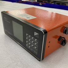
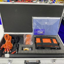
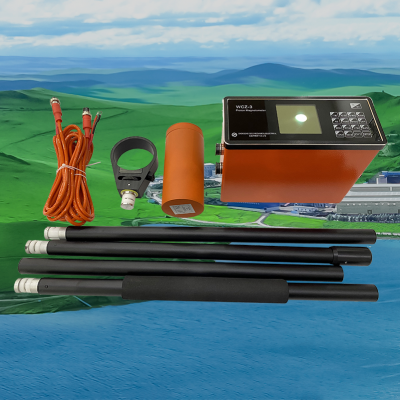
For decades, the field magnetometer has been characterized by a fragmented physical architecture: a sensor on a staff, a separate control box worn on a harness, an external GPS antenna mounted on a pole, and a tangle of cables connecting them all, each cable a potential point of failure, each connection a moment of lost time. The WCZ-3's design team began by asking a deceptively simple question: "What if everything the instrument needed to function could reside within a single enclosure?" The answer to that question is the instrument's revolutionary vertical form factor, a design that integrates the GPS antenna, the high-sensitivity GNSS receiver, the dual 32-bit processing core, the power management circuitry, and a high-capacity lithium-ion battery into a single, sealed, and balanced host unit. This integration is not merely an aesthetic choice; it is a fundamental rethinking of field reliability. By eliminating external components, the design removes the most common sources of field failure—damaged cables, corroded connectors, and loose connections—while simultaneously reducing setup time from minutes to seconds. The operator simply attaches the sensor probe, powers on the instrument, and begins surveying. This liberation from component management allows the field scientist to focus entirely on the geophysical task at hand, transforming the relationship between operator and instrument from one of constant maintenance to one of seamless partnership.
The Gradient Problem: Engineering Beyond the Specification Sheet
Perhaps no single challenge has historically limited the utility of proton magnetometers more than their sensitivity to magnetic field gradients. In the presence of steep gradients—precisely the conditions encountered near mineralized zones, geological contacts, or buried cultural features—traditional instruments would produce erratic readings or fail entirely, leaving the surveyor with blind spots over the very areas of greatest interest. The WCZ-3's development team approached this problem not as an inevitable limitation of the technology, but as an engineering challenge to be systematically overcome. The result is a multi-layered approach to gradient resilience that begins with optimized sensor geometry to minimize signal distortion, continues through advanced analog front-end design that preserves signal fidelity under challenging conditions, and culminates in proprietary digital signal processing algorithms capable of extracting valid measurements from signals that would be rejected by conventional systems. This comprehensive approach yields an operational gradient tolerance of 8,000 nanoteslas per meter, a specification that fundamentally expands the instrument's usable envelope.
Yet the design team recognized that even this enhanced tolerance might be insufficient in the most extreme environments. Their response was the development of a unique "Estimation Mode" algorithm, a sophisticated digital signal processing technique that analyzes partially degraded free induction decay signals to derive a scientifically reasoned estimate of the local field strength when standard measurement is impossible. This feature ensures that no survey area becomes a complete data void, providing qualitative guidance for anomaly mapping and informing decisions about follow-up investigations. The gradient problem, long accepted as an unavoidable constraint of proton magnetometry, has been systematically deconstructed and addressed through thoughtful engineering at every level of the instrument's design.
Data Quality as a First-Principles Design Objective
In traditional instrument design, data quality is often treated as an outcome—something to be verified after the survey, during office-based processing and interpretation. The WCZ-3's design philosophy inverts this assumption, treating data quality as a first-principles objective that must be addressed at the point of acquisition. This thinking is embodied in the instrument's comprehensive real-time quality assessment system, which continuously monitors three critical parameters of the captured free induction decay signal: its initial amplitude (indicating signal strength), its exponential decay time constant (reflecting environmental conditions and sensor tuning), and its signal-to-noise ratio (quantifying the impact of ambient electromagnetic interference). These parameters are synthesized into an objective, multi-factor quality indicator displayed to the operator immediately after each measurement. This real-time feedback transforms the acquisition process from a blind recording exercise into an active quality assurance protocol, empowering the field scientist to make immediate decisions about measurement validity and the potential need for reacquisition.
The design thinking behind this feature recognizes that the most expensive data to correct is data that should never have been collected in the first place. By providing instantaneous, objective quality metrics at the point of measurement, the WCZ-3 enables operators to identify and address issues—whether related to sensor placement, environmental noise, or instrument settings—while still at the survey station, rather than discovering problems weeks later during office-based processing. This proactive approach to quality assurance not only improves the integrity of final datasets but also significantly reduces the time and cost associated with data cleaning and reacquisition.
The Integration of Time and Space: Beyond Simple Positioning
The inclusion of GPS receivers in geophysical instruments is now commonplace, but the WCZ-3's design team recognized that positioning is merely the foundation upon which a more sophisticated capability should be built. Their thinking extended to the question of how spatial and temporal data could be deeply integrated into every aspect of instrument operation and data management. The result is a system where the GNSS receiver does far more than simply log coordinates. It provides the basis for intelligent survey navigation, allowing pre-programmed grids to be imported and guiding operators along transects with real-time graphical feedback. It enables support for multiple coordinate systems and map projections, including global systems like latitude/longitude and UTM as well as local grids such as Beijing 54 and Xi'an 80, ensuring seamless integration with existing project data. Most critically, it provides the timing signal that disciplines the instrument's internal real-time clock, synchronizing every measurement to Coordinated Universal Time with millisecond accuracy.
This temporal precision is not a minor refinement; it is essential infrastructure for any survey requiring diurnal variation correction. Traditional correction methods assume perfect temporal alignment between mobile and base station measurements, an assumption that is rarely valid with uncorrected internal clocks. The WCZ-3's GPS-disciplined timing eliminates this uncertainty, ensuring that the timestamps on mobile and base station readings are truly comparable. This enables more accurate diurnal corrections, which in turn allows the extraction of weaker anomaly signals from the corrected data. The integration of time and space thus becomes not just a convenience but a fundamental enhancement of the instrument's core measurement capability.
The User Interface as Cognitive Prosthetic
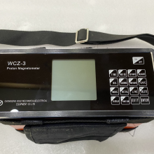
Perhaps nowhere is the WCZ-3's design thinking more evident than in its user interface, which functions as a true cognitive prosthetic for the field scientist. The design team recognized that the instrument would be used under demanding conditions—bright sunlight, pouring rain, the fading light of dusk—by operators whose primary attention must be on the survey task, not on navigating complex menus. The interface they developed is a model of cognitive ergonomics, organizing functions into a logical, depth-efficient menu structure that minimizes keystrokes and reduces the potential for error. The 160 by 160 pixel backlit graphical display presents information with exceptional clarity, and its ability to render real-time plots of magnetic field strength provides immediate visual insight into anomaly characteristics that would be invisible in numeric form alone.
The interface design extends to the physical controls as well. The 16-key membrane keypad provides positive tactile feedback that remains reliable even when operated with gloved hands, a critical consideration for surveys in cold climates or challenging terrain. The key layout follows conventional telephone arrangement, leveraging existing user familiarity to reduce training requirements. Every design decision, from the spacing of the keys to the contrast of the display, reflects a deep understanding of the physical and cognitive demands of field geophysics. The result is an instrument that feels intuitive from the first use, allowing operators to achieve proficiency within a single field day and to maintain focus on geological interpretation rather than instrument operation.
| Comprehensive Design Specifications | Detailed Parameters |
|---|---|
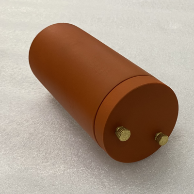
| Integrated Physical Architecture | Single-unit vertical host (206 mm x 85 mm x 155 mm) containing GPS antenna, GNSS receiver, dual 32-bit processors, power management, and lithium-ion battery; Total host weight: 1.5 kg. |
| Gradient Engineering | Maximum operational gradient: 8,000 nT/m; Proprietary high-gradient algorithms; "Estimation Mode" for extreme conditions. |
| Real-Time Quality Assessment | Multi-parameter analysis of signal amplitude, decay constant (T2*), and signal-to-noise ratio; Objective on-screen quality indicator. |
| Spatiotemporal Integration | Multi-constellation GNSS (GPS/GLONASS/BEIDOU); Positional accuracy |
| Cognitive Interface Design | 160 x 160 pixel backlit graphic LCD; 16-key tactile keypad; Depth-efficient menu structure; Real-time graphical field strength display. |
| Complete System Specifications | Measurement range: 20,000 - 100,000 nT; Standard accuracy: ±1 nT (0.1 nT resolution); Fine mode accuracy: ±0.5 nT (0.05 nT resolution); Storage capacity: >2,000,000 readings; Operating temperature: -10°C to +50°C. |

Send Inquiry to This Supplier


You May Also Like
-
Borehole Water Well Inspection CCTV Camera Well LoggerNegotiableMOQ: 1 Piece
-
Resistivity Calibration Instrument Geophysical Resistivity Sensor Array Resistivity Data LoggerNegotiableMOQ: 1 Set
-
Mineral Exploration Data Interpretation Geophysical Prospecting Consulting Service Underground Cavity Detection SystemNegotiableMOQ: 1 Set
-
Multi Functional Pipe Inspection Camera Wireless Drain Inspection Camera Monitor High Pressure Waterproof Borehole CameraUS$ 5000MOQ: 1 Set
-
Resistivity Cable Testing System Time Domain IP Measurement SystemNegotiableMOQ: 1 Set
-
Passive Source Seismic Sensor Borehole Seismic Sensor Node Seismic Sensor for Dam MonitoringUS$ 500MOQ: 1 Set
-
ARM FPGA Data Acquisition System Remote Reference MT Station IP Resistivity Imaging EquipmentNegotiableMOQ: 1 Set
-
4-20mA Water Level Transmitter Sewage Level Sensor Liquid Level SwitchNegotiableMOQ: 1 Piece
-
SP Measurement System VES Resistivity Survey KitNegotiableMOQ: 1 Set
-
Seismic Impact System Geotechnical Seismic Source Surface Wave Seismic SourceUS$ 500MOQ: 1 Set
