

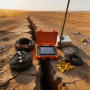
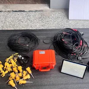
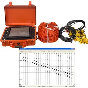
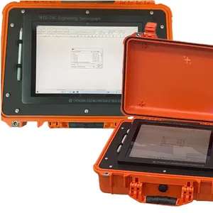
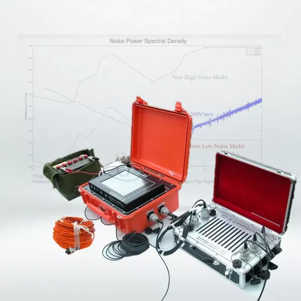
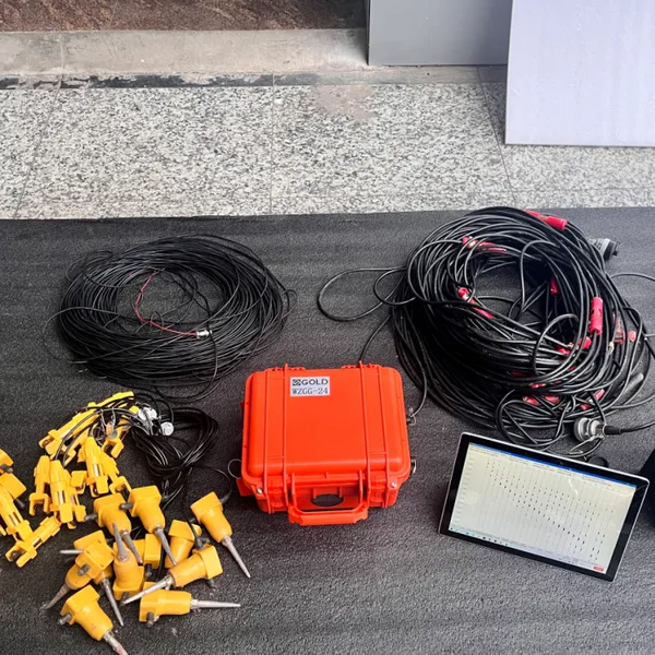
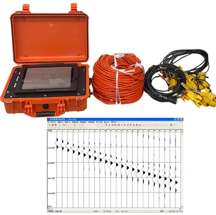
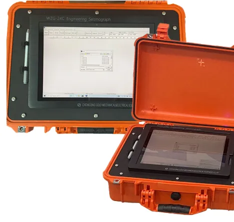
Multi Channel Engineering Seismograph Remi Engineering Seismograph


Related Products
-
 Geological Drillhole Inspector Mining Drillhole Imager EquipmentNegotiableMOQ: 1 Piece
 -
Deep Water Well Inspection Camera Underground Underwater Borehole Inspection CameraUS$ 1 - 1MOQ: 1 Piece
-
360 Degree Rotation Underwater Deep Water Well Inspection CameraUS$ 1 - 1MOQ: 1 Piece
-
Waterproof Underwater Manhole and Borehole Inspection CameraUS$ 1 - 1MOQ: 1 Piece
-
Borehole Water Well Inspection CCTV Camera Well LoggerNegotiableMOQ: 1 Piece
WZG 24C/48C Seismograph: Making Dangerous Legacy Sites Safe for New Uses
Confronting the Subsurface Legacy of Industrial Extraction
Hundreds of thousands of abandoned mines honeycomb the ground beneath communities worldwide. These legacies pose risks: sudden subsidence, acid mine drainage, mine gas migration, and unstable slopes. Redeveloping these brownfields into solar farms, housing, or parks requires comprehensive subsurface hazard mapping, yet traditional borehole investigations often miss hidden voids or deteriorating pillars. The WZG 24C/48C is engineered as an abandoned mine land characterization system, providing high resolution 3D imaging of subsurface mine workings. For reclamation engineers, developers, and state abandoned mine land (AML) programs, it transforms a dangerous unknown into a manageable redevelopment asset.
Detecting Undocumented Mine Workings and Collapse Zones
Many abandoned mines have incomplete or inaccurate maps. Workings often extend far beyond recorded boundaries. The WZG 24C/48C deploys surface based passive and active seismic arrays to image the subsurface for the characteristic signatures of mine workings: low velocity zones (voids), collapsed zones (rubblized material), and standing pillars. Its full waveform inversion algorithms resolve individual mine entries, rooms, and pillars at depths up to 100 meters. The resulting 3D mine map is often far more detailed than the original mine plans, revealing unknown voids directly beneath proposed building footprints. This intelligence is the foundation for safe redevelopment.
Assessing Pillar Deterioration and Roof Integrity
Even where mine maps are accurate, the condition of the works may have degraded over decades of water infiltration, freeze thaw action, and rock creep. The WZG 24C/48C can estimate pillar load and stability through analysis of seismic wave attenuation and velocity anisotropy. Pillars under high stress exhibit different seismic properties than stable ones. Similarly, it can detect delamination of the mine roof or the development of stress fractures in the overlying rock. This condition assessment allows engineers to prioritize intervention: which pillars need reinforcement? Which roof zones require monitoring? Which areas can safely support new construction without treatment?
Technical Specifications for Abandoned Mine Reclamation
| Mine Reclamation Feature | Redevelopment Safety and Cost Impact |
|---|---|
| 3D Void and Pillar Detection via Seismic Tomography | Maps mine workings at depths of 5 to 100 meters with sub meter resolution. |
| Pillar Stability Index from Attenuation Tomography | Estimates load condition of standing pillars to identify failure risks. |
| Delamination and Roof Fracture Imaging | Identifies zones of weak ground above mine voids for targeted grouting. |
| Collapse Zone Delineation (Rubblized vs. Intact) | Distinguishes areas of historic subsidence from stable ground. |
| Mine Gas Pathway Mapping via Passive Acoustics | Detects gas migration pathways through fractured overburden. |
| Integration with Subsidence Hazard Models | Feeds ground truth data into predictive models of future sinkhole formation. |
| Public AML Program Reporting Module | Formats data for state and federal abandoned mine land inventory requirements. |
Targeting Remediation and Reducing Reclamation Costs
Treating an entire abandoned mine site to a uniform safety standard is prohibitively expensive. The WZG 24C/48C enables risk based, targeted remediation. Instead of grouting all possible voids, the mine map shows exactly which voids lie under future construction. Instead of shoring all pillars, the pillar stability analysis highlights only those at risk. This precision remediation reduces reclamation costs by 60% to 80%, making previously uneconomic sites viable for redevelopment. The system pays for itself by identifying low risk zones that can be safely left untreated.
Unlocking Land Value and Community Reinvestment
Abandoned mine lands are often blighted, depressing property values and community tax bases. By providing a certified subsurface safety case, the WZG 24C/48C unlocks this latent land value. A site previously considered unbuildable can attract a solar developer. A park feared for sinkholes can be safely opened. A neighborhood long blighted by mine hazard designation can be reclassified, freeing homeowners from insurance and finance restrictions. In this way, the system is not merely an engineering tool; it is an engine for economic and social renewal, transforming a hazardous industrial legacy into the foundation for a safer, more prosperous community.

Send Inquiry to This Supplier


You May Also Like
-
Resistivity Calibration Instrument Geophysical Resistivity Sensor Array Resistivity Data LoggerNegotiableMOQ: 1 Set
-
Seismic Investigation for Dam Safety Seismic Anisotropy Measurement System Offshore Seismic Data Acquisition KitUS$ 3000MOQ: 1 Set
-
Mineral Exploration Data Interpretation Geophysical Prospecting Consulting Service Underground Cavity Detection SystemNegotiableMOQ: 1 Set
-
Multi Functional Pipe Inspection Camera Wireless Drain Inspection Camera Monitor High Pressure Waterproof Borehole CameraNegotiableMOQ: 1 Set
-
Resistivity Cable Testing System Time Domain IP Measurement SystemNegotiableMOQ: 1 Set
-
Passive Source Seismic Sensor Borehole Seismic Sensor Node Seismic Sensor for Dam MonitoringUS$ 500MOQ: 1 Set
-
ARM FPGA Data Acquisition System Remote Reference MT Station IP Resistivity Imaging EquipmentNegotiableMOQ: 1 Set
-
4-20mA Water Level Transmitter Sewage Level Sensor Liquid Level SwitchNegotiableMOQ: 1 Piece
-
SP Measurement System VES Resistivity Survey KitNegotiableMOQ: 1 Set
-
Seismic Impact System Geotechnical Seismic Source Surface Wave Seismic SourceUS$ 500MOQ: 1 Set
