

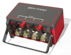
Environmental EM Survey Magnetotellurometer Geotechnical Investigation Sounding Equipment


Related Products
-
 Deep Water Well Inspection Camera Underground Underwater Borehole Inspection CameraUS$ 1 - 1MOQ: 1 Piece
 -
360 Degree Rotation Underwater Deep Water Well Inspection CameraUS$ 1 - 1MOQ: 1 Piece
-
Waterproof Underwater Manhole and Borehole Inspection CameraUS$ 1 - 1MOQ: 1 Piece
-
Borehole Water Well Inspection CCTV Camera Well LoggerNegotiableMOQ: 1 Piece
-
Resistivity Calibration Instrument Geophysical Resistivity Sensor Array Resistivity Data LoggerNegotiableMOQ: 1 Set
GD-5 Magnetotelluric System: Rapid Subsurface Assessment for Crisis Situations
Natural disasters and industrial accidents often require immediate subsurface information to guide emergency response. Floods can destabilize levees, earthquakes can rupture buried pipelines, and chemical spills can contaminate groundwater. In these crisis situations, there is no time for lengthy survey planning or equipment familiarization. The GD-5 Magnetotelluric System is designed as a rapid-response asset that can be deployed within hours to provide critical subsurface intelligence. For emergency management agencies, environmental response teams, and infrastructure operators, the GD-5 offers the speed, simplicity, and reliability needed when minutes matter.
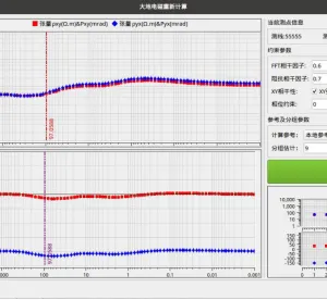
The emergency response capability begins with the system’s instant-on readiness. The GD-5 requires no warm-up period, no baseline calibration, and no complex setup. From power-on to first data, the time is measured in minutes. The system’s intuitive interface allows operators with basic training to begin collecting usable data immediately, without consulting thick manuals or recalling complex procedures. For situations where the responding team may not be the regular user of the equipment, the GD-5’s self-explanatory operation minimizes the learning curve. Color-coded status indicators, automated self-tests, and guided workflows ensure that even infrequent users can deploy the system correctly under stress.
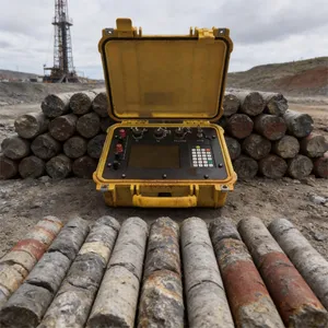
The GD-5’s physical characteristics suit emergency deployment. The entire system fits into a small case that can be carried on commercial aircraft, stored in an emergency response vehicle, or transported by helicopter to inaccessible sites. The system operates on battery power, requiring no generator fuel that might be unavailable in a disaster zone. IP sixty-seven sealing allows deployment in rain, snow, or flood conditions without protective shelter. The wide operating temperature range means the system works in the environment as found, whether that is a frozen levee or a fire-damaged industrial site. For emergency managers who must preposition equipment for potential incidents, the GD-5’s compact storage and minimal maintenance requirements make it practical to keep on hand.
| Emergency Scenario | GD-5 Rapid Response Feature | Critical Intelligence Provided |
|---|---|---|
| Levee Integrity Check | Rapid deployment; real-time shallow profiling (HMT mode). | Identifies internal erosion zones or developing seepage paths before catastrophic failure. |
| Pipeline Rupture | Non-invasive survey; battery operation; all-weather capability. | Maps subsurface product migration; guides excavation priorities for spill containment. |
| Earthquake Aftermath | Portable, one-person deployable; robust construction. | Assesses ground stability; locates buried utilities and fractured zones for repair crews. |
| Landslide Threat | Continuous monitoring mode; remote data access. | Tracks moisture changes in unstable slopes; supports evacuation decisions. |
| Dam Safety Inspection | Low-frequency deep penetration; ability to work on concrete surfaces. | Detects foundation seepage or internal erosion within embankment dams. |
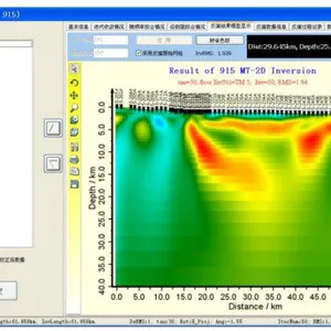
Beyond immediate crisis response, the GD-5 supports post-disaster recovery and reconstruction. After a flood, the system can map changes in riverbed depth and sediment distribution to guide channel restoration. After an earthquake, it can characterize ground conditions for rebuilding decisions—identifying areas of liquefaction potential or stable bedrock. For environmental incidents, the GD-5 provides the baseline data needed for effective remediation design. The system’s ability to produce defensible, documented data is also valuable for insurance claims, legal proceedings, and regulatory reporting following an incident. In the aftermath of a disaster, the GD-5 helps communities rebuild on a foundation of accurate subsurface information. It is an emergency response tool, a recovery planning tool, and a long-term risk management asset—all in one rugged, reliable package.

Send Inquiry to This Supplier


You May Also Like
-
Mineral Exploration Data Interpretation Geophysical Prospecting Consulting Service Underground Cavity Detection SystemNegotiableMOQ: 1 Set
-
Multi Functional Pipe Inspection Camera Wireless Drain Inspection Camera Monitor High Pressure Waterproof Borehole CameraNegotiableMOQ: 1 Set
-
Resistivity Cable Testing System Time Domain IP Measurement SystemNegotiableMOQ: 1 Set
-
Passive Source Seismic Sensor Borehole Seismic Sensor Node Seismic Sensor for Dam MonitoringUS$ 500MOQ: 1 Set
-
ARM FPGA Data Acquisition System Remote Reference MT Station IP Resistivity Imaging EquipmentNegotiableMOQ: 1 Set
-
4-20mA Water Level Transmitter Sewage Level Sensor Liquid Level SwitchNegotiableMOQ: 1 Piece
-
SP Measurement System VES Resistivity Survey KitNegotiableMOQ: 1 Set
-
Seismic Impact System Geotechnical Seismic Source Surface Wave Seismic SourceUS$ 500MOQ: 1 Set
-
Geomagnetic Field Instrument High Speed Magnetometer Magnetic Field SensorNegotiableMOQ: 1 Set
-
Portable Logging Winch 3000m Logging Winch Borehole Downhole Logging WinchNegotiableMOQ: 1 Piece
