

Fast Measurement Magnetometer GPS Magnetometer


Related Products
-
 Battery Powered Downhole Probe Wireless Geological Direction FinderNegotiableMOQ: 1 Set
 -
Screen Condition Downhole Tool Gravel Pack Visual Check CamNegotiableMOQ: 1 Set
-
Differential Pressure Level Transmitter Smart Level Sensor Iot EnabledNegotiableMOQ: 1 Piece
-
Streaming Potential Resistivity Meter Self-Potential Resistivity DeviceNegotiableMOQ: 1 Set
-
Seismic Refraction Equipment Seismic Cable With ConnectorsNegotiableMOQ: 1 Set
The Field Instructor‘s Curriculum – Teaching Magnetic Surveying with the WCZ-3
Every experienced geophysicist remembers the first instrument they learned on: the confusing array of cables, the cryptic error codes, the sinking feeling when a day’s data proved unusable back in the office. The WCZ-3 has been designed to transform that learning experience, serving as an ideal instructional platform for universities, training programs, and field mentoring. This version examines the instrument through the eyes of the instructor who must equip the next generation of geoscientists with both theoretical understanding and practical competence.
The First Hour: From Unboxing to First Data
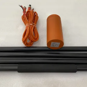
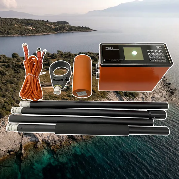
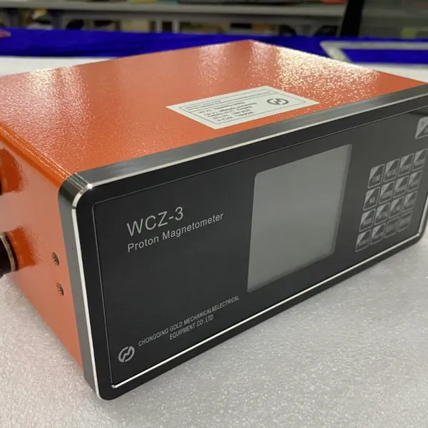
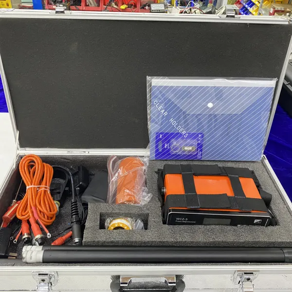
The training session begins with the student opening the carrying case. Unlike traditional systems with separate GPS antennas, battery packs, and control boxes, the WCZ-3 presents a single host unit and a single sensor probe. The instructor asks: “What needs to be connected?” The answer: just the probe cable to the host. No external antenna, no power cable, no tangled harness. Within sixty seconds, the student has assembled the system. The backlit display powers on, and the instrument automatically searches for GPS satellites. While waiting for a fix (typically under one minute), the instructor points out the battery status indicator and the menu structure—only four top-level menus, each with logically grouped functions. The student navigates to the measurement screen without prompting. The first reading appears: a stable field value with a green quality indicator. The student has successfully acquired data with no prior training beyond unboxing.
Understanding the Measurement Cycle
The WCZ-3’s two-second measurement cycle allows a training exercise to progress rapidly. Students can experiment with sensor orientation, probe height, and environmental variables, observing the real-time quality score change with each adjustment. The instructor explains the three underlying metrics: signal amplitude (affected by polarizing field efficiency), decay constant (sensitive to magnetic homogeneity), and signal-to-noise ratio (influenced by nearby metal or power lines). The student learns to interpret the quality score not as an abstract number but as a diagnostic tool. When the score drops, they investigate: is the probe too close to a steel belt buckle? Is the staff wobbling during the measurement? Is a vehicle idling nearby? The WCZ-3 transforms abstract principles of magnetic surveying into immediate, tangible feedback.
Teaching Gradient Tolerance
A common point of confusion for students is why magnetometers fail in steep gradients. The WCZ-3’s 8,000 nT/m specification provides a generous envelope, but the instructor deliberately creates high-gradient scenarios: placing the probe near a steel fence post, then progressively moving away. The student watches the quality score decline, then recovers. At the extreme, when the instrument switches to Estimation Mode, the instructor explains the algorithm’s purpose: not a replacement for standard measurement, but a qualitative guide to anomaly boundaries. This hands-on demonstration fixes the concept of gradient effects more effectively than any textbook diagram.
Navigating a Survey Grid
The instructor pre-loads a small survey grid (e.g., 10 by 10 stations at 2-meter spacing) onto the WCZ-3 using a simple text file. The student selects “Navigation” mode and sees the display change to a graphical interface: an arrow pointing toward the next station, a distance counter decreasing, and a small map of the grid with completed stations marked. The student walks the grid without tape, compass, or flagging. The real-time deviation display keeps them on line. After completing the grid, the instructor connects the WCZ-3 to a laptop, and the student copies the data file. The CSV format opens immediately in spreadsheet software. The instructor demonstrates diurnal correction using the base station file (collected automatically by a second WCZ-3 left running on a tripod). Within minutes, the student has produced a contour map of the simulated anomaly. In a single afternoon, the student has experienced the entire workflow: setup, navigation, acquisition, quality assessment, data transfer, and basic processing.
Teaching Quality Assurance
The WCZ-3’s per-station quality score provides an objective basis for teaching data acceptance criteria. The instructor asks: “What quality score is acceptable?” The answer depends on the survey objective. For regional reconnaissance, a score of 6 might suffice; for a detailed gradient survey supporting a drill target, only 8 or above is acceptable. The student learns to document rejected stations and the reasons for rejection. The instrument’s event log records any system anomalies (low battery, GPS dropout, temperature extremes), teaching the importance of metadata for data defensibility. By the end of the training module, the student can articulate the difference between a measurement that is numerically precise and one that is geophysically reliable.
Common Student Mistakes and How the WCZ-3 Mitigates Them
Forgetting to level the probe: The WCZ-3’s proton precession principle is insensitive to probe orientation within broad limits, so this common fluxgate error simply doesn’t occur.
Misidentifying cultural interference: The real-time quality score drops immediately when the probe nears ferrous objects, teaching students to recognize and avoid them.
Losing position in the grid: The GPS navigation display eliminates this entirely; students cannot wander off-line without seeing the deviation indicator.
Skipping base station measurements: The instructor demonstrates the difference between corrected and uncorrected data using the base station file, reinforcing the necessity.
Failing to document measurement conditions: The WCZ-3’s automatic metadata capture (time, coordinates, temperature, quality score) provides the documentation automatically.
| Training-Focused Specification | Benefit for Instruction |
|---|---|
| Setup Time (unpack to first reading) | |
| Measurement Cycle | 2 seconds → rapid iteration, immediate feedback |
| Quality Score (0-10) | Objective, teachable acceptance criteria |
| Estimation Mode | Demonstrates gradient effects practically |
| GPS Navigation Display | Eliminates tape/compass errors in student grids |
| CSV Data Format | Opens in any spreadsheet → no software cost |
| Automatic Metadata | Teaches documentation importance |
| Backlit Display | Works in classroom or field, any lighting |
| Rugged Design | Withstands student handling errors |
| Training Required |

Send Inquiry to This Supplier


You May Also Like
-
TEM Data Stacking Software Shallow Subsurface Imaging SystemNegotiableMOQ: 1 Set
-
Slope Angle Monitoring Sensor Inclinometer For EmbankmentNegotiableMOQ: 1 Set
-
Interface Level Measurement Oil Water Sludge Blanket Level DetectorNegotiableMOQ: 1 Piece
-
Aquifer Geometry Tool Saturation Monitoring UnitNegotiableMOQ: 1 Set
-
Borehole Geophone For VSP Survey High Temperature Borehole GeophoneNegotiableMOQ: 1 Set
-
Transformer Coupled Hydrophone Voltage Sensitivity HydrophoneNegotiableMOQ: 1 Set
-
Environmental EM Survey Magnetotellurometer Geotechnical Investigation Sounding EquipmentNegotiableMOQ: 1 Set
-
Double Drum Logging Winch Well Logging WinchNegotiableMOQ: 1 Piece
-
High Speed Downhole Camera Centralizer Borehole CameraNegotiableMOQ: 1 Set
-
High Accuracy Water Level Measuring Device Stainless Steel Water Level SensorNegotiableMOQ: 1 Piece
