

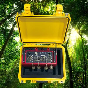
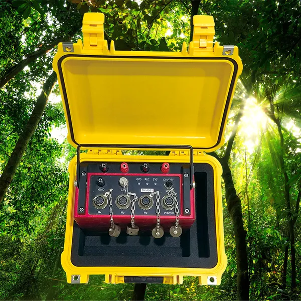
Controlled Source MT System Portable MT Survey Kit


Related Products
-
 Pour Point Lowering Wire 8kN Logging CableNegotiableMOQ: 1 Piece
 -
Dam Foundation Inspection Cam Tunnel Grouting Check CameraNegotiableMOQ: 1 Set
-
Well Depth Sounding Device Remote Water Level TelemetryNegotiableMOQ: 1 Piece
-
High-Resolution IP Chargeability Meter Cross-Hole Resistivity Tomography SystemNegotiableMOQ: 1 Set
-
Professional Seismic Source Compact Seismic SourceUS$ 500MOQ: 1 Set
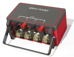
GD-5 Magnetotelluric System: Building the Connected Subsurface Model
Modern geoscience projects increasingly require integration of multiple data types—magnetotelluric, seismic, gravity, magnetic, and drilling information—into coherent subsurface models. The GD-5 Magnetotelluric System is designed as a data integration platform, producing outputs that seamlessly combine with other geophysical and geological datasets. It achieves this through standardized formats, comprehensive metadata, and open architecture that facilitates interoperability. For teams building multi-disciplinary earth models, the GD-5 provides magnetotelluric data that fits naturally alongside other information sources.
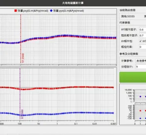
The integration capability begins with the system's output philosophy. All GD-5 data is recorded in the industry-standard SEG-EDI format, which is widely supported by inversion, modeling, and GIS software. This format preserves not only the measured impedance and phase data but also the spatial coordinates, temporal information, and survey geometry needed to position results correctly in a project-wide framework. Unlike proprietary formats that require custom converters, SEG-EDI files can be opened directly in most geophysical and geological software packages, eliminating data translation delays and errors.
Complementing the standard data format is the GD-5's rich metadata capture. Each survey file records instrument settings, sensor calibrations, timing status, noise conditions, and operator notes. This information is essential when combining magnetotelluric data with other datasets, as it provides context for assessing data quality and resolving apparent discrepancies. For example, a weak MT response that might suggest low-resistivity material could be cross-referenced with metadata indicating high cultural noise levels, leading to a different interpretation than if the data were considered in isolation. The GD-5's documentation completeness supports intelligent integration, not just mechanical merging.
| Integration Attribute | GD-5 Technical Provision | Multi-Disciplinary Benefit |
|---|---|---|
| Standard Data Format | SEG-EDI output with full impedance tensor and error estimates. | Direct import into all major inversion, modeling, and GIS platforms without conversion. |
| Spatial Referencing | Precise GNSS coordinates for each station; integration-ready location headers. | Accurate registration with seismic profiles, drilling data, and geological maps. |
| Temporal Consistency | UTC time-stamped data; synchronization across all channels. | Allows time-lapse integration with monitoring data from other instruments. |
| Metadata Completeness | Calibration records, gain settings, noise metrics, and operator notes in every file. | Provides context for reconciling MT results with other datasets; supports quality-aware integration. |
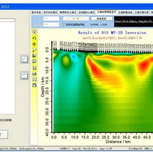
| Cross-Validation Support | Full tensor data allows joint inversion with seismic, gravity, and magnetic data. | Enables construction of more constrained, more reliable earth models through multi-physics inversion. |
The GD-5's data integration extends beyond output formats to workflow integration. The system's MTPRO preprocessing software produces outputs that feed directly into MT-Pioneer, industry-standard inversion codes, and custom processing pipelines. Real-time data can be streamed to cloud platforms for immediate availability to distributed team members. The system's compatibility extends to sensors and transmitters from multiple manufacturers, ensuring that existing equipment investments remain usable. For organizations with established workflows and software ecosystems, the GD-5 fits in without forcing change, respecting existing investments while bringing modern MT capability. It is the integrator's choice—a system that works with what you have and what you plan to acquire, building connected subsurface understanding from diverse data sources.

Send Inquiry to This Supplier

You May Also Like
-
Fast Measurement Magnetometer GPS MagnetometerNegotiableMOQ: 1 Set
-
Battery Powered Downhole Probe Wireless Geological Direction FinderNegotiableMOQ: 1 Set
-
Screen Condition Downhole Tool Gravel Pack Visual Check CamNegotiableMOQ: 1 Set
-
Differential Pressure Level Transmitter Smart Level Sensor Iot EnabledNegotiableMOQ: 1 Piece
-
Streaming Potential Resistivity Meter Self-Potential Resistivity DeviceNegotiableMOQ: 1 Set
-
Seismic Refraction Equipment Seismic Cable With ConnectorsNegotiableMOQ: 1 Set
-
TEM Data Stacking Software Shallow Subsurface Imaging SystemNegotiableMOQ: 1 Set
-
Slope Angle Monitoring Sensor Inclinometer For EmbankmentNegotiableMOQ: 1 Set
-
Interface Level Measurement Oil Water Sludge Blanket Level DetectorNegotiableMOQ: 1 Piece
-
Aquifer Geometry Tool Saturation Monitoring UnitNegotiableMOQ: 1 Set
