

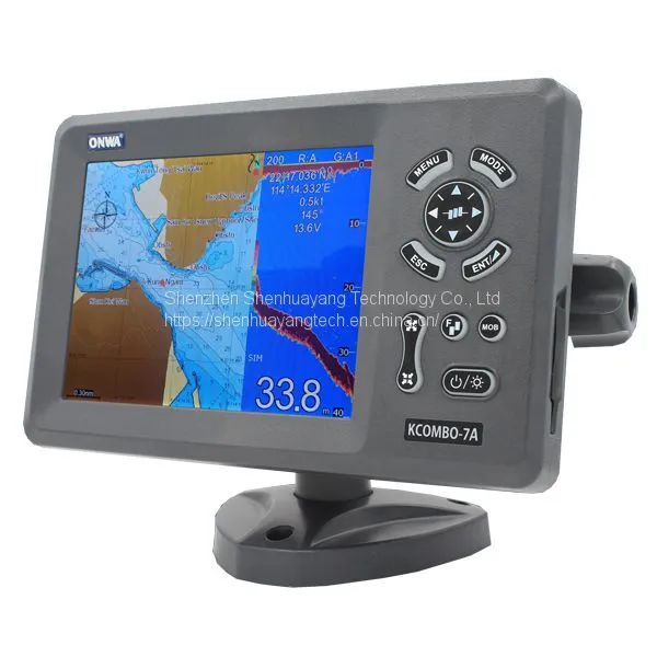
KCOMBO-7A Marine GPS Plotter and Find Fishing Combo With Internal GPS Antenna and Built-in Class B AIS Transponder

Related Products
-
 X3 Visual Fish Finder/ Underwater Camera With 4.3" Color LCD Display, 200M Pix, IP7 Waterproof, 30m CableUS$ 65 - 75MOQ: 2 Sets
 -
Fishing Tackle Fish FinderNegotiableMOQ: 1 Piece
-
10.4 Inch LCD Display Echo SounderNegotiableMOQ: 1 Piece
-
Echo Sounder Fish FinderNegotiableMOQ: 1 Piece
-
5.6 Inch Color Lcd FishfindersNegotiableMOQ: 1 Kilogram
KCOMBO-7A
7″ Color LCD GPS C-Map MAX compatible plotter with Fishfinder Combo with Internal GPS Antenna and built-in Class B AIS Transponder
Features:
1. 7 inches High resolution LCD,640×480 pixels
2. Choice of External or Internal GPS Antenna (Specify when ordering)
3. Built-in Class B AIS Transponder
4. Easy to use menu operation
5. sunlight viewable
6. C-Map NT Max Compatible
7. Digital Fishfinder Technology
8. 50/200 KHz transom mount transducer(Optional Accessory)
9. Speed, Depth, water temperature and position
10. Ingress Protected to IP67
Specifications:
PLOTTER CHARACTERISTICS | |
1. Waypoints/icons |
12,000 user waypoints with name, symbol, |
2. Routes |
30 routes waypoint up to 170 points each, plus MOB and Track Navigation or Goto Track modes |
3. Tracks |
8,000 point automatic track log; 10 saved track (up to 8000 track points each)let you retrace your path in both directions |
4. Alarms |
XTE, Anchor drag, arrival, speed, voltage, proximity waypoint and time,AIS alarm. |
5. Pallete |
1. Normal 2. Daylight exposed to sunlight 3. Night in dark environment 4. NOAA paperchart colors |
6. Tides |
Tide data |
7. Projection |
Mercator projection |
8. Position format |
Lat/Lon |
9. Basemap |
Built-in Onwa K-Chart |
10. External Map |
SD Cards slot for C-Map MAX |
11. User data storage |
Internal backup of user settings, or external SD-card |
12. Plot Interval |
1s to 99h or 0.01 nm to 9.99nm |
13. Plotting scales |
0.01nm to 1,000nm |
14. Nav Datat |
Inputs:$–DBT, $–DPT, $–GGA, $–GLL,$–GSA, $–GSV, $–HDG,$–HDM,$–HDT,$–MTW, $–RMB,$–RMC, $–VTG, $–ZDA, $–VWR,$–VWT,$–MWD, $–VPW Outputs: $–AAM, $–APB, $–BOD,$–BWC,$–GGA, $–GLL, $–RMB,$–RMC,$–VTG, $–XTE, $–ZDA, $–DBT $–DPT, $–WPL, $–ZDL, $–ZTG Outputs for autopilot: $–AAM, $–APB, $–BOD,$–VTG, $–DBT, $–DPT |
15. Perspective View |
On/off |
16. Celestial |
Sunrise/Sunset Moonrise/Moonset |
POWER SUPPLY |
10.5 to 35VDC, current drain 1.0A at 12V |
PHYSICAL | |
1. Size |
243mm(H) X 155mm(W) X 82mm(D) |
2. Weight |
0.6kg |
3. Display |
7 inches Color TFT dayview LCD,800×600 pixels |
4. Waterproofing |
Display unit: IPX6 |
5. Temperature range |
Display unit: -15℃ to +55℃ Antenna unit: -25℃ to +70℃ |
EQUIPMENT LIST | |
Standard |
1. Display unit 2. Operator manual 3. Installation materials and standard spare parts |
GPS RECEIVER CHARACTERISTICS | |
1. Receiver |
50 parallel channel GPS receiver continuously Tracks and uses up to 50 satellites to compute and update your position |
2. Acquisition times |
Cold start: 27 seconds average |
3. Update rate |
1/second or 10/second (selectable) , continuous |
4. Accuracy |
Position: 2.5 meters(95%) without S/A |
5. Dynamics |
Altitude: 50,000m Max |
6. Datum |
WGS 84 & Others |
7. Interfaces |
NMEA 0183 input and output,RS232 output |
8. Antenna |
KA07 |
AIS CHARACTERISTICS | |
Transmitter x 1 |
(For KCombo-7A Only) |
Receiver x2 |
one time shared between AIS/DSC |
Frequency |
156.025 to 162.025 MHz in 25kHz steps |
Output Power |
2 watts typical |
Channel Bandwith |
25 kHz |
Modulation Modes |
5KHz GMSK (AIS,TX AND RX) |
AIS INTERFACE | |
1. Data input |
NMEA 0183 , RS232 |
2. Baud rate |
38,400 |
ECHO SOUNDER | |
1. Echo Color |
8 colors (including background color) according to echo intensity. The background color is selectable from blue, light blue, white and black. |
2. Basic Range |
Meters 5/10/20/40/80/150/200/300/500/1000 The basic ranges can be changed on the system menu. |
3. Range Shift |
Up to 1000 meters (3000 feet,500 fathoms,600 passi/braza) |
4. Zoom Range |
Times 2,3,4 and 5 ranges |
5. Bottom Lock Expansion Range |
5/10 meters,10/20 feet,2/5 fathoms,2/5 passi/braza |
6. Auto Mode |
Automatic adjustment of range and gain |
7. Display Mode |
High Frequency (200K),Low Frequency (50K), Dual (200K and 50K 1/2 display on each), Zoom (200K and 50K zoom) and A-scope Display |
8. Zoom Display |
Marker Zoom, Bottom Zoom and Bottom-lock Expansion |
9. Display Advance Speed |
Lines/TX:Freeze,1/8,1/4,1/2,1/1,2/1 |
10. TX Frequency |
50 and 200kHz (alternately transmitted) |
11. Power Output |
600W |

Send Inquiry to This Supplier


You May Also Like
-
5.6 Inch Tft Lcd Display Echo SounderNegotiableMOQ: 1 Kilogram
-
Sonar Fish Finder Fishing EquipmentNegotiableMOQ: 1 Kilogram
-
Sonar Fish Finder Echo SounderNegotiableMOQ: 1 Kilogram
-
Matsutec Fishing Fishfinder / EchosounderNegotiableMOQ: 1 Set
-
KCOMBO-7 GPS Plotter and Fishfinder Combo TransducerNegotiableMOQ: 1 Set
-
12 Inch Color LCD Marine Radar Detection DeviceNegotiableMOQ: 1 Set
-
Matsutec HP-528A 4.3inch Marine Class B AIS Transponder Wtih GPS NavigatorUS$ 260 - 290MOQ: 1 Piece
-
HP-528 4.3" LCD GPS Marine Navigator for ShipUS$ 150 - 170MOQ: 1 Piece
-
New! ONWA KP-38A 5-inch Marine GPS Chart Plotter With Built-in AIS TransponderUS$ 265 - 300MOQ: 1 Set
-
New! ONWA KP-38 5-inch LCD Marine GPS Chart PlotterUS$ 153 - 180MOQ: 1 Set


