

Longitude Latitude and Height 3D Acceleration and Angular Rate Navigation Sensor High Performance
Related Products
-
 High Precision Wireless Level Remote Level ControlNegotiableMOQ: 1 Piece
 -
Level Alarm Sensor Switch Tilt Industrial SafetyNegotiableMOQ: 1 Piece
-
Navigation Low Cost Heading Sensor Fast ResponseNegotiableMOQ: 1 Piece
-
LCD Night Version Digital Tilt Logger Best PriceNegotiableMOQ: 1 Piece
-
Industrial Inclination Control Dual Axes Wireless Tiltmeter With Air PlugNegotiableMOQ: 1 Piece
Specifications
Navigation Sensor1. integrated INS/GPS
2. low cost and light
3. vibration and EMI resistance
4.differential GPS
longitude latitude and height 3D acceleration and angular rate Navigation Sensor High performance
Technical data
System Accuracy |
Heading Accuracy |
≤0.1°(1 δ) |
|
Horizontal Attitude Accuracy |
≤0.06°(1 δ) |
||
Position Accuracy |
Horizontal≤2m(1σ) Height≤4m(1σ) |
||
Velocity Accuracy |
≤0.02m/s |
||
Data updating rate |
100Hz |
||
|
No GPS signal (Inertial Navigation) |
Heading precision |
60s change less than 0.005° |
|
1.5hr change less than 0.1° | |||
Horizontal attitude precision |
60s change less than 0.005° |
||
1.5hr change less than 0.03° | |||
|
Device Main Feature |
Gyro |
Range |
±300°/s |
Bias stability |
≤0.1°/h |
||
Bias repeatability |
≤0.1°/h |
||
Accelerometer |
Range |
±10g |
|
Bias |
≤0.3mg |
||
Bias stability |
≤0.06mg |
||
|
|
Bias repeatability |
≤0.06mg |
GPS |
16 collateral channel,L1 1575.42MHZ Acceleration: 4g, vibration: 6g, time transmission precision: 50ns |
||
Filter mode |
Air mode |
Air speed compensation |
|
Water mode |
Doppler compensation |
||
Vehicle mode |
Mile meter +GPS compensation |
||
Interface |
Interface mode |
RS-232 / RS-422 (output) |
|
Baud rate |
115200 bps |
||
Mile meter |
Yes (optional) |
||
Air speed |
Yes (optional) |
||
Physical |
Supply voltage |
Nominal 24VDC(9~36VDC) |
|
Working temperature |
-40°C~+60°C |
||
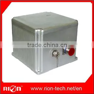
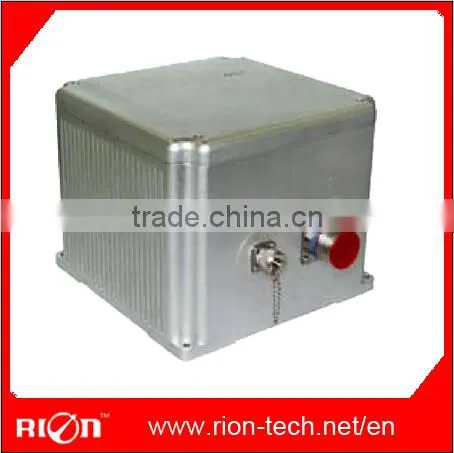
Size |
151×120×101mm |
||
Weight |
<3Kg |
||
Description
NV-GI510 Tightly integrated system applies tight integration technology to combine high sensitivity, professional level, multi-channel single frequency carrier phase and pseudo range data of GPS receiver with high accuracy quartz accelerometer and FOG based Inertial Measurement Unit (IMU). The system achieves small size, light weight and good performance-price ratio.
NV-GI510 navigation system provides attitude information of horizontal attitude and heading, provides positioning information of longitude, latitude and height, also provides 3D acceleration and angular rate, etc. It can be extended to GLONASS and further improve its measurement accuracy and applicability by assisting with speedometer and altimeter sensors etc. The extended system can be widely applied in ground, marine as well as aviation areas to provide powerful synergistic Guidance, Navigation & Control (GN&C).
Features
- Tightly integrated INS/GPS
- Low-cost, light-weight
- Complete sealed rugged design to protection
- against harsh environment
- Vibration and EMI resistance
- Differential GPS capability (optional)
- GLONASS capability (optional)
- Extension with speedometer, and altimeter
- sensors (optional)
Application
- Aviation
- Long-haul Transportation
- Vehicle Guidance and Control
- Attitude Reference
- Marine Dynamics
- Mining and Auto-farming
- Train & Container Tracking

Send Inquiry to This Supplier

You May Also Like
-
Rugged Housing Inclination Indicator Sensor MEMS Dual Axis Level SensorNegotiableMOQ: 1 Piece
-
High Performance 3-Axis Digital Compass for Drilling MeasurementNegotiableMOQ: 1 Piece
-
Cheap LCD Bevel With Night VersionNegotiableMOQ: 1 Piece
-
Heading Measurement Magnetic Compass Module Digital OutputNegotiableMOQ: 1 Piece
-
Level Security Alarm and Platform Leveling Detection Rugged Electronic Tilt-switches Direct Lead CableNegotiableMOQ: 1 Piece
-
Waterproof Tilt Sensor Canopen/CAN2.0 High Repeatability in Wide Temp.NegotiableMOQ: 1 Piece
-
Dual Axis Digital Inclinometer MEMS Industrial Level SensorNegotiableMOQ: 1 Set
-
Double Benchmark Strong Magnet Installation 2-Axis Digital Display Precision Levelling InstrumentNegotiableMOQ: 1 Set
-
LCD Screen Sound Reminding Digital Level Hand ToolNegotiableMOQ: 1 Piece
-
Fast Response Data Storage Low Cost Dual Axis LCD Digital Level IndicatorNegotiableMOQ: 1 Piece


