GNSS positioning rtk gps with high accuracy
- 1000 Set / Sets per Month
- Chongqing Qingdao Shanghai
- T/T Credit Card

You May Like
-
 Competitive gps equipment with good quality
-
GPS Module with WIFI,Bluetooth,3G RTK GPS Positioning
-
RTK measuring or Static measuring Hi target H32 GPS GNSS Base and Rover receiver
-
New condition high accuracy mini gps for navigation hand gps
-
Gps Receiver Type and Hand Held Use portable GPS
-
CE Certificated 3700mAh GPS Receiver Handheld GPS Navigation
Product Details
| Type | Gps Navigator | Use | Hand Held | |
| Screen Size | 3.5 inch | Function | Bluetooth-enabled, Mp3/Mp4, Photo Viewer, Touch Screen, Other, Bluetooth-enabled, Mp3/Mp4, Photo Viewer, Touch Screen, Surveying and Mapping | |
| Place of Origin | Chongqing, China | Brand Name | Hi-Target RTK GPS | |
| Model Number | V60 RTK GPS | Warranty | 12 Months |
Product Description
V60 GNSS RTK GPS
This kind of New Nevigation RTK GPS navigation equipment is widely used in surveying and mapping in engineering construction and geological.For it's advantages of the good qualilty,competitive price,high precision,light weight...,it's popular in the market.
The New RTK Nevigation GPS is a more compact-design and higher-performance GNSS RTK system, besides its rugged design to resist impact and vibration. The V60 has industrial OLED display screen on its front control panel to show all information and status of the work. With the smart speaker inside the receiver, the DIY guiding voice can be customized in any language, even dialect! 1GB internal storage plus 8GB Micro SD card memory is standard, the V60 supports up to 32GB extension of memory. The V60 is fully compatible with other GNSS RTK receivers from the world market. The static data can be saved directly in RINEX format.
*Technical Specification of Our RTK GPS:
| Measurements | 220 channels | |
| Advanced Pacific Crest Maxwell 6 Custom Survey GNSS Technology | ||
| High precision mulciple correlator for GNSS pesudo range | ||
| Unfiltered,low noice,low multipath error,low time domine correlation | ||
| Very low noise GNSS carrier phase measurements with<1mm precision(1 Hz) | ||
| Signal-to-Noise ratio reprted in dB-Ha | ||
| Proven Pacific Crest low elevation travking technology | ||
| Satellite Singnals Tracked | GPS: L1C/A,L2C,L2E,L5 | |
| Simultaneously | GLONASS: L1C/A,L1P,L2C/A(GLONASS M only),l2p | |
| SBAS: L1 C/A,L5 | ||
| Galileo: L1 BOC,E5A,E5B,E5ALtBOC | ||
| BDS/Compass: B1,B2 | ||
| QZSS: L1 C/A, L1 SAIF,L2C,L5 | ||
| Positioning performance | Static and Fast Static | Horizonta:l2.5mm+0.5ppm RMS |
| GNSS surveying | Vertica:l5mm+0.5ppm RMS | |
| Post Processing Kinematic | Horizontal:1cm+1ppm RMS | |
| (PPK/Stop&Go) GNSS surveying | Vertical:2.5cm+1ppm RMS | |
| Initialization time:typically 10 minutes | ||
| For base while 5 minutes for rover | ||
| Initialization reliability:typically>99.9% | ||
| Realtime Kinematic(RTK) surveying | Horizontal.8mm+1ppm RMS | |
| Vertical.15mm+1ppm RMS | ||
| Initialization timetypically < 8seconds | ||
| Initialization reliability.typically > 99.9% | ||
| Code Differential GNSS postioning | Horizontal.25cm+1ppm RMS | |
| Vertical.50cm+1ppm RMS | ||
| SABS:0.50m Horizontal, 0.85m Vertical | ||
| Hardware | Physical | Dimensions(W × H):18.20cm×9.80cm(7.17 in.×3.86 in.) |
| Weight:1.25kgs(2.76lbs)without internal battery | ||
| Operating:-45°C to+65°C(-49°F to+149°F) | ||
| Storage temperature.-55°C to+85°C(-67°F to+185°F) | ||
| Humidity:100%,considering | ||
| Water/dustproof.IP67 dustproof,protected from | ||
| Temporary immersion to depth of 1 m(3.28ft) | ||
| Shock and Vibration.Designed to survive | ||
| a 3m(9.84ft) nature fall onto contrete. | ||
| Electrical | Power 6V to 28V DC external power input | |
| Power consumption ≤3.5w | ||
| Automatic Switching between internal power and external power | ||
| Rechargeable, removable 7.4V,5000mAh Lithium-Ion | ||
| Battery in internal battery compartment | ||
| Internal battery life | Static 13-15 hours | |
| RTK Rover(UHF/GPRS/3G)10-12 hours | ||
| RTK Base 8-10 hours | ||
| I/O interface | 1×Bluetooth | |
| 1×standard USB2.0 port | ||
| 1×TNC UHF connector | ||
| 2×RS232 serial port | ||
| 2×DC power input(8-pin & 5-pin) | ||
| 1×Micro SD card port | ||
| Communication and data storage | 3G Communication | Fully integrated, fully sealed internal 3G, |
| compatabile with GPRS | ||
| Network RTK(via CORS) range 20-50km | ||
| HI-TRAGERT internal UHF radio(standard) | Frequency:450~470MHz with 116 channel | |
| Transmitting Power:1W,2W,5W,adjustable | ||
| Transmitting Speed:9.6Kbps,19.2Kbps | ||
| Working Range:5km typical,8-10km optimal | ||
| Pacticic Crest XDL Micro internal UHF RADIO | Frequency:403-473MHz | |
| Transmitting Power:0.5W,2W adjustable | ||
| Transmitting Speed:Up to 19.2Kbps | ||
| Working Range:3-5km typical,8-10km optimal | ||
| Hi—Target external UHF radio(standard) | Frequency:460MHz with 116 channels | |
| Transmitting Power:5W,10W,20W,30W adjustable | ||
| Transmitting Speed:Up to 19.2Kbps | ||
| Working Range:8-10km typical,15-20km optimal | ||
| Pacific Crest ADL vantage Pro External UHF radio | Frequency:390-430MHz or 430-470MHz | |
| Transmitting Power:4W to 35W adjustable | ||
| Transmitting Speed:Up to 19.2Kbps | ||
| Working Range:8-10km typical,15-20km optimal | ||
| Support other external Communication device | For example, external GSM moderm. | |
| Data formats | CMR:sCMRx,CMR, CMR+ input and output | |
| RTCM:RTCM2.1 2.2 2.3 3.0 3.1 3.2 input and output | ||
| Navigation outputs ASCII:NMEA-0183 | ||
| Navigation outputs Binary:GSOF | ||
| 1 Pules Per Second Output | ||
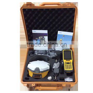
*Pictures of Main Configuration:
*Advantages of Our RTK GPS:
1.The GPS machine enjoys a high precision;
2.The GPS machine is cheap and fine;
3.12 monthes warenty;
4.Thoughtful after-sales service and powerful technical support.
*Main Application of Our RTK GPS:
*Construction Lofting;
*Electric power transportation;
*CORS application;
*CORS site building;
*Control survey;
*Data collection;
*Measurment under water;
*Construction and position.
*Packaging:
The GPS are packaged with plastic box inside and carton box outside,1PC/Carton;
*Delivery:
We will arrange delivery within 7 working days.
*Short Introduce of Our Company:
Chongqing Gold Mechanical & Electrical Equipment Co.,Ltd is a high-tech enterprise for researching,designing,developing and producing oil treatment equipment.With it’s continuous drawing of lessons,unremitting innovation and borrowing of advanced technology from both at home and abroad,our company is now becoming a professional manufacturer of surveying and mapping equipments,such as GPS,Total Station,Drilling rigs and so on. All of our products are excellent in quality.Though highly acclaimed and favorably accepted by numerous customers and possessed of the right to import and export,to insure the high quality of our products,we conduct our manufacturing in strict axxordance with the highest srandard we can do.
We have persisted on the business idea of “Integrity Basis and Quality First” for the stable and constant development.We are making effort to develop together with customers from both domestic and abroad on the basis of reciprocity.Client,quality and service are our supreme target.
Contact us:
Contact Us
- Chongqing Huobo Surveying Instruments Co., Ltd.
- Contact nameMichelle Li Chat Now
- Phone0086-023-62794421
- AddressNo. 7-8, No. 23, Nanping West Road, Nanping Street
Product Categories
| Drilling Rig | Mapping GIS | New Products | Surveying |
New Products
-
Survey Equipment Supplier in China High quality cheap Total Station
-
Hot sale:High accuracy total station surveying instrument
-
100% Original Hi-target Total Station with high accuracy
-
New condition survey equipment ZTS-320/R Total Station
-
Water Well Camera and Borehole Camera, Factory directly Sale BORE WELL INSPECTION CAMERA
-
Underwater deep water well inspection camera 360 degree rotation underground borehole inspection camera
-
Inspection Camera for Boreholes/Water Well /Sewers, Deep Well Inspection System
-
GYGD Groundwater Inspection using Down the Waterproof Borehole Camera
-
Water Well Wall 360 degree Inspection Camera , Borehole Video Inspection system for sale
-
Boreholes for Water Wells, Borehole drilling CCTV Camera System
-
Bore hole inspection cctv water well camera
-
Downhole Video Inspection Camera 75mm Diameter Waterproof Camera Borehole Inspection
-
Focus Adjustable Downhole Television Rotating Borewell Inspection CCTV System
-
Panoramic Borehole Full-view Inspection Television Underwater Camera
-
Focus Adjustable Borewell Inspection Camera Rotating Downhole Camera
-
Borewell Inspection Camera Downhole Underwater Inspection Camera System
-
Wide Angle Lens Borehole Television Underwater Camera Well Inspection System
-
Panoramic Lens Borehole Inspection Television Water-proof Camera
-
Rotating Lens Borehole Television Underwater Well Inspection Camera System
-
Electric Rotating Lens Borewell Camera Underwater Inspection Camera System
-
Electric Rotating Borehole Inspection Television Waterwell Inspection Camera
-
Full View Borehole Inspection Television Water-proof Camera Well Camera System
-
Electric Rotating Borehole Television Water Well Inspection CCTV System
-
360 Degree Electric Rotating Borehole Television Well Water-proof Inspection Camera
Popular Searches
- satellite
- gsm
- gps navigator
- gps navigation box
- gps chipset
- car gps
- box gps car navigation
- vehicle device
- call logger
- gps tracker
- car tracker
- Gps Car Alarm
- Tracking Car Alarm
- gps navigation
- car navigation
- gps navigation system
- Car Gps Tracker
- Gps Tracking System
- Gps Vehicle Tracking System
- Gps Map
- mini antenna satellite
- sim card backup
- car gps navigation
- Navigation & GPS
- gps system
- navigator
- gps device
- portable gps
- Car Navigation Gps
- Tracker Gps
Recommended Products
- Original SMC IP200-120 cylinder positioner New original authentic
- Hi Target GPS V200 GNSS RTK Receiver with tilt sensor
- Hi Target GPS V200 GNSS RTK Receiver with tilt sensor
- 4 Channel HD Mobile DVR 1080P Public Bus Truck Mdvr GPS 3G 4G Mobile DVR
- Full HD HDD 8CH 1080P DVR para vigilância por vídeo de segurança de veículos
- 107M Series (Type A, Type B, Type C, Type D) Double Antenna Combination Micro Inertial Measurement System
- 105M Series (Type A, Type B, Type C, Type D) Single Antenna Combination Micro Inertial Measurement System
- INS1200 Series Fiber Optic GNSS/INS Integrated Inertial Navigation System of Type A, Type B, Type C, and Type D
- INS900 Series Fiber Optic GNSS/INS Integrated Inertial Navigation System of Type A, Type B, Type C, and Type D
- INS600 Series Fiber Optic GNSS/INS Integrated Inertial Navigation System of Type A, Type B, Type C, and Type D
- INS300 Series Fiber Optic GNSS/INS Integrated Inertial Navigation System of Type A, Type B, Type C, and Type D
- FOG900 Series A-type, B-type, C-type, D-type Fiber Optic Gyroscope
Find Similar Products By Category
- Electrical & Electronics > GPS > GPS Navigator
- Please Enter your Email Address
- Please enter the content for your inquiry.
We will find the most reliable suppliers for you according to your description.
Send Now-
 Michelle Li
Welcome to my shop, I'm glad to serve you. Please feel free to send me any questions you may have.
Michelle Li
Welcome to my shop, I'm glad to serve you. Please feel free to send me any questions you may have.
Your message has exceeded the limit.
- Contact supplier for lowest price
- Customized Request
- Request Sample
- Request Free Catalogs
Your message has exceeded the limit.
-
Purchase Quantity
-
*Sourcing Details
Your inquiry content must be between 10 to 5000 characters.
-
*Email
Please enter Your valid email address.
-
Mobile