V60 Survey GNSS RTK GPS System
- 1000 Set / Sets per Month
- Chongqing Qingdao Shanghai
- T/T

You May Like
Product Details
| Type | Gps Navigator | Use | Hand Held | |
| Screen Size | 3.5 inch | Function | Bluetooth-enabled, Mp3/Mp4, Photo Viewer, Radio Tuner, Touch Screen, Other, Bluetooth-enabled, Mp3/Mp4, Photo Viewer, Radio Tuner, Touch Screen, Surveying and Mapping | |
| Place of Origin | Chongqing, China | Brand Name | Hi-Target | |
| Model Number | V60 GNSS RTK GPS | Warranty | 12 Months |
Product Description
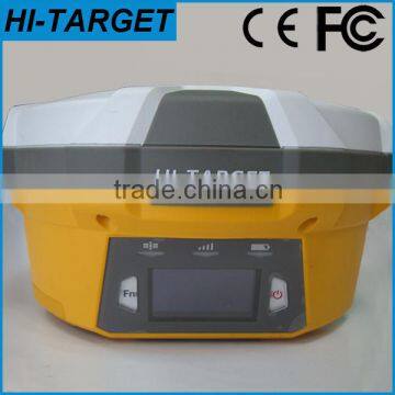
V60 GNSS RTK GPS
This kind of RTK GPS navigation equipment is widely used in surveying and mapping in engineering construction and geological.For it's advantages of the good qualilty,competitive price,high precision,light weight...,it's popular in the market.
The New RTK GPS is a more compact-design and higher-performance GNSS RTK system, besides its rugged design to resist impact and vibration. The V60 has industrial OLED display screen on its front control panel to show all information and status of the work. With the smart speaker inside the receiver, the DIY guiding voice can be customized in any language, even dialect! 1GB internal storage plus 8GB Micro SD card memory is standard, the V60 supports up to 32GB extension of memory. The V60 is fully compatible with other GNSS RTK receivers from the world market. The static data can be saved directly in RINEX format.
*Technical Specification of Our V60 RTK GPS:
Measurement:
• 220 Channels
• Advanced Pacific Crest Maxwell 6 Custom Survey GNSS Technology
• High precision multiple correlator for GNSS pseudo range measurements
• Unfiltered, unsmoothed pseudo range measurements data for low noise, low multipath error, low time domain correlation and high dynamic response
• Very low noise GNSS carrier phase measurements with <1 mm precision in a 1 Hz bandwidth
• Signal-to-Noise ratios reported in dB-Hz
• Proven Pacific Crest low elevation tracking technology
Satellite signals tracked simultaneously
GPS: Simultaneous L1C/A, L2C, L2E, L5
GLONASS: Simultaneous L1C/A, L1P, L2C/A (GLONASS M only), L2P
SBAS: Simultaneous L1 C/A, L5
Galileo: Simultaneous L1 BOC, E5A, E5B, E5AltBOC
BDS/Compass: B1, B2
QZSS: L1 C/A, L1 SAIF, L2C, L5
Positioning Pedrformance
Static and Fast Static GNSS surveying
Horizontal: 2.5mm+0.5ppm RMS
Vertical: 5mm+0.5ppm RMS
Post Processing Kinematic
(PPK / Stop & Go) GNSS surveying
Horizontal: 1cm+1ppm RMS
Vertical: 2.5cm+1ppm RMS
Initialization time: typically 10 minutes for base while 5 minutes for rover
Initialization reliability: typically > 99.9%
Real time Kinematic (RTK) surveying
Horizontal: 8mm+1ppm RMS
Vertical: 15mm+1ppm RMS
Initialization time: typically < 8 seconds
Initialization reliability: typically > 99.9%
Code Differential GNSS positioning
Horizontal: 25cm+1ppm RMS
Vertical: 50cm+1ppm RMS
SBAS: 0.50m Horizontal, 0.85m Vertical
Hardware
Physical
Dimensions (W x H): 18.20cm x 9.80cm (7.17 in x 3.86 in)
Weight: 1.25kg (2.76lb) without internal battery
Operating temperature: -45℃ to +65℃ (-49℉ to +149℉)
Storage temperature: -55℃ to +85℃ (-67℉ to +185℉)
Humidity: 100%, considering
Water/dustproof: IP67 dustproof, protected from temporary immersion to depth of 1m (3.28ft).
Shock and Vibration: Designed to survive a 3m (9.84ft) natural fall onto concrete.
Electrical
Power 6V to 28V DC external power input
Power consumption ≤3.5W
Automatic Switching between internal power and external power
Rechargeable, removable 7.4V, 5000mAh Lithium-Ion battery in internal battery compartment
Internal battery life
Static 13 - 15 hours
RTK Rover (UHF/GPRS/3G) 10 - 12 hours
RTK Base 8 - 10 hours
I/O interface
1 x Bluetooth
1 x standard USB2.0 port
1 x TNC UHF connector
2 x RS232 serial port
2 x DC power input (8-pin & 5-pin)
1 x Micro SD card port
Communication and data storage
3G Communication
Fully integrated, fully sealed internal 3G, compatible with GPRS
Network RTK (via CORS) range 20-50km
HI-TARGET internal UHF radio (standard)
Frequency: 450~470MHz with 116 channels
Transmitting Power: 1W, 2W, 5W adjustable
Transmitting Speed: 9.6Kbps, 19.2Kbps
Working Range: 5km typical, 8~10km optimal
Pacific Crest internal UHF radio
Frequency: 403~473 MHz
Transmitting Power: 0.5W, 2W adjustable
Transmitting Speed: Up to 19.2Kbps
Support most of radio communication protocol
Working Range: 3~5km typical, 8~10km optimal
HI-TARGET External UHF radio (standard)
Frequency: 460 MHz with 116 channels
Transmitting Power: 5W, 10W, 20W, 30W adjustable
Transmitting Speed: Up to 19.2Kbps
Working Range: 8~10km typical, 15~20km optimal
Pacific Crest ADL Vantage Pro External UHF radio
Frequency: 390~430 MHz or 430~470 MHz
Transmitting Power: 4W to 35W adjustable
Transmitting Speed: Up to 19.2Kbps
Support most of radio communication protocol
Working Range: 8~10km typical, 15~20km optimal
Support other external communication device
For example, external GSM modem.
Data storage
1GB Internal storage+ 8GB Internal Micro SD Card memory (Support up to 32GB extension)
Record GNS and Rinex format simultaneously.
*Pictures of Main Configuration of V60 GNSS RTK GPS:

*Main Applications of HI-TARGET GNSS RTK GPS:
Commercial and Residential Subdivisions
- Provide a complete survey package from the preliminary planning stage all the way to plan completion and registration
- Ensure that proposed subdivisions meet bylaw regulations and community planning requirements
Right of Way Surveys
- Utility and feature right of ways
- Road right of ways
- Route planning
- Pre-Construction surveys
- Boundary demarcation and area determination
- Plan Completion and registration
Construction Surveys
- Basement stakeouts
- Elevation certificates
- Pile layout
- Foundation layout
Real Property Reports
- Referencing permanent structures to property boundaries
- Title and easement search
Property Corner Re-Establishments and Boundary Line Identification
- Rural and urban survey services
Contact us:
Contact Us
- Chongqing Huobo Surveying Instruments Co., Ltd.
- Contact nameMichelle Li Chat Now
- Phone0086-023-62794421
- AddressNo. 7-8, No. 23, Nanping West Road, Nanping Street
Product Categories
| Drilling Rig | Mapping GIS | New Products | Surveying |
New Products
-
Modern Designed V60 RTK GPS/GLONASS + GPS+ BDS Survey GPS
-
International Selling China Popular Brand Hi-Target RTK GPS
-
Surveying and mapping builings,roads construction GPS RTK GLONASS,GPS,SBAS
-
Cheap and fine V60/V30 rtk gps with famous brand
-
Modern design new condition Hi-target total station for sale
-
Fashion and practical rtk gps with Linux operation operation system
-
High accuracy electronic GNSS RTK GPS
-
GNSS positioning rtk gps with high accuracy
-
Competitive gps equipment with good quality
-
GPS Module with WIFI,Bluetooth,3G RTK GPS Positioning
-
RTK measuring or Static measuring Hi target H32 GPS GNSS Base and Rover receiver
-
New condition high accuracy mini gps for navigation hand gps
-
Gps Receiver Type and Hand Held Use portable GPS
-
CE Certificated 3700mAh GPS Receiver Handheld GPS Navigation
-
Survey Equipment Supplier in China High quality cheap Total Station
-
Hot sale:High accuracy total station surveying instrument
-
100% Original Hi-target Total Station with high accuracy
-
New condition survey equipment ZTS-320/R Total Station
-
Water Well Camera and Borehole Camera, Factory directly Sale BORE WELL INSPECTION CAMERA
-
Underwater deep water well inspection camera 360 degree rotation underground borehole inspection camera
-
Inspection Camera for Boreholes/Water Well /Sewers, Deep Well Inspection System
-
GYGD Groundwater Inspection using Down the Waterproof Borehole Camera
-
Water Well Wall 360 degree Inspection Camera , Borehole Video Inspection system for sale
-
Boreholes for Water Wells, Borehole drilling CCTV Camera System
Popular Searches
- satellite
- gsm
- gps navigator
- gps navigation box
- gps chipset
- car gps
- box gps car navigation
- vehicle device
- call logger
- gps tracker
- car tracker
- Gps Car Alarm
- Tracking Car Alarm
- gps navigation
- car navigation
- gps navigation system
- Car Gps Tracker
- Gps Tracking System
- Gps Vehicle Tracking System
- Gps Map
- mini antenna satellite
- sim card backup
- car gps navigation
- Navigation & GPS
- gps system
- navigator
- gps device
- portable gps
- Car Navigation Gps
- Tracker Gps
Recommended Products
- Original SMC IP200-120 cylinder positioner New original authentic
- Hi Target GPS V200 GNSS RTK Receiver with tilt sensor
- Hi Target GPS V200 GNSS RTK Receiver with tilt sensor
- 4 Channel HD Mobile DVR 1080P Public Bus Truck Mdvr GPS 3G 4G Mobile DVR
- Full HD HDD 8CH 1080P DVR para vigilância por vídeo de segurança de veículos
- 107M Series (Type A, Type B, Type C, Type D) Double Antenna Combination Micro Inertial Measurement System
- 105M Series (Type A, Type B, Type C, Type D) Single Antenna Combination Micro Inertial Measurement System
- INS1200 Series Fiber Optic GNSS/INS Integrated Inertial Navigation System of Type A, Type B, Type C, and Type D
- INS900 Series Fiber Optic GNSS/INS Integrated Inertial Navigation System of Type A, Type B, Type C, and Type D
- INS600 Series Fiber Optic GNSS/INS Integrated Inertial Navigation System of Type A, Type B, Type C, and Type D
- INS300 Series Fiber Optic GNSS/INS Integrated Inertial Navigation System of Type A, Type B, Type C, and Type D
- FOG900 Series A-type, B-type, C-type, D-type Fiber Optic Gyroscope
Find Similar Products By Category
- Electrical & Electronics > GPS > GPS Navigator
- Please Enter your Email Address
- Please enter the content for your inquiry.
We will find the most reliable suppliers for you according to your description.
Send Now-
 Michelle Li
Welcome to my shop, I'm glad to serve you. Please feel free to send me any questions you may have.
Michelle Li
Welcome to my shop, I'm glad to serve you. Please feel free to send me any questions you may have.
Your message has exceeded the limit.
- Contact supplier for lowest price
- Customized Request
- Request Sample
- Request Free Catalogs
Your message has exceeded the limit.
-
Purchase Quantity
-
*Sourcing Details
Your inquiry content must be between 10 to 5000 characters.
-
*Email
Please enter Your valid email address.
-
Mobile