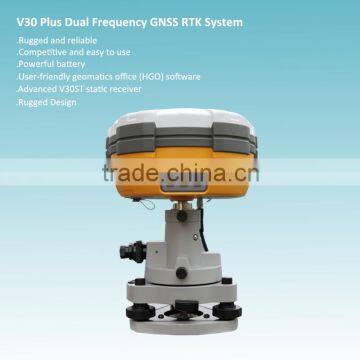


High-performance RTK GPS System For Field Surveying
- 100 Set / Sets per Month
- Chongqing China
- T/T

You May Like
-
 Intelligent Calibration Software Applied Absolute Encoding Total Station
-
Absolute Encoding Upward Laser Pointing Total Station
-
Compact, Lightweight Design Absolute Encoding Total Station
-
Dual Axis Compensation Absolute Encoding Total Station
-
Microsoft Windows Mobile 6.5 operating system Hi-Target Qmini MP Field Controller
-
Full Satellites Singal Simultaneously Tracked RTK GPS Survey System
Product Details
| Type | Gps Receiver | Use | Automotive | |
| Screen Size | Other | Function | Bluetooth-enabled | |
| Place of Origin | Chongqing, China | Brand Name | Hi-target | |
| Model Number | V30 | Warranty | 1 Years |
Product Description
High-performance RTK GPS System For Field Surveying
1. Construction Layout
2. Electric power transportation
3. CORS application
4. CORS site
5. Control survey
6. Data collection
7. Water Measurement
8. Construction Positioning (water)
Multi-constellation tracking
1. This RTK GPS has 220 tracking channels.
2. Supports GPS, GLONASS, GALILEO, BDS, SBAS.
3. NGS approved GNSS antenna.
Intelligent operation
1. Equipped with a smart speaker guiding the whole operation.
2. Multi one-button functions make fieldwork easier, such as auto
base setup by one button, the rover can get fix solution once it
is turned on.
Diversify RTK application
Optional transceiver UHF radio
1. The transceiver UHF radio enables the working mode to be
switchable between base and rover.
2. 2-watt HI-TARGET internal UHF radio and 2-watt Pacific Crest
TrimTalk© internal UHF radio are optional. Pacific Crest TrimTalk©
internal UHF radio is compatible with other radios.
3. Removable internal UHF radio enables users to fix or exchange
simply.
Seamless operation in CORS system
4.Built-in GPRS/GSM/3G module ensures that the V30 works
perfectly with network RTK positioning.
Long-life battery
1. Powered by 5000mAh Li-ion battery.
2. Static working time 13 - 15 hours.
3. RTK Rover (UHF/GPRS/GSM) working time 10 - 12 hours.
4. RTK Base working time 8 - 10 hours.
Rugged and unique design
1. IP67 dust/water protection.
2. Withstands 3-meter natural fall onto concrete.
3. Rapid tracking and perfect avoidance or reduction of obstruction
and multipath effect to ensure superior positioning capability.
Static receiver | V30 | |
Channel | 220 | |
Signal tracking | GPS | L1 C/A, L2E, L2C, L5 |
| Glonass | L1C/A, L1P, L2C/A, L2P |
| SBAS | L1C/A, L5 |
| BDS | B1,B2 |
Bluetooth | YES | |
Positioning accuracy | Static and Fast Static GNSS surveying Horizontal: ±(2.5mm+1ppm RMS); Vertical: ±(5mm+1ppm RMS) | |
| Post processing Kinematic(PPK/Stop & Go)GNSS surveying Horizontal: ±(1cm+1ppm RMS); Vertical: ±(2.5cm+1ppm RMS) Initialization time: typical 10 minutes for base while 5 minutes for rover Initialization reliability:typical>99.9% | |
Baseline length | Static: 30-40km for low latitude area; up to 100km Fast Static: <20km; Stop & Go: <20km; PPK: <15km | |
Data storage | 1GB | |
Data download | COM/USB | |
Interval | 1s-60s adjustable | |
Elevation | 1°-60° adjustable | |
Data update rate | 1-50hz | |
Communications | 2 RS-232 port; 1 USB port; 1 bluetooth port; 2 external DC power input port | |
Dimension | 19.5cm * h10.4cm | |
Weight (with battery) | 1.3kg (incl.battery) | |
Water/dust proof | IP67, 3m(9.84ft) natural fall onto concrete | |
Working temperature | -40℃~+65℃ | |
Storage temperature | -40℃~+75℃ | |
Electrical | 2 pcs 7.4v 5000mAh lithium battery, supports 6-28v external DC power supply | |
| Power consumption 3.2W | |
| Working time 13-15 hours | |
Software | Relevant software provided | |
Any question, feel free to contact:
Contact Us
- Chongqing Huobo Surveying Instruments Co., Ltd.
- Contact nameMichelle Li Chat Now
- Phone0086-023-62794421
- AddressNo. 7-8, No. 23, Nanping West Road, Nanping Street
Product Categories
| Drilling Rig | Mapping GIS | New Products | Surveying |
New Products
-
Professional Millimeter Level High Precision RTK GPS Survey System
-
Multi-satellite Millimeter Level RTK Surveying And Mapping Instrument
-
High Precision RTK GNSS Instrument For Topographic Surveying
-
Civil Land Surveying Design RTK GPS System
-
Multi-constellation Tracking RTK GPS Surveying System
-
High Precision RTK GPS Land Surveying System
-
Multi Satellite Signal Receiving RTK GNSS System
-
220 Channels Dual Frequency RTK GPS Surveying System
-
Topographic Differential Signal Receiving RTK GPS System
-
High Accuracy GNSS RTK System With Competitive Price
-
High Accuracy Dual Frequency GNSS RTK System
-
GPS model dual frequency H32 GNSS RTK GPS for Sale
-
Special design cheap and fine H32 RTK GPS with CE certification
-
High accuracy engineering construction survey instrument rtk gps
-
HI-TARGET H32 GNSS RTK System,H32 RTK GPS
-
Portable universal control bluetooth satellite receiver surveying equipment
-
Portable universal control bluetooth satellite receiver with android handheld device
-
GPS Surveying Instrument HI TARGET V90 PLUS RTK GPS GNSS RTK
-
V30 hi-target gps receiver antenna measuring instruments
-
V60 Portable hi-target bluetooth gps receiver with android handheld device
-
Dual Frequency RTK GPS Base For RTK Surveying System
-
High Accuracy RTK GPS Rover For RTK GPS Survey System
-
Reflectorless (optional) Land Surveying Total Station
-
Dual-axis Compensating Available Robotic Total Station
Popular Searches
- satellite
- gsm
- gps navigator
- gps navigation box
- gps chipset
- car gps
- box gps car navigation
- vehicle device
- call logger
- gps tracker
- car tracker
- Gps Car Alarm
- Tracking Car Alarm
- gps navigation
- car navigation
- gps navigation system
- Car Gps Tracker
- Gps Tracking System
- Gps Vehicle Tracking System
- Gps Map
- mini antenna satellite
- sim card backup
- car gps navigation
- Navigation & GPS
- gps system
- navigator
- gps device
- portable gps
- Car Navigation Gps
- Tracker Gps
Recommended Products
- Original SMC IP200-120 cylinder positioner New original authentic
- Hi Target GPS V200 GNSS RTK Receiver with tilt sensor
- Hi Target GPS V200 GNSS RTK Receiver with tilt sensor
- 4 Channel HD Mobile DVR 1080P Public Bus Truck Mdvr GPS 3G 4G Mobile DVR
- Full HD HDD 8CH 1080P DVR para vigilância por vídeo de segurança de veículos
- 107M Series (Type A, Type B, Type C, Type D) Double Antenna Combination Micro Inertial Measurement System
- 105M Series (Type A, Type B, Type C, Type D) Single Antenna Combination Micro Inertial Measurement System
- INS1200 Series Fiber Optic GNSS/INS Integrated Inertial Navigation System of Type A, Type B, Type C, and Type D
- INS900 Series Fiber Optic GNSS/INS Integrated Inertial Navigation System of Type A, Type B, Type C, and Type D
- INS600 Series Fiber Optic GNSS/INS Integrated Inertial Navigation System of Type A, Type B, Type C, and Type D
- INS300 Series Fiber Optic GNSS/INS Integrated Inertial Navigation System of Type A, Type B, Type C, and Type D
- FOG900 Series A-type, B-type, C-type, D-type Fiber Optic Gyroscope
Find Similar Products By Category
- Electrical & Electronics > GPS > GPS Navigator
- Please Enter your Email Address
- Please enter the content for your inquiry.
We will find the most reliable suppliers for you according to your description.
Send Now-
 Michelle Li
Welcome to my shop, I'm glad to serve you. Please feel free to send me any questions you may have.
Michelle Li
Welcome to my shop, I'm glad to serve you. Please feel free to send me any questions you may have.
Your message has exceeded the limit.
- Contact supplier for lowest price
- Customized Request
- Request Sample
- Request Free Catalogs
Your message has exceeded the limit.
-
Purchase Quantity
-
*Sourcing Details
Your inquiry content must be between 10 to 5000 characters.
-
*Email
Please enter Your valid email address.
-
Mobile