


Hi-Target V60 GPS RTK 220 Channel Tracking GNSS Receiver
- Shanghai
- T/T Credit Card
You May Like
-
 High Quality Dual-frequency GPS WIFI Surveying Hi-Target V60 GPS RTK System
-
GPS GLONSS Receiver RTK System for Land Survey and Geodetic Survey
-
DUAL FREQUENCY H32 GNSS RTK HI TARGET GPS RTK Topographic Equipment
-
V30 GPS+GLONSS+ BDS High Positioning Accuracy and Stable Working Performance
-
Best GPS RTK System of Hi-Target V30 GPS RTK for Land Surveying
-
HI-TARGET GPS RTK External UHF Radio for Sale
Product Details
| Type | Gps Navigator | Use | Automotive | |
| Screen Size | 2.5 inch | Function | Bluetooth-enabled, Mp3/Mp4, Radio Tuner | |
| Place of Origin | Chongqing, China | Brand Name | Hi-Target | |
| Model Number | V60 | Warranty | 1 Years |
Product Description
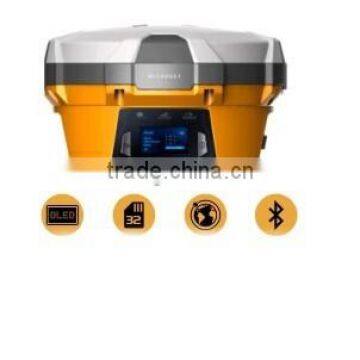
Hi-Target V60 GNSS RTK System
The V60 features with a more compact-design and higher-performance GNSS RTK system, and also it has rugged design to resist impact and vibration. With the smart speaker inside the receiver, the DIY guiding voice can be customized in any language, even dialect! The V60 has industrial OLED display screen on its front control panel to show all information and status of the work. The V60 is fully compatible with other GNSS RTK receivers from the world market. The static data can be saved directly in RINEX format.1GB internal storage plus 8GB Micro SD card memory is standard, the V60 supports up to 32GB extension of memory.
Applications:
1.Construction Lay Out
Abundant point and line lay out function, assistant by graph operation instruction, save your expenditure in practical construction.
2.Electricity and Transportation
Friendly function on power line route direction survey, distance survey and angle calculation; comprehensive survey functionality on road survey, center line, offset survey, profile and cross-section survey.
3.CORS Application
Seamlessly compatible with CORS system, only one RTK rover can receive CORS difference signal and carry out data collection, construction lay out work.
4.CORS Station Establishment
HD-CORS apply profound experience and mutual technology, stable on operation, long distance on data transmission, is yur first choice for city continuous reference stations system.
5.Control Survey
Only one investment you can get list of function, v30 dual frequency static survey accuracy can satisfy any requirements, config with mutual professional data solution software. You can easily accomplish various high precision control survey work.
6.Data conllection
Cotroller operation software designed for GIS application, convenient coding function, meets all your requirements in field data collection work.
Our Service
1.Your inquiry related to our products or prices will be replied in 24hrs.
2.Well-trained and experienced staffs to answer all your enquires in fluent English
Partners Meeting in Hi-Target Company
Contact Us
- Chongqing Huobo Surveying Instruments Co., Ltd.
- Contact nameMichelle Li Chat Now
- Phone0086-023-62794421
- AddressNo. 7-8, No. 23, Nanping West Road, Nanping Street
Product Categories
| Drilling Rig | Mapping GIS | New Products | Surveying |
New Products
-
Nice Price RTK GNSS With BDS Tracking Hi-Target V60 GNSS RTK Price
-
Quick Upgrade GNSS RTK Surveying Equipment for Geodetic Surveying Hi-Target V60 GNSS RTK
-
Flexible Flat Cables RTK GPS GNSS Receiver Hi-Target V60 GPS RTK System
-
Hi-Target V30 RTK GPS Geodetic Surveying Equipment Land Survey Instrument
-
Best Selling RTK GPS With Long Working Time 8-10 Hours Survey Device Hi-Target V60 GPS
-
H32 V30 GPS Base Rover GPS RTK System HI TARGET GNSS GPS Receiver
-
Hot Selling Survey Instrument RTK GPS With High Positioning Precision
-
China Brand GPS RINEX Storage GNSS Hi-Target V60 RTK GPS
-
Trimble Mother Board V30 GPS RTK Survey Equipment
-
Hot Selling China Branded Intelligent GPS RTK Hi-Target H32 GNSS RTK
-
Hi-Target V30 RTK System GPS+GLONSS+ BDS in Stable Working Performance and High Positioning Accuracy
-
Latest Navigation System for LAND SURVEY, Topographic Surveys, With RTK GPS V30 HI-Target GNSS RTK
-
35W External UHF Radio for Hi-Target GNSS GPS RTK Survey Instrument
-
GPS NAVIGATION DEVICES HIGH ACCURACY SURVEY EQUIPMENT V30 RTK GPS
-
Hi-target V90 Plus Pro GNSS RTK System Surveying Gps Gnss Rtk System
-
Hi-Target V60 High Accuracy Gps Rtk Gnss Surveying System for Geodata Land Survey
-
Hi-Tech Compact and Smart RTK GPS V90 Plus GNSS RTK System for Geodetic Surveying
-
Hi-target H32 Gnss RTK System and V30 GNSS RTK System for Engineering Location
-
Land Survey Instrument Geodetic Surveying Equipment With Hi-Target V30 GNSS GPS RTK Surveying Equipment
-
Global Positioning System Navigation Apply in Land Surveying Topographic Surveying Construction Layout
-
TILT SURVEY FOR Tilt Angle of 30 Degrees V90 Hi-Target Newest GPS RTK SURVEY GNSS EQUIPMENT
-
GNSS Landing SURVEY System Hi-Target V30 RTK GNSS Cadastral Survey
-
20km Long Working Range China Made Hi-Target GPS RTK External UHF Raido
-
Air Baud Rate 9600 Hi-Target GPS RTK External UHF Raido 35W
Popular Searches
- satellite
- gsm
- gps navigator
- gps navigation box
- gps chipset
- car gps
- box gps car navigation
- vehicle device
- gps tracker
- car tracker
- gps car alarm
- tracking car alarm
- gps navigation
- car navigation
- gps navigation system
- car gps tracker
- gps tracking system
- gps vehicle tracking system
- gps map
- mini antenna satellite
- sim card backup
- car gps navigation
- gps system
- navigator
- gps device
- portable gps
- car navigation gps
- tracker gps
- gps tracking
- marine gps
Recommended Products
- GPS for Children and Elderly, 4G Locator for Children and Babies, Anti Turning Remote Tracking for the Elderly, Anti Loss Pendant, Anti Loss Device
- 4G Wireless GPS Locator, Car Anti-theft Pickup Positioning, Remote Tracking Tracker, Car Mounted Beidou Anti Loss Device
- Original SMC IP200-120 Cylinder Positioner New Original Authentic
- Hi Target GPS V200 GNSS RTK Receiver With Tilt Sensor
- Hi Target GPS V200 GNSS RTK Receiver With Tilt Sensor
- 4 Channel HD Mobile DVR 1080P Public Bus Truck Mdvr GPS 3G 4G Mobile DVR
- Full HD HDD 8CH 1080P DVR Para Vigilância Por Vídeo de Segurança de Veículos
- 107M Series (Type A, Type B, Type C, Type D) Double Antenna Combination Micro Inertial Measurement System
- 105M Series (Type A, Type B, Type C, Type D) Single Antenna Combination Micro Inertial Measurement System
- INS1200 Series Fiber Optic GNSS/INS Integrated Inertial Navigation System of Type A, Type B, Type C, and Type D
- INS900 Series Fiber Optic GNSS/INS Integrated Inertial Navigation System of Type A, Type B, Type C, and Type D
- INS600 Series Fiber Optic GNSS/INS Integrated Inertial Navigation System of Type A, Type B, Type C, and Type D
Find Similar Products By Category
- Electrical & Electronics > GPS > GPS Navigator
- Please Enter your Email Address
- Please enter the content for your inquiry.
We will find the most reliable suppliers for you according to your description.
Send Now-
 Michelle Li
Hi there! Welcome to my shop. Let me know if you have any questions.
Michelle Li
Hi there! Welcome to my shop. Let me know if you have any questions.
Your message has exceeded the limit.
- Contact supplier for lowest price
- Customized Request
- Request Sample
- Request Free Catalogs
Your message has exceeded the limit.
-
Purchase Quantity
-
*Sourcing Details
Your inquiry content must be between 10 to 5000 characters.
-
*Email
Please enter Your valid email address.
-
Mobile