

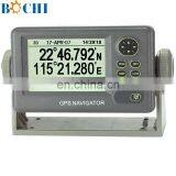
Marine GPS Navigator Of Navigation System


Related Products
-
 Marine Fish Finder GPS Combo For SaleUS$ 200 - 900MOQ: 1 Piece
 -
5.6/8/12 Inch Marine GPS Fish Finder For ShipUS$ 500 - 900MOQ: 1 Set
-
GPS Navigation Equipment Marine Chart PlotterUS$ 300 - 900MOQ: 1 Set
-
5.6 Inch Echo Sounder for FishingUS$ 100 - 1,000MOQ: 1 Set
-
Echo Depth Sounder With GPS For SaleUS$ 200 - 900MOQ: 1 Set
Marine GPS Navigator Of Navigation System
The model is a specially designed for fishing boat, yacht design with SBAS receiver GPS navigator.
It is compact, light, but very precisely correct position, accurate to 15 meters.
In SBAS mode start can be accurate to 3 meters. Has a very high price.
Function description:
1. 4.8 inch silver liquid crystal display (LCD)
2. diverse display mode and can be used for a variety of navigation requirements
3. can store 999 way point, fifty route and 2500 track point
4. a key type way point input
5. users to track memory function storage waypoint for homing, waypoint spacing can be set by the user to
6. way point and line can upload download RS - 232 - c port
spec.
Type | |
Display | 4.5 inch silver liquid crystal display (LCD) |
Precision | GPS 15 meters (95%) SBAS 3 meters (95%) |
Waterproof | Display: IPX5 antenna: IPX6 |
Environment temperature | Display: - 15 °C to 55 °C + 25 °C antenna: - to + 70 °C |
Power | 12 ~ 24 VDC, 240 ~ 120 ma |
Receiver category | GPS: full visual channel 12 parallel processing, C/A code, SBAS receiver |
Receiver frequency | L1 (1575.42 MHz) |
First positioning time | Average 15 seconds (hot boot) |
Tracking speed | 999 kt |
The world coordinate system | WGS - 84. |
Diagonal | 95 (width) x 63 mm (high) LCD |
Pixel lattice | 240 x 160 |
Display mode | Drawing, highways, steering, odometer, navigation material, 2 personalized navigation display |
Memory capacity | 2500 track points, 999 route point additional comments, fifty route, each route can have 30 way point |
Alarm | Arrived, anchor area monitoring, yaw, speed, time, distance, odometer |
Language | English, Spanish, French, German, Dutch, Italian, Portuguese, Vietnamese, Indonesia wen, Chinese and Thai |
Interface | Output (NMEA 0183 ver 2.0) AAM, APB, BOD, BWC, GGA, GLL. RMB, RMC, VTG, XTE, ZDA |
Equipment list
Display the built-in SBAS receiver |
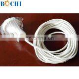
KA - antenna even ten meters cable |
Installation components and spare parts |

Send Inquiry to This Supplier

You May Also Like
-
Caterpillar Excavators, Generator Sets, Marine Engine Exhaust Bellows 214-6045NegotiableMOQ: 1 Unit
-
Cab Fixed Rectangular Window for Marine SuppliesCAD 200 - 200MOQ: 1 Piece
-
Hot Sale High Quality Ship Console With Steering WheelNegotiableMOQ: 1
-
BOCHI Customized Small Boat Front WindscreenUS$ 300 - 380MOQ: 5 Sets
-
Caterpillar 8X-6987 Hydraulic Pneumatic CylinderNegotiableMOQ: 1 Unit
-
Volvo Penta Engine Fuel Injector 21471673NegotiableMOQ: 1 Unit
-
For CAT E345D (K5V212DPH) 295-9663 488-4576 Hydraulic Pump AssemblyNegotiableMOQ: 1 Piece
-
For Excavator Main Pump 5504341 5511118 E336 E340 E345GC K7V180 HydraulicNegotiableMOQ: 1 Piece
-
For Volvo EC550E Hydraulic Main Pump K7V280DTP Piston Pump 14720663NegotiableMOQ: 1 Piece
-
For Cat 349D E349D Excavator 2K5V212DPH Hydraulic Pump Assembly 295-9663 488-4576NegotiableMOQ: 1 Piece

