

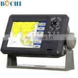
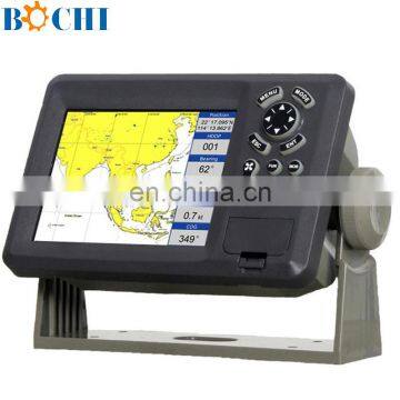
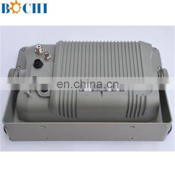
High Resolution 12 Inches Marine GPS


Related Products
-
 Nautical Digital CompassUS$ 500 - 800MOQ: 1 Set
 -
Marine Ship Wholesale Compass With LED LightUS$ 100 - 1,000MOQ: 1 Set
-
220V Navigation Ship Compass With CCS CertificateUS$ 500 - 3,000MOQ: 1 Set
-
Marine Electrical Spade ConnectorsUS$ 1 - 30MOQ: 50 Pieces
-
Nautical Marine Boat CompassUS$ 500 - 800MOQ: 1 Set
High Resolution 12 Inches Marine GPS
Features
Versatile display mode include
Plotter Screen
Nav.Data
Satellite Information
AIS Display
Compass Screen
GOTO track navigation
Map orientation select
Proximity waypoints alarms
Perspective View
Palette
Normal
Daylight – exposed to sunlight
Night – in dark environment
NOAA- paper chart colors
Spec:
PLOTTER CHARACTERISTICS | |
Waypoints/icons |
15,000 waypoints with name, symbol, 10 proximity waypoint |
Routes |
waypoint up to 200 points each, plus MOB and Track Navigation or Goto Track modes |
Tracks |
30,000 point automatic track log; 15 saved track (up to 2000 track points each) let you retrace your path in both directions |
Alarms |
XTE, Anchor drag, arrival, speed, voltage, proximity waypoint and time, AIS alarm. |
Pallete |
1 Normal 2 Daylight exposed to sunlight 3 Night in dark environment NOAA paperchart colors |
Tides |
Tide data |
Projection |
Mercator projection |
Position format |
Lat/Lon |
Base map |
Built-in K-Chart |
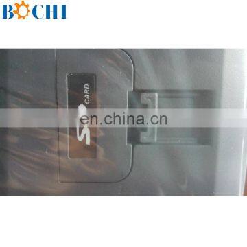
External Map |
SD Cards slot for C-Map MAX |
User data storage |
Internal backup of user settings, or external SD-card |
Plot Interval |
1s to 99h or 0.01 nm to 9.99nm |
Plotting scales |
0.01nm to 1,000nm |
Nav Data |
Inputs: |
Perspective View |
On/off |
POWER SUPPLY |
10.5 to 35VDC, current drain <600mA at 12V |
PHYSICAL | |
Size |
363.8mm(H)X267.9mm(W)X106mm(D) |
Weight |
3.95kg |
Display |
12.1-inches ColorTFT day-view LCD 800 X 600 pixels |
Waterproofing |
Display unit: IPX5 |
Temperature range |
Display unit: -15℃ to +55℃ |
GPS RECEIVER CHARACTERISTICS | |
Receiver |
50 parallel channel GPS receiver continuously Tracks and uses up to 50 satellites to compute and update your position |
Acquisition times |
Cold start: 27 seconds average |
Update rate |
1/second,continuous |
Accuracy |
Position: 2.5 meters(95%) without S/A |
Dynamics |
Altitude: 50,000m Max |
Datum |
WGS 84 & Others |
Interfaces |
NMEA 0183 input and output,RS232 and RS422 output |
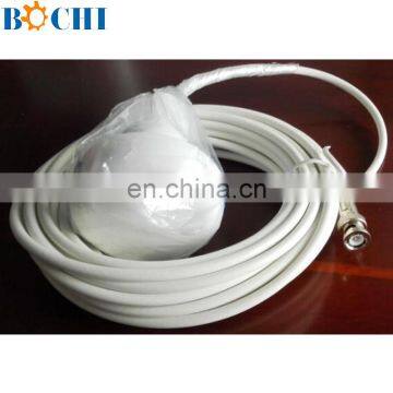
Antenna |
KA07 |
AIS INTERFACE | |
Data input |
NMEA 0183 , RS232 or RS422 |
Baud rate |
38,400 |
EQUIPMENT LIST | |
|
Display unit Antenna unit with 10m cable Operation manual Installation materials and standard spare parts | |

Send Inquiry to This Supplier

You May Also Like
-
Original SMC IP200-120 Cylinder Positioner New Original AuthenticNegotiableMOQ: 1 Piece
-
GPS NavigatorNegotiableMOQ: 2500 Pieces
-
Alarm Monitoring Center Software for Navigation & GPSUS$ 5 - 55MOQ: 1 Piece
-
Analog Capacitive Level Sensor With Stainless Steel ProbeUS$ 40 - 80MOQ: 1 Piece
-
RION-BD982 High Positioning Accuracy GPS Navigation,Can Provide Position Information of Carrier (longitude, Latitude, Height)...NegotiableMOQ: 1 Set
-
GPS+GSM (850/900/1800/1900/2100MHz) / 3dBi GSM, 28dBi GPS Gain GSM/GPS AntennaUS$ 3.5 - 4.5MOQ: 10 Pieces
-
Speed Governor 3098693US$ 1 - 90MOQ: 1 Piece
-
Gps Tracker Key Chain Gps TrackerUS$ 1 - 3MOQ: 500 Pieces
-
Child Aviation Restraint System for Airplane TravelEUR 3 - 7MOQ: 200 Pieces
-
Globalsat BU-353 BU353 Android Tablet USB GPS Receiver Linux SIRF III Navigation Micro USB GPS Receiver BlackUS$ 1 - 100MOQ: 100 Pieces

