Home > Products > New product > GPSMAP 78s Handheld GPS With Compass and Barometer
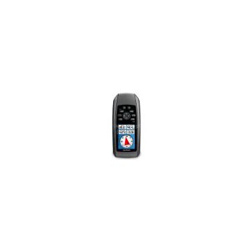
GPSMAP 78s Handheld GPS With Compass and Barometer
- T/T L/C D/P D/A
- 7 days
You May Like
-
 Armin Alpha 100 2 TT10 Dog Collars GPS Dog Tracking Training Combo
-
Zinger Winger Field Trialer G4 w/ Full Electronics
-
Garmin Astro 320 GPS Tracking Collar w/ DC-40 (2 Dog Combo)
-
DE Systems Border Patrol TC1 GPS Invisible Mobile Fence
-
SportDOG TEK 1.0 LT Series GPS Training Collar
-
GoPro Hero3 Silver Edition Action Video Camera
Product Description
Geocaching-friendly handheld GPS with wireless data sharing, compass & altimeter
Garmin has updated the popular GPSMAP 76 with the new GPSMAP 78 Series, powerful marine handheld units that now feature color mapping, a high-sensitivity GPS receiver and a built-in MicroSD card slot for loading additional maps. A whopping 1.7GB of built-in memory provides cutting-edge performance, and you can also add maps from Garmin’s wide array of detailed marine BlueChart g2, topographic and City Navigator road maps. Plus, the 78 Series supports BirdsEye Satellite Imagery, and is compatible with Custom Maps, free software that transforms paper and electronic maps into downloadable maps for your device.
Like earlier generations, these new handhelds feature the same soft-key interface but with a sleek easy-to-hold design with rubber side grips. The “s” models also add a three-axis tilt-compensated electronic compass, which shows your heading even when you're standing still. Each unit features a worldwide basemap, and the 78Cs comes with built-in BlueChart® g2 coastal charts for the U.S. And with the 78 Series, you can share your waypoints, tracks, routes and geocaches wirelessly with other compatible devices. So whether you're kayaking, fishing or just cruising around, the 78 Series has everything a mariner needs. They’re completely submersible and float if dropped overboard.
- Display Type: Transflective 65K color TFT
- Screen Size: 2.6"diag.
- Screen Resolution: 160 x 240
- Cartography: BlueChart® g2 preloaded cards, City Navigator NT®; Supports BirdsEye™ Satellite Imagery (subscription required); Compatible with Custom Maps
- Receiver Type: High-sensitivity
- Battery Type: 2 AA batteries (not included); NiMH or Lithium recommended
- Battery Life: 20 hours
- Dimensions: 2.6"W x 6.0"H x 1.2"D
- Weight: 7.7 oz.
- Waterproof: Rated IPX7 Submersible, and it floats
- Interfacing: High-speed USB and NMEA 0183. Garmin Connect™ compatible (online community where you analyze, categorize and share data). Unit-to-unit transfer (shares data wirelessly with similar units)
- Included Equipment: Wrist strap, USB cable, manual
- Warranty: One year
Contact Us
- Aoli Technology (Hong Kong)Co. Ltd
- Contact nameWang Mike Chat Now
- Phone86-755-36944900
- Address4 building,Seg science park, Huaqiangbei Road, Futian District, Shenzhen, Guangdong, China, Shenzhen, Guangdong, China, Guangdong, China
Product Categories
| New product |
New Products
Popular Searches
- satellite
- gsm
- gps navigator
- gps navigation box
- gps chipset
- car gps
- box gps car navigation
- vehicle device
- gps tracker
- car tracker
- gps car alarm
- tracking car alarm
- gps navigation
- car navigation
- gps navigation system
- car gps tracker
- gps tracking system
- gps vehicle tracking system
- gps map
- mini antenna satellite
- sim card backup
- car gps navigation
- gps system
- navigator
- gps device
- portable gps
- car navigation gps
- tracker gps
- gps tracking
- marine gps
Recommended Products
- GPS for Children and Elderly, 4G Locator for Children and Babies, Anti Turning Remote Tracking for the Elderly, Anti Loss Pendant, Anti Loss Device
- 4G Wireless GPS Locator, Car Anti-theft Pickup Positioning, Remote Tracking Tracker, Car Mounted Beidou Anti Loss Device
- Original SMC IP200-120 Cylinder Positioner New Original Authentic
- Hi Target GPS V200 GNSS RTK Receiver With Tilt Sensor
- Hi Target GPS V200 GNSS RTK Receiver With Tilt Sensor
- 4 Channel HD Mobile DVR 1080P Public Bus Truck Mdvr GPS 3G 4G Mobile DVR
- Full HD HDD 8CH 1080P DVR Para Vigilância Por Vídeo de Segurança de Veículos
- 107M Series (Type A, Type B, Type C, Type D) Double Antenna Combination Micro Inertial Measurement System
- 105M Series (Type A, Type B, Type C, Type D) Single Antenna Combination Micro Inertial Measurement System
- INS1200 Series Fiber Optic GNSS/INS Integrated Inertial Navigation System of Type A, Type B, Type C, and Type D
- INS900 Series Fiber Optic GNSS/INS Integrated Inertial Navigation System of Type A, Type B, Type C, and Type D
- INS600 Series Fiber Optic GNSS/INS Integrated Inertial Navigation System of Type A, Type B, Type C, and Type D
Find Similar Products By Category
- Electrical & Electronics > GPS > GPS Navigator
- Please Enter your Email Address
- Please enter the content for your inquiry.
We will find the most reliable suppliers for you according to your description.
Send Now-
 Wang Mike
Hi there! Welcome to my shop. Let me know if you have any questions.
Wang Mike
Hi there! Welcome to my shop. Let me know if you have any questions.
Your message has exceeded the limit.
- Contact supplier for lowest price
- Customized Request
- Request Sample
- Request Free Catalogs
Your message has exceeded the limit.
-
Purchase Quantity
-
*Sourcing Details
Your inquiry content must be between 10 to 5000 characters.
-
*Email
Please enter Your valid email address.
-
Mobile