

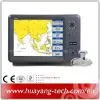
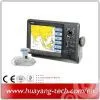
Marine GPS Fish Finder Combo


Related Products
-
 Marine GPS Receiver AntennaNegotiableMOQ: 10 Pieces
 -
Matsutec 4.3inch Marine GPS/SBAS NavigatorNegotiableMOQ: 1 Piece
-
HP-528 4.3" LCD GPS Marine Navigator for ShipUS$ 150 - 170MOQ: 1 Piece
-
12 Inch Marine GPS ChartplotterNegotiableMOQ: 1 Piece
-
5.6 Inch Marine GPS Chartplotter With Echo Sounder ComboNegotiableMOQ: 1 Piece
MODEL: KP-6299C KP-8299C KP-1299C
COLOR LCD GPS PLOTTER SOUNDER
FEATURE:
1) KP-6299C: 5.6 inches Color TFT Display, 640*640 pixels
2) KP-8299C: 8 inches Color TFT Display, 800*600 pixels
3) KP-1299C: 12 inches Color TFT Display, 800*600 pixels
2. 8 Color or 8 Level Amber Presentation
3. 50/200 KHz Transceivers, Output Power:
1) KP-6299C 300 Watt
2) KP-8299C 600 Watt
3) KP-1299C 600 Watt
4. Blue, Light Blue, or Black Background Color
5. 8 Range Scales, from 0-15 to 0-1000 Feet
6. Range Offset to 1000 Feet, Maximum Offset Range of 2000 Feet
7. Automatic Range and Grain Selection Mode
8. A-Scope Display for Rapid Fish ID and Detection
9. Multiple Display Modes:
-Single or Dual Frequency
-Bottom Zoom
-Bottom Lock Expansion
-Maker Zoom
-Navigation Data Screen
-A-Scope
10. Digital Display of Speed, Depth, Water Temp and Position
11. Adjustable Bottom or Fish Alarm
12. Calibration in Feet, Fathoms or Meters
13. Built-in Picture Simulator
14. SD-cards slot for C-Map and user data
15. C-Map MAX and K-Chart Selectable
16. Tide table
17. Versatile Display Mode Include
-Plotter Screen
-Plotter + Sounder
-Sounder
-Nav.Data
-Satellite Information
-AIS Display
-Compass Screen
18. GOTO track navigation
19. MAP orientation select
20. Proximity waypoints alarms
21. Perspective View
22. MAP Palette
-Normal
-Daylight – exposed to sunlight
-Night – in dark environment
-NOAA – paper chart colors
SPECIFICATION
PLOTTER CHARACTERISTICS
1. Waypoints/Icons: 15,000 waypoints with name, symbol, 10 proximity waypoint.
2. Route Memory: waypoint up to 200 points each, plus MOB and Track Navigator or Goto Track modes
3. Tracks: 30,000 points automatic track log; 15 saved track (up to 2000 track points each) Let you retrace your path in both directions
4. Alarm: XTE, Anchor Drag, Arrival, Speed, Voltage, Proximity, Waypoint and Time, AIS alarm.
5. Palette
- Normal
- Daylight: Exposed to sunlight
- Night: In dark environment
- NOAA Paper chart color
6. Tides: Tide Data
7. Projection: Mercator projection
8. Position format: Lat/Lon
9. Base Map: Built-in ONWA K-Chart
10. External Map: SD cards slot for user settings
11. User data storage: Internal backup of user settings, or external SD-card
12. Plot Interval: 1s to 99h or 0.01nm to 9.99nm
13. Polotting scales: 0.01nm to 1,000nm
14. Nav Data Input/Output:
15. PERSPECTIVE VIEW: On/off

Send Inquiry to This Supplier


You May Also Like
-
12 Inch Marine GPS/AIS Chart PlotterNegotiableMOQ: 1 Piece
-
12 Inch Marine GPS Chartplotter KP-1299NegotiableMOQ: 1 Piece
-
AIS SART for Distress BoatNegotiableMOQ: 2 Kilograms
-
Marine AIS GPS Buoy for Fishing NetNegotiableMOQ: 1 Kilogram
-
Marine ClASS B AIS SystemNegotiableMOQ: 1 Kilogram
-
Sonar Fish Finder Fishing EquipmentNegotiableMOQ: 1 Kilogram
-
Marine Fishing Net Locator Beacon AISNegotiableMOQ: 1 Piece
-
Marine GPS CHART PLOTTER With AIS TransponderNegotiableMOQ: 1 Kilogram
-
Marine Dock for Isatphone Pro Portable PhoneNegotiableMOQ: 1 Set
-
Isatdock for Inmarsat Protable PhoneNegotiableMOQ: 1 Piece

