

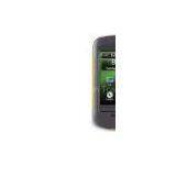
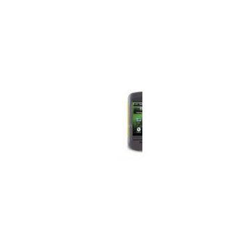
Garmin Montana 600 Touch-Screen Handheld GPS Receiver
Related Products
-
 Garmin Oregon 550t Touch-Screen Handheld GPS ReceiverNegotiableMOQ: 33 Pieces
 -
Garmin Oregon 450t Touch-Screen Handheld GPS ReceiverNegotiableMOQ: 33 Pieces
-
Garmin GPSMAP 78sc Color Hand Held GPS ReceiverNegotiableMOQ: 33 Pieces
-
Garmin GPSMAP 62ST Rugged High Performance Handheld GPS ReceiverNegotiableMOQ: 33 Pieces
-
Magellan EXplorist 710 Hand Held GPS ReceiverNegotiableMOQ: 33 Pieces
Take it hiking. Take it hunting. Take it on the water. The Garmin Montana 600 features a 4" diagonal color touchscreen with dual orientation and a 3-axis tilt-compensated compass and barometric altimeter.. Buy the auto mount (click here) and a City Navigator NT (click here) map, and it'll give you spoken turn-by-turn driving directions in the car or motorcycle. Add a BlueChart g2 (click here) pre-programmed card, and the Montana becomes your chartplotter. It even has has a 5 megapixel camera to boot!
See the Big View
Montana 600 features a vast 4" diagonal, sunlight-readable touchscreen display that offers crystal clear enhanced colors and displays high-resolution images. It's easy-to-use interface means you'll spend more time enjoying the outdoors and less time searching for information. Both durable and waterproof, Montana 600 is built to withstand the elements. Bumps, dust, dirt, humidity and water are no match for this rugged navigator. No matter the setting – on the boat, in the RV or on an ATV – Montana is right at home.
Take Geotagged Pictures
Capture locations and memories with Montana 600's 5 megapixel digital camera. Each photo is geotagged automatically with the location of where it was taken, allowing you to navigate back to that exact spot in the future. Snap and view pictures in landscape or portrait orientation. To keep track of your photos and show their location on a map, simply connect Montana 600 via USB and use Garmin's free BaseCamp software. For more storage, insert a microSD card; you can even view pictures from other devices on microSD with Montana's picture viewer.
Go Anywhere
With an array of compatible mounts, Montana 600 is designed for use on ATV's, in boats, as a handheld or in your car as a personal navigator. Use the auto mount with City Navigator maps for spoken, turn-by-turn driving directions, or the rugged mount for your motorcycle or ATV. Wherever you think you might take Montana, it has the mapping and mounts to get you there.
Go Everywhere
Adding more maps is easy with Garmin's wide array of detailed topographic, marine and road maps. With its microSD card slot, Montana 600 lets you load TOPO U.S. 24K maps and hit the trail, plug in BlueChart g2 (click here) preloaded cards for a great day on the water or City Navigator map data for turn-by-turn routing on roads (see maps tab for compatible maps). Montana 600 also supports BirdsEye Satellite Imagery (subscription required), that lets you download satellite images to your device and integrate them with your maps. In addition, Montana is compatible with Custom Maps, free software that transforms paper and electronic maps into downloadable maps for your device.
Share Wirelessly
With Montana 600 you can share your waypoints, tracks, routes and geocaches wirelessly with other compatible Garmin GPS users. So now your friends also can enjoy your favorite hike or cache – simply press "send" to transfer your information to similar units, and let the games begin.
Keep Your Fix
With its high-sensitivity, WAAS-enabled GPS receiver and HotFix satellite prediction, Montana 600 locates your position quickly and precisely and maintains its GPS location even in heavy cover and deep canyons. The advantage is clear — whether you're in deep woods or just near tall buildings and trees, you can count on Montana 600 to help you find your way when you need it the most.
Navigate with Ease
Montana 600 has a built-in 3-axis tilt-compensated electronic compass, which shows your heading even when you're standing still, without holding it level. Its barometric altimeter tracks changes in pressure to pinpoint your precise altitude, and you even can use it to plot barometric pressure over time, which can help you keep an eye on changing weather conditions.
Double Your Power
Montana 600 features a one-of-a-kind dual battery system. You'll have the option of using the rechargeable lithium-ion pack or traditional AA alkaline batteries – whichever suits your needs better.
Find Fun
Montana 600 supports geocaching GPX files for downloading geocaches and details straight to your unit. Visit to start your geocaching adventure. By going paperless, you're not only helping the environment but also improving efficiency. Montana 600 stores and displays key information, including location, terrain, difficulty, hints and descriptions, which means no more manually entering coordinates and paper print outs! Simply upload the GPX file to your unit and start hunting for caches.

Send Inquiry to This Supplier

You May Also Like
-
Original SMC IP200-120 Cylinder Positioner New Original AuthenticNegotiableMOQ: 1 Piece
-
12 Inches LCD Display Marine GPS AIS ReceiverUS$ 300 - 900MOQ: 1 Set
-
Alarm Monitoring Center Software for Navigation & GPSUS$ 5 - 55MOQ: 1 Piece
-
Gps Digital Tracking Fuel Level SensorUS$ 40 - 70MOQ: 1 Piece
-
RION-BD982 High Positioning Accuracy GPS Navigation,Can Provide Position Information of Carrier (longitude, Latitude, Height)...NegotiableMOQ: 1 Set
-
GPS+GSM (850/900/1800/1900/2100MHz) / 3dBi GSM, 28dBi GPS Gain GSM/GPS AntennaUS$ 3.5 - 4.5MOQ: 10 Pieces
-
Speed Governor 3098693US$ 1 - 90MOQ: 1 Piece
-
Gps Tracker Key Chain Gps TrackerUS$ 1 - 3MOQ: 500 Pieces
-
The Supply of Digital Printing Clothing ProcessingmNegotiableMOQ: 1 Piece
-
Benz C4 2011 STAR Scanner Mercedes Benz Star Diagnostic Tool MB SD Connect Compact4NegotiableMOQ: 1 Piece

