

TITAN SCP
Related Products
-
 4ft Driveaway Antenna SystemUS$ 12,000 - 15,000MOQ: 1 Set
 -
4ft Communication Satellite AntennaNegotiableMOQ: 1 Set
-
4ft Flyaway Satellite Dish Antenna for CommunicationUS$ 19,000 - 21,000MOQ: 1 Set
-
6ft Driveaway Vehicle Mount Satellite Dish Antenna for CommunicationUS$ 24,000 - 28,000MOQ: 1 Set
-
2.4m Driveaway Satellite Dish Antenna for CommunicationUS$ 44,000 - 53,000MOQ: 1 Set
Titan Super Computing Platform
1.Brief introduction
TITAN Super Computing Platform(TITAN SCP)is the network distributed platform for mapping and remote sensing data. Based on international advanced scheduling and workflow technology, the TITAN SCP implements multiple advanced algorithms, including the multi-satellite multi-sensor joint regional network adjustment, automatic extraction of high-resolution DSM and massive images mosaic. Meanwhile, the TITAN SCP implements automated process for aerial triangulation of Aerial and Space Images, orthorectification, image mosaic and standard subdivision products. This platform can provide remote sensing mapping products under the normal and emergency situations and provide professional solutions of remote sensing data processing for mapping, resources survey, military reconnaissance and other fields.
2.Functional performance
(1)Customizable production process
The TITAN SCP has perfect combination of scientific workflow for data-oriented and business workflow for control-oriented, forming a "Production Workflow", which merges between processing of large-scale computing and processing of human interaction seamlessly.
(2)Intelligent scheduling and system resource monitoring
According to the load or custom properties, the system can perform computing tasks on multiple nodes, including distribution, implementation and monitoring. The platform has parallel computing model based on multicore GPU-CPU and has a strong automatic fault tolerance.
(3)Processing monitoring
The platform can provide detailed reports on the entire implement process dynamically.
(4)Satellite Imagery Block Adjustment
In the case of small amount of control points, the platform can implement large scale satellite images block adjustment based on the multi-satellite-multi-camera (including panchromatic, multi-spectral, stereo pair, etc.).
(5)Supporting multiple data sources and multiple outputs
Supporting national and international satellite remote sensing data, unmanned aerial vehicles and other box-spoke data aerial camera data, such as: ZY-3, GF-1, GF-2, TH-1, SPORTS-6, QuickBird, WorIdView, ordinary digital camera, DMC, UCX, etc. multiple outputs include air three outcomes, nuclear-ray image, point cloud data, DOM and DEM.
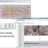
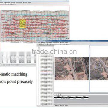
(6)Matching of heterologous Images
The platform can match the connection points of satellite images from different sensors, different solution and different time automatically, under difficulties of feature change, scale, rotation, translation and so on.
(7)auto-extraction of high-precision DEM
Based on intensive matching at the speed of more than 16, 000 points per second, this platform implements extraction of 3D information of fine physiognomy and texture.
(8)Massive remote sensing image mosaic concurrently
The Platform can mosaic large area multi-view image, by using multi-node parallel computing mosaic to improve processing speed.
(9)Dodging uniform color and color mapping
Through color space conversion technology, the "low-resolution color image'' is mapped to the "large area stitching results”, which solves uneven and difficult issues of massive data regional color transition.
(10)Using Web Station conveniently
Online browsing for remote processing of data;
Processing tasks submitted directly to a Web-based interface;
Distributed computing;
Monitoring tasks and computing resources.
Setting priority of perform processing, time and custom constraints;
View schedule and information of parallel processing execution.
(12)Seamless integration and deploy of full-featured API
Providing access to a complete API;
Achieving packaging and invoke the remote computing services;
Extend of computing resources, processing and applications;
Integrating user's own outputs.
(13)Multi-level extension mechanism of system
Scalable parallel algorithms for different areas;
Computing resources dynamically scalable, plug and play;
Processing custom editable;
Integrating with other software.
3.Typical case
Test data:9 Tianhui Satellite panchromatic and multispectral images in Beijing.
Process: full color junction / control point automatic matching, flat area network adjustment, orthorectification, based on the existing DEM / DOM.
Error: 0.8 pixel

Send Inquiry to This Supplier

You May Also Like
-
Car Inspection Line Vehicle Examination Station Car Checking LaneUS$ 10,000 - 30,000MOQ: 1 Unit
-
Online Software Development, Mobile Application DevelopmentNegotiableMOQ: 1 Unit
-
China Agent for Bags Products Factory Souring ,quality Control ,export ,certificate for BagsUS$ 0.3 - 0.5MOQ: 600 Cartons
-
Yiwu Market, Guangzhou Market,Guangzhou Fair, Mixed Container Agent, China Sourcing Agent, China One Stop Export AgentUS$ 0.11 - 100MOQ: 10 Boxes
-
Looking for Professional Furniture Buying Purchasing Delivery Business Agent Foshan Guangzhou Trade Show Traveling ServiceUS$ 50 - 1,000MOQ: 1 Case
-
Inspection ServiceUS$ 200 - 20,000MOQ: 1 Case
-
Custom Clearance in Russia (VOSTOCHNYY)US$ 100 - 100MOQ: 1
-
Temperature Check Indicator/8 Level/Waterproof/Irreversible/Made in JapanUS$ 250 - 500MOQ: 40 Pieces
-
What is CIQ Document Made in ChinaNegotiableMOQ: 1 Piece
-
Inspection Service, Quality Control and Lab Test ConsultationUS$ 180 - 280MOQ: 1 Case

