

Glonass Navigation GPS Navigation for Land Mapping


Related Products
-
 V30 GNSS GPS GLONSS BDS Base or Rover RTK SurveyingUS$ 0.1 - 0.2MOQ: 1 Set
 -
Hi-target V60 GNSS Rtk System With RINEX Data Storage FormatUS$ 0.1 - 0.2MOQ: 1 Sheet
-
Hi-Target GNSS GPS GLONSS BADS RTK Base or Rover Land SurveyingUS$ 0.1 - 0.2MOQ: 1 Set
-
V60 GNSS GPS Glonass Base or Rover RTK Survey InstrumentsUS$ 0.1 - 0.2MOQ: 1 Set
-
HIGH PRECISION GPS RECEIVER GLOBAL POSITION SYSTEMS HI-TRAGET V60 RTKUS$ 0.1 - 0.2MOQ: 1 Set
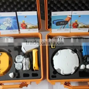
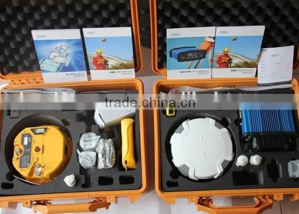
V60 GNSS GPS GLONSS BDS RTK Survey or Static Survey
Features:
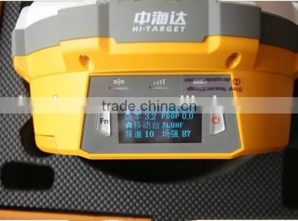
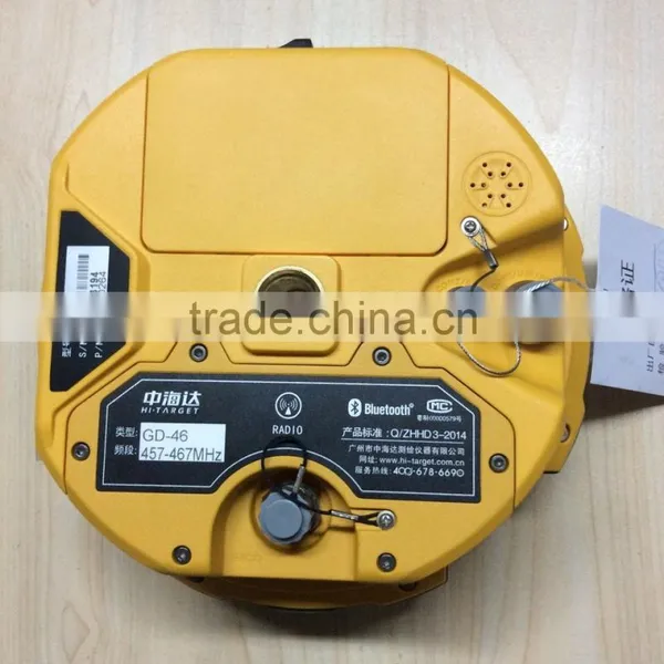
The V60 is a more compact-design and higher-performance GNSS RTK system, besides its rugged design to resist impact and vibration. It has industrial OLED display screen on its front control panel to show all information and status of the work. With the smart speaker inside the receiver, the DIY guiding voice can be customized in any language, even dialect! 1GB internal storage plus 8GB Micro SD card memory is standard, the V60 supports up to 32GB extension of memory. Be fully compatible with other GNSS RTK receivers from the world market. The static data can be saved directly in RINEX format.
Mian Application:
1.Construction Layout
2.Electric power transportation
3.CORS application
4.CORS site
5.Control survey
6.Data collection
7.Water Measurement
8.Construction Positioning (water)
Performance:
|
Satellite signals tracked simultaneously |
GPS: Simultaneous L1C/A, L2C, L2E, L5 |
GLONASS: Simultaneous L1C/A, L1P, L2C/A (GLONASS M only), L2P | |
SBAS: Simultaneous L1 C/A, L5 | |
Galileo: Simultaneous L1 BOC, E5A, E5B, E5AltBOC | |
BDS: B1, B2 | |
QZSS: L1 C/A, L1 SAIF, L2C, L5 |
|
Positioning Accuracy |
Static and Fast Static GNSS surveying |
Horizontal: 2.5mm+0.5ppm RMS
Vertical: 5mm+0.5ppm RMS |
|
Stop & Go GNSS surveying |
Horizontal: 1cm+1ppm RMS Vertical: 2.5cm+1ppm RMS Initialization time: typically 10 minutes for base while 5 minutes for rover Initialization reliability: typically > 99.9% |
||
Realtime Kinematic(RTK) surveying |
Horizontal: 8mm+1ppm RMS Vertical: 15mm+1ppm RMS Initialization time: typically < 8 seconds Initialization reliability: typically > 99.9% |
||
|
Code Differential GNSS positioning |
Horizontal: 25cm+1ppm RMS
Vertical: 50cm+1ppm RMS
SBAS[iv]:0.50mHorizontal,0.85m Vertical |
|

Send Inquiry to This Supplier

You May Also Like
-
Original SMC IP200-120 Cylinder Positioner New Original AuthenticNegotiableMOQ: 1 Piece
-
GPS NavigatorNegotiableMOQ: 2500 Pieces
-
Alarm Monitoring Center Software for Navigation & GPSUS$ 5 - 55MOQ: 1 Piece
-
Analog Capacitive Level Sensor With Stainless Steel ProbeUS$ 40 - 80MOQ: 1 Piece
-
RION-BD982 High Positioning Accuracy GPS Navigation,Can Provide Position Information of Carrier (longitude, Latitude, Height)...NegotiableMOQ: 1 Set
-
GPS+GSM (850/900/1800/1900/2100MHz) / 3dBi GSM, 28dBi GPS Gain GSM/GPS AntennaUS$ 3.5 - 4.5MOQ: 10 Pieces
-
Speed Governor 3098693US$ 1 - 90MOQ: 1 Piece
-
Gps Tracker Key Chain Gps TrackerUS$ 1 - 3MOQ: 500 Pieces
-
Child Aviation Restraint System for Airplane TravelEUR 3 - 7MOQ: 200 Pieces
-
Globalsat BU-353 BU353 Android Tablet USB GPS Receiver Linux SIRF III Navigation Micro USB GPS Receiver BlackUS$ 1 - 100MOQ: 100 Pieces

