

Hi-Target GNSS GPS GLONSS BADS RTK Base or Rover Land Surveying


Related Products
-
 V60 GNSS GPS Glonass Base or Rover RTK Survey InstrumentsUS$ 0.1 - 0.2MOQ: 1 Set
 -
HIGH PRECISION GPS RECEIVER GLOBAL POSITION SYSTEMS HI-TRAGET V60 RTKUS$ 0.1 - 0.2MOQ: 1 Set
-
Land Surveying Mapping With GPS Receiver Hi Target RTK GNSS GPS SystemUS$ 0.1 - 0.2MOQ: 1 Set
-
Geo Information Collector RTK GPS Surveying Instrument With Hi Target V60 GNSS RTK for Land Surveying MappingUS$ 0.1 - 0.2MOQ: 1 Set
-
Civil Engineering Equipment With Hi Target GNSS RTK Surveying Instrument V30 GPS RTK InstrumentUS$ 0.10 - 0.10MOQ: 1 Set
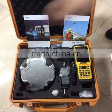
V60 GNSS RTK SYSTEM
The V60 is a more compact-design and higher-performance GNSS RTK system, besides its rugged design to resist impact and vibration. It has industrial OLED display screen on its front control panel to show all information and status of the work. With the smart speaker inside the receiver, the DIY guiding voice can be customized in any language, even dialect! 1GB internal storage plus 8GB Micro SD card memory is standard, the V60 supports up to 32GB extension of memory. Be fully compatible with other GNSS RTK receivers from the world market. The static data can be saved directly in RINEX format.
System Features:
Linux Operation System
ARM 9G20 400MHz CPU, embedded Linux OS to support faster data transmission.
Intelligent Operation
Equipped with smart speaker guiding during the whole operation. Voice assistance can help you master V60 operation quickly. Language can be customized.
Industrial LED display screen on its front control panel to show all information and status of the work.
Many one-button operations make your work easily. Base setup by one button can choose base coordinate from base list automatically.
Automatic recording system log makes receiver diagnosis easy.
RINEX Storage
The static data can be saved directly in RINEX format. The V60 is fully compatible with other brands’ receivers.
Quick Upgrade
Just copy the updated firmware to the V60, then restart to finish the upgrade in a few seconds.
Multi Constellation Tracking
220 tracking channels.
Supports GPS, GLONASS, GALILEO, BDS, SBAS.
Built-in NGS Approved Antenna.
High Power Transceiver UHF Radio
The transceiver UHF radio enables the working mode switchable between base and rover.
5 watts (Max.) HI-TARGET internal UHF radio and 2 watts (Max.)Pacific Crest micro XDL internal UHF radio are optional
Pacific Crest TrimTalk© internal UHF radio is compatible with other RTK.
Seamlessly Operation in CORS System
Built-in GPRS/GSM/3G module makes V60 work perfectly with network RTK positioning.
Long-life Battery
Powered by 5000mAh Li-Ion battery.
Static working time 13 - 15 hours
RTK Rover(UHF/GPRS/3G) working time 10 - 12 hours
RTK Base working time 8 - 10 hours
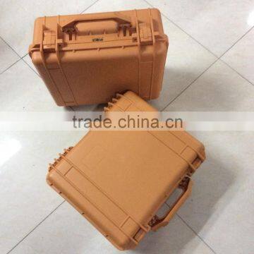
Rugged Design, IP67
IP67 dust/water protection.
Withstands 3 meters natural fall onto concrete.
Rapidly track and perfectly avoid or lessen obstruction and multipath effect to ensure superior positioning capability.
Technical parameters:
MEASUREMENTS
• 220 Channels
• Advanced Pacific Crest Maxwell 6 Custom Survey GNSS Technology
• High precision multiple correlator for GNSS pseudo range measurements
• Unfiltered, unsmoothed pseudo range measurements data for low noise, low multipath error, low time domain correlation and high dynamic response
• Very low noise GNSS carrier phase measurements with <1 mm precision in a 1 Hz bandwidth
• Signal-to-Noise ratios reported in dB-Hz
• Proven Pacific Crest low elevation tracking technology
Satellite signals tracked simultaneously
GPS: Simultaneous L1C/A, L2C, L2E, L5
GLONASS: Simultaneous L1C/A, L1P, L2C/A (GLONASS M only), L2P
SBAS: Simultaneous L1 C/A, L5
Galileo: Simultaneous L1 BOC, E5A, E5B, E5AltBOC
BDS/Compass: B1, B2
QZSS: L1 C/A, L1 SAIF, L2C, L5
POSITIONING PERFORMANCE
Static and Fast Static GNSS surveying
Horizontal: 2.5mm+0.5ppm RMS
Vertical: 5mm+0.5ppm RMS
(PPK / Stop & Go) GNSS surveying
Horizontal: 1cm+1ppm RMS
Vertical: 2.5cm+1ppm RMS
Initialization time: typically 10 minutes for base while 5 minutes for rover
Initialization reliability: typically > 99.9%
RTK surveying
Horizontal: 8mm+1ppm RMS
Vertical: 15mm+1ppm RMS
Initialization time: typically < 8 seconds
Initialization reliability: typically > 99.9%
Code Differential GNSS positioning
Horizontal: 25cm+1ppm RMS
Vertical: 50cm+1ppm RMS
SBAS: 0.50m Horizontal, 0.85m Vertical
HARDWARE
Physical
Dimensions (W x H): 18.20cm x 9.80cm (7.17 in x 3.86 in)
Weight: 1.25kg (2.76lb) without internal battery
Operating temperature: -45℃ to +65℃ (-49℉ to +149℉)
Storage temperature: -55℃ to +85℃ (-67℉ to +185℉)
Humidity: 100%, considering
Water/dustproof: IP67 dustproof, protected from temporary immersion to depth of 1m (3.28ft).
Shock and Vibration: Designed to survive a 3m (9.84ft) natural fall onto concrete.
Electrical
Power 6V to 28V DC external power input
Power consumption ≤3.5W
Automatic Switching between internal power and external power
Rechargeable, removable 7.4V, 5000mAh Lithium-Ion battery in internal battery compartment
Internal battery life
Static 13 - 15 hours
RTK Rover (UHF/GPRS/3G) 10 - 12 hours
RTK Base 8 - 10 hours
I/O interface
1 x Bluetooth
1 x standard USB2.0 port
1 x TNC UHF connector
2 x RS232 serial port
2 x DC power input (8-pin & 5-pin)
1 x Micro SD card port
COMMUNICATION AND DATA STORAGE
3G Communication
Fully integrated, fully sealed internal 3G, compatible with GPRS
Network RTK (via CORS) range 20-50km
HI-TARGET internal UHF radio (standard)
Frequency: 450~470MHz with 116 channels
Transmitting Power: 1W, 2W, 5W adjustable
Transmitting Speed: 9.6Kbps, 19.2Kbps
Working Range: 5km typical, 8~10km optimal
Pacific Crest internal UHF radio(Optional)
Frequency: 403~473 MHz
Transmitting Power: 0.5W, 2W adjustable
Transmitting Speed: Up to 19.2Kbps
Support most of radio communication protocol
Working Range: 3~5km typical, 8~10km optimal
HI-TARGET External UHF radio (standard)
Frequency: 460 MHz with 116 channels
Transmitting Power: 5W, 10W, 20W, 30W adjustable
Transmitting Speed: Up to 19.2Kbps
Working Range: 8~10km typical, 15~20km optimal
Pacific Crest ADL Vantage Pro External UHF radio(Optional)
Frequency: 390~430 MHz or 430~470 MHz
Transmitting Power: 4W to 35W adjustable
Transmitting Speed: Up to 19.2Kbps
Support most of radio communication protocol
Working Range: 8~10km typical, 15~20km optimal
Support other external communication device
For example, external GSM modem.
Data storage
1GB Internal storage+ 8GB Internal Micro SD Card memory (Support up to 32GB extension)
Record GNS and Rinex format simultaneously
Data formats
(1Hz positioning output, up to 50 Hz - depends on installed option)
CMR: sCMRx, CMR, CMR+ input and output
RTCM: RTCM 2.1, 2.2, 2.3, 3.0, 3.1, 3.2 input and output
Navigation outputs ASCII: NMEA-0183 GSV, AVR, RMC, HDT, VGK, VHD, ROT, GGK, GGA, GSA, ZDA, VTG, GST, PJT, PJK, BPQ, GLL, GRS, GBS
Navigation outputs Binary: GSOF
1 Pulse Per Second Output

Send Inquiry to This Supplier

You May Also Like
-
Original SMC IP200-120 Cylinder Positioner New Original AuthenticNegotiableMOQ: 1 Piece
-
GPS NavigatorNegotiableMOQ: 2500 Pieces
-
Alarm Monitoring Center Software for Navigation & GPSUS$ 5 - 55MOQ: 1 Piece
-
Analog Capacitive Level Sensor With Stainless Steel ProbeUS$ 40 - 80MOQ: 1 Piece
-
RION-BD982 High Positioning Accuracy GPS Navigation,Can Provide Position Information of Carrier (longitude, Latitude, Height)...NegotiableMOQ: 1 Set
-
GPS+GSM (850/900/1800/1900/2100MHz) / 3dBi GSM, 28dBi GPS Gain GSM/GPS AntennaUS$ 3.5 - 4.5MOQ: 10 Pieces
-
Speed Governor 3098693US$ 1 - 90MOQ: 1 Piece
-
Gps Tracker Key Chain Gps TrackerUS$ 1 - 3MOQ: 500 Pieces
-
Child Aviation Restraint System for Airplane TravelEUR 3 - 7MOQ: 200 Pieces
-
Globalsat BU-353 BU353 Android Tablet USB GPS Receiver Linux SIRF III Navigation Micro USB GPS Receiver BlackUS$ 1 - 100MOQ: 100 Pieces

