

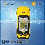
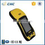
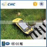
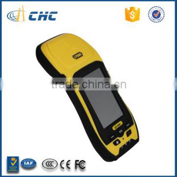
CHC LT500N GNSS GIS Handheld Receiver, Data Collector


Related Products
-
 CHC LT30TM Gps Handheld, Handheld GPS SurveyUS$ 1,400 - 1,700MOQ: 1 Piece
 -
CHC LT30 Magellan Gps Handheld Affordable GIS Instrument Magellan Gps MapsUS$ 1,100 - 1,300MOQ: 1 Piece
-
CHC LT30TM Gps Handheld Gps Gps Rtk Rtk Gps ReceiverUS$ 1,400 - 1,700MOQ: 1 Piece
-
CHC LT500H GNSS GIS Handheld Receiver, Data Collector, GPS MappingUS$ 6,500 - 8,000MOQ: 1 Unit
-
CHC LT30 GPS Handheld GPS, Handheld GPS Survey,RTK GPS GNSS Quality ChoiceUS$ 1,100 - 1,300MOQ: 1 Piece
CHC LT500N >> GNSS Handheld Receiver / Data Collector
Professional Surveying & Mapping Solutions
handheld gps
The LT500 is a rugged, versatile GNSS GIS handheld receiver, that LT500N/LT500T/LT500H covers three accuracy ranges from submeter to centimeter accuracy and is the most cost effective positioning solution for Survey, Construction and GIS professionals.
data collector
LT500N GNSS Kit
| LT500N GPS (Sub Meter Level) | 12 Channel L1 GPS | ||
| Part Number | Description | Pcs |
| LT500N Kit | ||
| 0505 120 009 | LT500N Kit | 1 |
| 1250 811 223 | LT500N GPS Receiver | 1 |
| 0406 000 041 | Carry Pouch | 1 |
| 0403 000 083 | Data Cable | 1 |
| 0405 000 063 | Li-ion battery | 1 |
| 0405 000 099 | Power Adapter | 1 |
| 0103 020 183 | Stylus | 1 |
| Software | ||
| 0408 000 024 | DigiTerra Advanced Software | 1 |
| 0408 000 021 | DigiTerra Professional Software | 1 |
| Additional Accessory | ||
| 0405 000 099 | LT500 Power Adapter | 1 |
| 0403 000 083 | LT500 Data Cable | 1 |
| 0406 000 041 | LT500 Carry Pouch | 1 |
| 0101 080 005 | 8G TF Card | 1 |
| 0103 020 183 | LT500 Stylus | 1 |
| 0405 000 063 | LT500 Lithium Battery | 1 |
data collector
LT500H L1/L2 GPS+GLONASS, L1 BDS, L1 Galileo Tracking
The LT500H addresses a centimeter level position accuracy utilizing the internal cellular modem to access a local reference station network under RTK working mode.
LT500T L1 GPS+GLONASS+BDS+Galileo
The LT500T is designed to work in the projects requiring the decimeter accuracy, in the application as utilities, underground pipelines and land records management when high accuracy is required.ndheld gps survey
LT500N L1 GPS
Embedded with professional GPS engine, the LT500N prepares the user to capture submeter data with SBAS differential correction signals or DGPS correction information from the local reference station.
Productive sensors
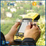
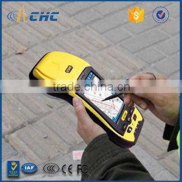
User productivity is greatly enhanced with the builtin gyroscope, an innovative laser plummet for positioning the accurate handheld receiver over a point, an Ecompass for showing the direction and a Gsensors for leveling. Optional RFID and 1D/2D bar code scanners help automate complex inventory tasks.
Stay connected
Builtin standard 3.5G cellular modem and WiFi keep you connected to RTK corrections' networks and provide seamless internet access. Bluetooth is available for connection with other hardware such as laser range finder, underground pipeline locator.
data collector
Key Features
LT500N data collectorsurvey trimble tsc2
data collector
GNSS Characteristic |
| Type | LT500H | LT500T | LT500N |
| Channel | 120 | 220 | 12 |
| Satellite Signals | GPS: L1, L2. GLONASS: L1, |
GPS: L1 GLONASS: L1. |
GPS: L1 |
| Update Rate | 1 Hz, or higher | 1 Hz, or higher | 1 Hz, or higher |
| Protocols | RTCM2.x/RTCM3.x |
RTCM2.x/RTCM3.x |
RTCM2.x |
| Cold Start | < 50s | < 45s | < 60s |
| Hot Start | < 35s | < 30s | < 30s |
| Reacquisition | < 1s | < 2s | < 1s |
| Stand alone GPS | 1.2m | 2m | 2.5m |
| Realtime Correction | 1cm | 25cm | 60cm |
| With SBAS | Horizontal: 50cm | Horizontal: 50cm | Horizontal: 1m |
| Real-time Correction | Horizontal: 1cm |
Horizontal : 25cm |
Horizontal : 60cm |
| Post Processing Static | Horizontal: 5 mm ± 1 ppm |
Horizontal: 5 mm ± 1 ppm |
Horizontal: 5 mm ± 1 ppm |
trimble tsc2
More Details: data collector
| System configuration | · Windows® Embedded Handheld 6.5 operation system
|
Physical | · Size (LxWxH): 236 x 97 x 77 mm (9.3 x 3.8 x 3.0 in)
· Weight: 897 g with battery (31.6 oz)
|
| Display | · 4.3” sunlight readable screen
|
Electrical | · Li-ion battery capacity: 11.1V, 2600 mAh
|
| Communications | · Cellular Modem
|
Sensors | · Gyroscope
· Gsensor
|
handheld gps
datacollector
CHC provides the most reliable packaging to perfectly protect the equipment from transportation damages.
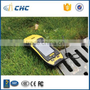
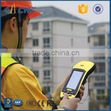
Rugged design helps you to work in kind of hursh environment.
No matter it is traditional survey work or GIS work, the built in high performance GNSS models makes your work more efficeint and easy. data collector
CHC has the latest production facilities, professional production lines and strict testing requirement to make sure every device on your hands is with good quality and can be trusted.data collector
CHC will always dedicate the best service to you.trimble tsc2
|
Shanghai Huace Navigation Technology LTD.
599 Gaojing Road, Building C,
Reliable - Powerful - Competitive |
|
trimble tsc2

Send Inquiry to This Supplier

You May Also Like
-
Endress+Hauser E+H Compact Conductivity Device Smartec CLD18-BGGENegotiableMOQ: 1 Piece
-
Flexible Cellular Polymeric Tensile Tester for Medical and Industrial Foam ApplicationsUS$ 3000 - 20000MOQ: 1 Set
-
Hydraulic Plastic Flange Connections Cover Plugs SHF SeriesUS$ 0.22 - 0.28MOQ: 2500 Pieces
-
HST Spring Dyno Friction Leakage Fatigue Testing MachineUS$ 5000 - 10000MOQ: 1 Set
-
Gates 550C 550U U550 U-550 U508 U-508 Japan Unitta U-550 Belt Tension Meter New U-508 Belt Tension Meter Upgraded Version U550US$ 1 - 900MOQ: 1 Piece
-
Analytical Balanace.scale ,weichengya Laboratory SupplierUS$ 10 - 35MOQ: 10 Sets
-
Smart MD-3051 Online Density Meter With 4-20mA OutputUS$ 2,380 - 2,500MOQ: 1 Unit
-
5W-300W Sun Simulator Watt Testing 30% Off / Xenon Lamp Sun Simulator Free Sent / Sun Simulator TestingUS$ 7,500 - 10,000MOQ: 1 Set
-
New Design Measuring Meter With Best PerforanceUS$ 1,000 - 1,200MOQ: 1 Piece
-
XK-1 Rotary Switch Life TesterNegotiableMOQ: 1 Set


