

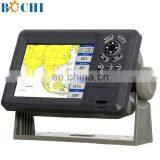
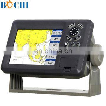
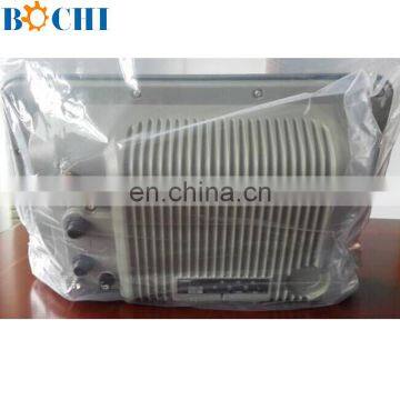
Ship GPS Marine Navigation System


Related Products
-
 12 Inch Marine GPS NavigatorUS$ 200 - 900MOQ: 1 Set
 -
8 Inches Boat Sea GPS NavigationUS$ 300 - 900MOQ: 1 Piece
-
10.4Inches Marine Multi-functional Gps Tracking for BoatUS$ 700 - 900MOQ: 1 Piece
-
8 Inch Marine GPS Antenna For ShipUS$ 300 - 900MOQ: 1 Piece
-
8 Inches Marine Ship GPS Tracking Module Support SD Card/CE CertificateUS$ 200 - 900MOQ: 1 Set
Ship GPS Marine Navigation System
Festures:
C-Map MAX and K-Chart Selectable
Tide table
Versatile display mode include
Plotter Screen
Nav.Data
Satellite Information
AIS Display
Compass Screen
GOTO track navigation
Map orientation select
Proximity waypoints alarms
Perspective View
Spec:
PLOTTER CHARACTERISTICS | |
Waypoints/icons |
15,000 waypoints with name, symbol, 10 proximity waypoint |
Routes |
waypoint up to 200 points each, plus MOB and Track Navigation or Go to Track modes |
Tracks |
30,000 point automatic track log; 15 saved track (up to 2000 track points each) let you retrace your path in both directions |
Alarms |
XTE, Anchor drag, arrival, speed, voltage, proximity waypoint and time, AIS alarm. |
Pallete |
Normal Daylight exposed to sunlight Night in dark environment NOAA paper chart colors |
Tides |
Tide data |
Projection |
Mercator projection |
Position format |
Lat/Lon |
Basemap |
Built-in K-Chart |
External Map |
SD Cards slot for C-Map MAX |
User data storage |
Internal backup of user settings, or external SD-card |
Plot Interval |
1s to 99h or 0.01 nm to 9.99nm |
Plotting scales |
0.01nm to 1,000nm |
Nav Data |
Inputs: |
Perspective View |
On/off |
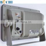
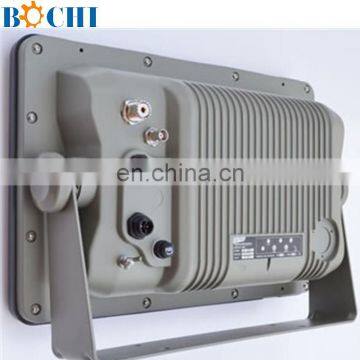
POWER SUPPLY |
10.5 to 35VDC, current drain <300mA at 12V |
PHYSICAL | |
Size |
228mm(H)X138mm(W)X79mm(D) |
Weight |
0.9kg |
Display |
5.6-inches ColorTFT day-view LCD 640 X 480 pixels |
Waterproofing |
Display unit: IPX5 |
Temperature range |
Display unit: -15℃ to +55℃ |
GPS RECEIVER CHARACTERISTICS | |
Receiver |
12 parallel channel GPS receiver continuously Tracks and uses up to 12 satellites to compute and update your position |
Acquisition times |
Cold start: 60 seconds average |
Update rate |
1/second,continuous |
Accuracy |
Position: <15 meters(95%) without S/A |
Dynamics |
Altitude: 18,000m Max |
Datum |
WGS 84 & Others |
Interfaces |
NMEA 0183 input and output,RS232 and RS422 output |
Antenna |
KA07 |
AIS INTERFACE | |
Data input |
NMEA 0183 , R8232 |
Baud rate |
38400 and 4800 |
EQUIPMENT LIST | |
|
Display unit Antenna unit with 10m cable Operation manual Installation materials and standard spare parts | |

Send Inquiry to This Supplier

You May Also Like
-
Engine PartsNegotiableMOQ: 2000 Pieces
-
For Caterpillar C6.6/C7.1 Diesel Generator Set 270-0106 2700106 Fan BladesUS$ 100MOQ: 1 Piece
-
Advance 300 Marine Engine Gear Box Reduction Ratio 4:1NegotiableMOQ: 1 Box
-
Cab Fixed Rectangular Window for Marine SuppliesCAD 200 - 200MOQ: 1 Piece
-
Gorgeous Marine Steel Hatch Cover Supplier With Rich ExperienceUS$ 5 - 20.9MOQ: 500 Pieces
-
Rotomolding Pontoon FactoryUS$ 1 - 100MOQ: 500 Kilograms
-
1/4" Rope Lock Tie Down Boat RopeUS$ 0.5 - 2MOQ: 100 Pieces
-
Eva Foam Boat HullUS$ 100 - 100MOQ: 50 Pieces
-
15ppm Marine Oil Bilge SeparatorUS$ 2,000 - 40,000MOQ: 1 Unit
-
Yacht Dock Marine Pneumatic Boat Rubber Fender F4211- 16.8*4.4inchUS$ 7 - 11MOQ: 50 Sets

