

Related Products
-
 Garmin Oregon 550t - Hiking GPS Receiver - TFT - 240 x 400 - ColorUS$ 90 - 90MOQ: 10 Pieces
 -
Teletype WorldNav 3100 Premium Portable GPS NavigatorUS$ 90 - 90MOQ: 10 Pieces
-
Garmin Astro 220 Dog Tracking System - Hiking GPS Receiver - TFT - 160 x 240 - ColorUS$ 90 - 90MOQ: 10 Pieces
-
Drift HD170 Stealth Action Camera With Extra Battery & 8GB SD CardUS$ 90 - 90MOQ: 10 Sets
-
Pioneer AVIC-Z120BT 7" In-Dash Double-Din Navigation CDUS$ 350 - 350MOQ: 5 Sets
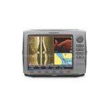
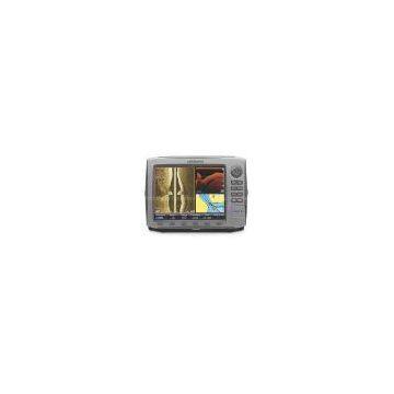
Presenting crystal-clear definition and multi-function performance at its full-color BEST!See all the action in second-to-none clarity on a BIG, high-resolution SolarMAX™ Plus color display in your choice of 10.4" (HDS-10) or 8.4" (HDS-8). Of course, a sonar-enhancing broadband sounder and 16-channel GPS are built in to help you on your way.
Each comes pre-loaded with amazing, NEW map bundles for combined inland and coastal coverage. They're compatible with Navionics® chartcards, too, so you can add maps of your own at any time. Each comes available as a stand-alone unit... great if you already have a compatible Lowrance® transducer, or would like to add another interface to your existing setup... or with your choice of 50/200 kHz transducer (for deep water / offshore use) or 83/200 kHz transducer (for water 900' or less). Read on for more about what the HDS Series has to offer.
Brilliant display:
- Big 600 x 800 16-bit color SolarMAX Plus bright sunlight / wide-angle display for surprisingly crisp, clear views all hours of the day
- Backlit screen and keypad for easy use in bright sunlight or dark conditions
- Split-screen presentation capable
- Provides GPS and sonar overlay data.
Sonar:
- Choice of dual frequency Skimmer®: 50/200 kHz or 83/200 kHz
- HyperScroll™ feature locates and displays fish targets at higher boat speeds with increased soundings per second
- FasTrack™ feature displays flasher-style sonar returns in a narrow vertical column. Especially useful for ice fishing or fishing at anchor
- FlashGraf™ feature combines a scrolling sonar target graph with a digital LCD flasher... two of the most popular ways of finding fish all in one screen.
GPS / Navigation:
- Internal, high-sensitivity 16-channel GPS+WAAS antenna
- Pre-loaded Insight USA™ map bundle delivers unprecedented inland mapping and coastal charting detail with lightning-fast screen display updates (HDS-8 is available with US BaseMaps, featuring 100,000 bodies of water and almost 5,000 enhanced US lakes)
- Stores up to 5,000 waypoints, 200 routes and up to 10 trails
- Navionics chartcard compatible (not included).
More:
- Sealed and waterproof, ready for saltwater use
- Built-in backup memory
- Max 250W peak-to-peak (32W RMS) actual; 30,000W peak-to-peak analog equivalent
- Uses 10-17V DC power source.
Choose yours and order ONLINE today!
LOWRANCE® HDS-10 FISHFINDERS / GPS CHARTPLOTTERS

Send Inquiry to This Supplier


You May Also Like
-
Original SMC IP200-120 Cylinder Positioner New Original AuthenticNegotiableMOQ: 1 Piece
-
12 Inches LCD Display Marine GPS AIS ReceiverUS$ 300 - 900MOQ: 1 Set
-
Alarm Monitoring Center Software for Navigation & GPSUS$ 5 - 55MOQ: 1 Piece
-
Gps Digital Tracking Fuel Level SensorUS$ 40 - 70MOQ: 1 Piece
-
RION-BD982 High Positioning Accuracy GPS Navigation,Can Provide Position Information of Carrier (longitude, Latitude, Height)...NegotiableMOQ: 1 Set
-
GPS+GSM (850/900/1800/1900/2100MHz) / 3dBi GSM, 28dBi GPS Gain GSM/GPS AntennaUS$ 3.5 - 4.5MOQ: 10 Pieces
-
Speed Governor 3098693US$ 1 - 90MOQ: 1 Piece
-
Gps Tracker Key Chain Gps TrackerUS$ 1 - 3MOQ: 500 Pieces
-
The Supply of Digital Printing Clothing ProcessingmNegotiableMOQ: 1 Piece
-
Benz C4 2011 STAR Scanner Mercedes Benz Star Diagnostic Tool MB SD Connect Compact4NegotiableMOQ: 1 Piece

