

Home > Electrical & Electronics > GPS > GPS Navigator > Garmin GPSMAP 546s Color GPS/Sonar Combo With Pre-Loaded Coastal Maps and Saltwater Transducer
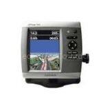
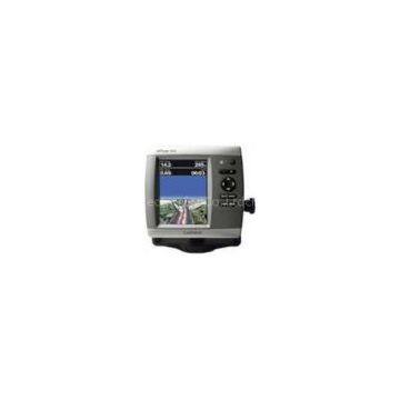
Garmin GPSMAP 546s Color GPS/Sonar Combo With Pre-Loaded Coastal Maps and Saltwater Transducer
Negotiable
MOQ: 50 Pieces (Price negotiable depending on order volume and customization)
Key Specifications
Get Latest Price
Brand Name:
Garmin
Place of Origin:
China
Model Number:
Garmin GPSMAP 546s Color GPS/Sonar Combo with Pre-Loaded Coastal Maps and Saltwater Transducer
Payment & Shipping
Payment Methods:
Port of Shipment:
China
Delivery Detail:
7 days
Related Products
-
 Garmin GPSMAP 526s Color GPS/Sonar Combo With Saltwater TransducerNegotiableMOQ: 50 Pieces
 -
Garmin GPSMAP 541s Color GPS/Sonar Combo With Pre-Loaded Coastal Maps and Saltwater TransducerNegotiableMOQ: 50 Pieces
-
Garmin Fishfinder 400C Compact Sonar SystemNegotiableMOQ: 50 Pieces
-
TomTom GO 2535TM World Traveler Edition Large-Screen Bluetooth GPS System w/ Transatlantic Maps, Lifetime Traffic & Maps BundleNegotiableMOQ: 50 Pieces
-
Garmin GPSMAP 4208 Pre-Loaded BlueChart Network BundleNegotiableMOQ: 50 Pieces
Brand Name
Garmin
Place of Origin
China
Model Number
Garmin GPSMAP 546s Color GPS/Sonar Combo with Pre-Loaded Coastal Maps and Saltwater Transducer
Even in bright sun, it is easy to see the clarity of the GPSMAP 546. These brilliant 5" VGA displays give you a sharp, clear picture, and the fast processor makes for smooth panning and screen redraws as you scroll. Plus, these waterproof units have a high-sensitivity internal GPS receiver, so mariners will alays know their position at sea. They are ready to go with built-in BlueChart g2 marine cartography of the coastal United States - including Alaska, Hawaii, and Explorer Chart data of the Bahamas. Mariners can navigate the waters with ease knowing that these new units include Garmin's proven easy-to-use interface design.
Features and Specifications:
- Bright, crisp 5" diagonal VGA display, 480 x 640 pixels - over 800 nits of brightness
- NMEA 2000 certified for seamless integration with the Garmin marine lineup
- Preloaded with charts for over 14,000 U.S. lakes and navigable rivers
- Compatible with GXM 51 for XM Satellite Radio and XM WX Satellite Weather
- Built-in high-sensitivity GPS receiver
- High-speed processor for fast screen redraws and smooth panning
- Streamlined user interface makes it simple to select modes and features
- Single SD memory card slot for BlueChart g2 Vision cards, as well as saving waypoints, routes and tracks to an SD card
- Optional BlueChart g2 Vision cards provide marine chart detail and enhanced navigation features like Auto Guidance, satellite imagery, 3-D Marin

Send Inquiry to This Supplier

* Email
Want the best price?
Post an RFQ now!
Business Type
Trading Company
Total Employees
101 - 200 People
Main Markets
North America, South America, Eastern Europe
Location
Laiwu, Shandong, China
You May Also Like
-
Original SMC IP200-120 Cylinder Positioner New Original AuthenticNegotiableMOQ: 1 Piece
-
GPS NavigatorNegotiableMOQ: 2500 Pieces
-
Alarm Monitoring Center Software for Navigation & GPSUS$ 5 - 55MOQ: 1 Piece
-
Analog Capacitive Level Sensor With Stainless Steel ProbeUS$ 40 - 80MOQ: 1 Piece
-
RION-BD982 High Positioning Accuracy GPS Navigation,Can Provide Position Information of Carrier (longitude, Latitude, Height)...NegotiableMOQ: 1 Set
-
GPS+GSM (850/900/1800/1900/2100MHz) / 3dBi GSM, 28dBi GPS Gain GSM/GPS AntennaUS$ 3.5 - 4.5MOQ: 10 Pieces
-
Speed Governor 3098693US$ 1 - 90MOQ: 1 Piece
-
Gps Tracker Key Chain Gps TrackerUS$ 1 - 3MOQ: 500 Pieces
-
Child Aviation Restraint System for Airplane TravelEUR 3 - 7MOQ: 200 Pieces
-
Globalsat BU-353 BU353 Android Tablet USB GPS Receiver Linux SIRF III Navigation Micro USB GPS Receiver BlackUS$ 1 - 100MOQ: 100 Pieces

