

Home > Electrical & Electronics > GPS > GPS Navigator > Garmin Rino 655t Handheld GPS and Camera With Altimeter and Preloaded TOPO 100K Maps
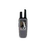
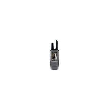
Garmin Rino 655t Handheld GPS and Camera With Altimeter and Preloaded TOPO 100K Maps
Negotiable
MOQ: 1 Piece (Price negotiable depending on order volume and customization)
Key Specifications
Get Latest Price
Brand Name:
Garmin
Place of Origin:
China
Model Number:
Garmin Rino 655t Handheld GPS and Camera with Altimeter and Preloaded TOPO 100K Maps
Payment & Shipping
Payment Methods:
Port of Shipment:
China
Delivery Detail:
7 days
Related Products
-
 Furuno Fcv620 Package W/Tm Tri-DucerNegotiableMOQ: 1 Piece
 -
Si-Tex Cvs 128 8.4\" Digital Color FishfinderNegotiableMOQ: 1 Piece
-
Furuno Fcv 295 10.4\" Fish FinderNegotiableMOQ: 1 Piece
-
Furuno Fcv-585 Color FishfinderNegotiableMOQ: 33 Pieces
-
Humminbird Fishfinder 596c Hd Di Down Imaging FishfinderNegotiableMOQ: 33 Pieces
Brand Name
Garmin
Place of Origin
China
Model Number
Garmin Rino 655t Handheld GPS and Camera with Altimeter and Preloaded TOPO 100K Maps
Flash Memory Capacity: 4.50 GB
Maximum Battery Run Time: 14 Hour
USB: Yes
Memory Card Supported: microSD Card
Height: 7.5"
Width: 2.4"
Depth: 1.8"
Camera Resolution: 5 Megapixel
Color Supported: 65536 Colors (16-bit)
Digital Zoom: 4x
Area Calculation
Hunt/Fish Calendar
Vibration Alert
High-sensitivity Receiver
Screen Size: 2.6"
Altimeter
Compass
Photo Viewer
FRS/GMRS Radio
Battery Rechargeable: Yes
Waypoints: 2000
Display Form Factor: Fixed
Durability: Water Proof
Battery Chemistry: Lithium Ion (Li-Ion)
Display Resolution: 160 x 240
With a 5 W FRS/GMRS radio, 2.6" glove-friendly color touchscreen GPS with preloaded TOPO 100K maps, barometric altimeter, 3-axis electronic compass, NOAA weather radio and 5-megapixel camera, Rino 655t is a jack-of-all-trades.
With its high-sensitivity GPS receiver and quad helix antenna, Rino 655t quickly finds your position and maintains it – even in heavy cover. Plus, a built-in barometric altimeter and 3-axis compass make it easy to get your bearings without the need to hold it level.
The device comes preloaded with TOPO 100K maps, which includes coverage of the full U.S. Adding more maps is easy with Garmin's wide array of detailed topographic, marine and road maps. With its microSD card slot, Rino 655t lets you load TOPO U.S. 24K maps and hit the trail or plug in BlueChart g2 preloaded cards for a great day on the water. The device also supports BirdsEye Satellite Imagery (subscription required), that lets you download satellite images to your device and integrate them with your maps. In addition, Rino 655t is compatible with Custom Maps, free software that transforms paper and electronic maps into downloadable maps for your device.
Rino 655t’s unique Position Reporting capability lets you send your exact location to other Rino users so they can see it on their map page. Plus, improved audio performance means it’s easy to communicate with any other conventional FRS/GMRS radio in the area. It can be useful in an emergency, or just a handy way to keep tabs on your hunting party, hiking partner, family or friends.
With plenty of transmit power, Rino 655t also lets you send unit-to-unit text messages to other Rino users in your area – it's ideal for loud or windy conditions, or just when you don't want to disturb the wildlife. It also lets you share your waypoints, tracks, routes and geocaches wirelessly with other compatible Garmin handheld devices.
With Rino 655t’s built-in 5-megapixel autofocus camera, you'll be able to capture the highlights of your outings. Each photo is automatically geotagged with the location of where it was taken, allowing you – or those you share your photos with – to easily navigate back to that spot in the future.
For added safety, Rino 655t features a built-in NOAA weather radio that can help you avoid hazardous weather. The radio supports Specific Area Message Encoding, which allows you to see National Weather Service warnings and watches displayed county-by-county on the map screen.
Take charge of your next adventure with BaseCamp, software to view and organize your maps, waypoints, routes, and tracks and send them to your Garmin device. This free trip-planning software displays topgraphic map data in 2-D or 3-D on your computer screen, including contour lines and elevation profiles. It also can transfer an unlimited amount of satellite images when paired with a BirdsEye Satellite Imagery subscription as well as geotag photos, or associate them with specific waypoints.

Send Inquiry to This Supplier

* Email
Want the best price?
Post an RFQ now!
Business Type
Trading Company
Year Established
2002
Total Employees
101 - 200 People
Main Markets
North America, South America, Eastern Europe
You May Also Like
-
Original SMC IP200-120 Cylinder Positioner New Original AuthenticNegotiableMOQ: 1 Piece
-
12 Inches LCD Display Marine GPS AIS ReceiverUS$ 300 - 900MOQ: 1 Set
-
Alarm Monitoring Center Software for Navigation & GPSUS$ 5 - 55MOQ: 1 Piece
-
Gps Digital Tracking Fuel Level SensorUS$ 40 - 70MOQ: 1 Piece
-
RION-BD982 High Positioning Accuracy GPS Navigation,Can Provide Position Information of Carrier (longitude, Latitude, Height)...NegotiableMOQ: 1 Set
-
GPS+GSM (850/900/1800/1900/2100MHz) / 3dBi GSM, 28dBi GPS Gain GSM/GPS AntennaUS$ 3.5 - 4.5MOQ: 10 Pieces
-
Speed Governor 3098693US$ 1 - 90MOQ: 1 Piece
-
Gps Tracker Key Chain Gps TrackerUS$ 1 - 3MOQ: 500 Pieces
-
The Supply of Digital Printing Clothing ProcessingmNegotiableMOQ: 1 Piece
-
Benz C4 2011 STAR Scanner Mercedes Benz Star Diagnostic Tool MB SD Connect Compact4NegotiableMOQ: 1 Piece

