

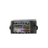
Garmin GPSMAP 4208 Chartplotter
Negotiable
MOQ: 11 Pieces (Price negotiable depending on order volume and customization)
Key Specifications
Get Latest Price
Brand Name:
Garmin
Place of Origin:
China
Model Number:
Payment & Shipping
Payment Methods:
Port of Shipment:
China
Delivery Detail:
7 days
Related Products
-
 Furuno 1715 LCD Radar SystemNegotiableMOQ: 11 Pieces
 -
Garmin GPSMAP 4212 ChartplotterNegotiableMOQ: 11 Pieces
-
Simrad NSS8 Touch Display Sonar/GPS ComboNegotiableMOQ: 11 Pieces
-
Humminbird Fishfinder 570 DI Portable SonarNegotiableMOQ: 11 Pieces
-
Humminbird 345 Color SonarNegotiableMOQ: 11 Pieces
Brand Name
Garmin
Place of Origin
China
- Video-quality resolution on a 8.4" VGA display
- Device-linking Garmin Marine Network compatibility
- Pre-loaded with richly detailed BlueChart g2 marine maps
- High-speed processor for fast map draws
- Intuitive interface for easy operation
- Supports ship-tracking AIS system
This sleek, feature-packed chartplotter delivers video-quality resolution on a 8.4" VGA display and the device-linking capability of the Garmin Marine Network. It’s pre-loaded with richly rendered BlueChart g2 marine maps of the United States – including Alaska, Hawaii and the Bahamas. BlueChart g2 maps provide detailed, high-definition views of coastlines, shaded depth contours, navaids, port plans, wrecks, restricted areas, and vital tide and current information. A high-speed processor also offers fast map draws and a intuitive interface that makes navigating and programming easy. Garmin Marine Network connectivity lets you network sonar, radar, weather sensors and other chartplotters to your 4208 Chartplotter for one-look access to all essential data. SD™ card compatible for adding memory or upgrading BlueChart g2 Vision 3D maps (sold separately). Stores up to 1,500 waypoints, favorites or locations, and up to 20 navigation routes. Track logs stores up to 10,000 points and 20 saved tracks. Supports ship-tracking AIS system and position data for DSC-capable VHF radios. Pre-loaded tide tables and solunar information. Audible alarms. AV input/output. Fully waterproof construction with external antenna. Includes flush mount, ball mount, GPS 17x NMEW 2000, power cable, NMEA 0183 cable, video cable assembly, marine grommet kit, protective front cover, owner’s manual and installation instructions.
Unit dimensions: 7"H x 11.2"W x 4.6"D.
Display dimensions: 5.2"H x 6.9"W, 8.4" diagonal.
Display resolution: 640 x 480 pixels.
Weight: 5 lbs.
Includes:
Unit dimensions: 7"H x 11.2"W x 4.6"D.
Display dimensions: 5.2"H x 6.9"W, 8.4" diagonal.
Display resolution: 640 x 480 pixels.
Weight: 5 lbs.
Includes:
- GPSMAP 4208
- Flush mount
- Bail mount
- GPS 17x NMEA 2000
- Power cable
- NMEA 0183 cable
- Video cable assembly
- Marine grommet kit
- Protective front cover
- Owner’s manual
- Installation instructions

Send Inquiry to This Supplier

* Email
Want the best price?
Post an RFQ now!
Business Type
Trading Company
Total Employees
101 - 200 People
Main Markets
North America, South America, Eastern Europe
Location
Rizhao, Shandong, China
You May Also Like
-
Original SMC IP200-120 Cylinder Positioner New Original AuthenticNegotiableMOQ: 1 Piece
-
GPS NavigatorNegotiableMOQ: 2500 Pieces
-
Alarm Monitoring Center Software for Navigation & GPSUS$ 5 - 55MOQ: 1 Piece
-
Analog Capacitive Level Sensor With Stainless Steel ProbeUS$ 40 - 80MOQ: 1 Piece
-
RION-BD982 High Positioning Accuracy GPS Navigation,Can Provide Position Information of Carrier (longitude, Latitude, Height)...NegotiableMOQ: 1 Set
-
GPS+GSM (850/900/1800/1900/2100MHz) / 3dBi GSM, 28dBi GPS Gain GSM/GPS AntennaUS$ 3.5 - 4.5MOQ: 10 Pieces
-
Speed Governor 3098693US$ 1 - 90MOQ: 1 Piece
-
Gps Tracker Key Chain Gps TrackerUS$ 1 - 3MOQ: 500 Pieces
-
Child Aviation Restraint System for Airplane TravelEUR 3 - 7MOQ: 200 Pieces
-
Globalsat BU-353 BU353 Android Tablet USB GPS Receiver Linux SIRF III Navigation Micro USB GPS Receiver BlackUS$ 1 - 100MOQ: 100 Pieces

