


Reflectorless Upward Laser Pointing Total Station
- 100 Set / Sets per Month
- Chongqing China
- T/T

You May Like
-
 Compact, Lightweight Design High Stability Total Station
-
Dual Axis Compensation Long Distance Surveying Total Station
-
Multi-constellation Tracking Lightweight RTK GPS Surveying System
-
Compact RTK GPS System With High Quality Positioning Performance
-
Hi-tech Smart RTK GNSS Instrument For Civil Engineering
-
High Surveying Stability Robotic Total Station
Product Details
| Place of Origin | Chongqing, China | Brand Name | Hi-target | |
| Model Number | ZTS360 (R) |
Product Description
Reflectorless Upward Laser Pointing Total Station
1. Mineral survey, exploration and excavation;
2. Construction of railways, highways, Bridges;
3. Irrigation and water conservancy, urban planning and construction;
4. The battlefield preparation, harbor, fortress, airports and military engineering construction;
5. Precision positioning and installation in shipbuilding and aerospace industry ;
6. The three-dimensional coordinates, the location of measurement, pipeline orientation, cross section measurement of the stuctures;
7. The triangle control survey, topographic survey, cadastral and property measurement.
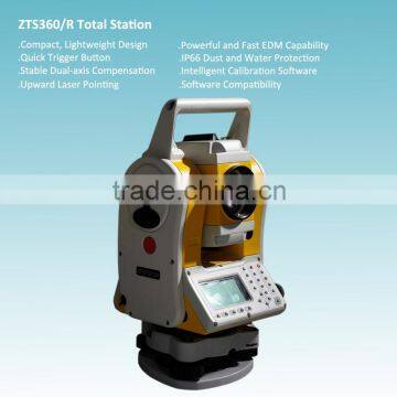
Compact, Lightweight Design
Rugged, compact design ensures the stability of every indicators of equipment and protect you from data loss on the harsh conditions.
Small size and light weight body make your work easily.
Quick Trigger Button
Measurement and record by pressing one quick trigger button, fast and convenient.
Stable Dual-axis Compensation
Simultaneous tilt compensation from horizontal and vertical angle makes sure the accurate measuring result, even when the body is rotating.
Vivid graphic electronic bubble display is available.
Upward Laser Pointing
Deviation from centre handle design makes upward laser pointing fast and easy, and no dead angle exists in upward measurement, which is significant for mining or tunneling application.
Powerful and Fast EDM Capability
600m Non-prism ranging.
Fine 0.8s, Track 0.3s in prism mode.
IP66 Dust and Water Protection
High standard IP66 performance provide protection from dust penetration and water driving.
Intelligent Calibration Software
The proprietary HI-TARGET Calibration software is accessible for real-time diagnosis to ensure trouble-free operation.
Software Compatibility
Compatible to the 3rd party data processing software, satisfying users’ requirements for different data format.
Angle measurement (Hz,V)
Detecting system——Absolute encoder
Minimum display——1″/5″/10″(selectable)
Accuracy——2″
Telescope
Magnification——30X
Field of view——1°30′
Minimum focus distance——1.5m
Image——Erect
Compensation
System——Dual-axis
Range——±3′
Resolving power——1″
Distance measurement (IR)
Single prism (good condition)——3000m
Reflective sheet——800m
Accuracy——2mm±2ppm
Measuring time (Repete/Tracking)——1s/0.5s
Reflectorless (RL)
Range (white board reflectivity 90%)——600m
Single prism——>7500m
Accuracy——3mm±2ppm
Measuring time——1.5s
Communication
Internal memory——20000 points (SD card supported)
Interface——RS232, Mini-USB, USB
Data format——ASCII
Operation
Operation system——Real-time operation system
Display——192×96 high-light LED screen, brightness adjustable in 3 level
Keyboard——2 sides alphanumeric backlit crystal keyboard
Laser plummet
Type——Laser point, 4 brightness levels adjustable (Optical plummet is optional)
Accuracy——1mm at 1.5m instrument height
Environmental
meteorological parameter modification——Manually(T-P senser is optional)
Operation temperature——-20℃_+50℃
Storage temperature——-40℃_+70℃
Dust & Water proof——IP66
Power supply
Battery type——BT30 Li-ion battery
Voltage/Capacity——7.4V 3400mAh
Operating time——18 hours(continuous angle measurement every 30 seconds)
Measuring times——Approx. 12000 times
Weight
Weight——3.8kg with battery
Characters
Zenith point measurement without removing the handle
Shortcut measurement key on the side, convenient for surveying
Small and light.
Key define
Intelligent checking
If you got any question, please feel free to contact:
Contact Us
- Chongqing Huobo Surveying Instruments Co., Ltd.
- Contact nameMichelle Li Chat Now
- Phone0086-023-62794421
- AddressNo. 7-8, No. 23, Nanping West Road, Nanping Street
Product Categories
| Drilling Rig | Mapping GIS | New Products | Surveying |
New Products
-
Compact Absolute Encoding Total Station For Land Surveying
-
Long Surveying Range Electronic Total Station
-
High-precise Positioning Geodetic Surveying RTK GPS System
-
Advanced RTK GNSS Surveying System With Professional Post-process Software
-
High-performance RTK GPS System For Field Surveying
-
Intelligent Calibration Software Applied Absolute Encoding Total Station
-
Absolute Encoding Upward Laser Pointing Total Station
-
Compact, Lightweight Design Absolute Encoding Total Station
-
Dual Axis Compensation Absolute Encoding Total Station
-
Microsoft Windows Mobile 6.5 operating system Hi-Target Qmini MP Field Controller
-
Full Satellites Singal Simultaneously Tracked RTK GPS Survey System
-
Professional Millimeter Level High Precision RTK GPS Survey System
-
Multi-satellite Millimeter Level RTK Surveying And Mapping Instrument
-
High Precision RTK GNSS Instrument For Topographic Surveying
-
Civil Land Surveying Design RTK GPS System
-
Multi-constellation Tracking RTK GPS Surveying System
-
High Precision RTK GPS Land Surveying System
-
Multi Satellite Signal Receiving RTK GNSS System
-
220 Channels Dual Frequency RTK GPS Surveying System
-
Topographic Differential Signal Receiving RTK GPS System
-
High Accuracy GNSS RTK System With Competitive Price
-
High Accuracy Dual Frequency GNSS RTK System
-
GPS model dual frequency H32 GNSS RTK GPS for Sale
-
Special design cheap and fine H32 RTK GPS with CE certification
Popular Searches
- digital theodolite
- Optical Theodolite
- Barcode Staff
- total station surveying instruments
- Survey Instruments Theodolite
- electronic theodolite
- Gps Surveying Instrument
- total station reflectorless
- station surveying
- Survey Equipment Theodolite
- Surveying Equipment Instrument
- high precision surveying instrument
- pixel mapping
- optical total stations
- Robotic Station
- Total Station Non Prism
- laser light with tripod
- Operating Station
- As Calculate Gps
- At Calculate Gps
- Be Calculate Gps
- Battery Total Set
- Batteries Total Set
- Calculate Gps
- System Station
- digit compensator
- digit compensators
- digit targeting
- dady
- dadi
Recommended Products
- South Total Station N40/ NTS 342R15B with Color screen Surveying Instruments With High Accuracy 2'' for land surveying
- SOUTH DSZ2/DSZ3 Auto Level Specialized Automatic Level Surveying32X auto level
- Cost-effective SOUTH N3/NTS-332R15M Total Station with Trigger key 2'' Accuracy Land Surveying instrument total station
- South 1500M Non-Prism Range 2'' Angle Accuracy Nts-332R10/Nts-332r15b/ Nts-332r110mTotal Station
- high-precision Factory direct sale Reliable quality digital theodolite prices
- hot sell model total station price
- high-precision Quality assurance high configuration electronic optical theodolite price
- china best price total station
- Hot Sell station total
- High technology durable high quality digital electronic theodolite
- Factory manufacture good quality high configuration cheap theodolite
- Professional manufacturer high precision cheap vernier theodolite
Find Similar Products By Category
- Instruments & Meters > Optical Lens & Instrument > Theodolite
- Please Enter your Email Address
- Please enter the content for your inquiry.
We will find the most reliable suppliers for you according to your description.
Send Now-
 Michelle Li
Welcome to my shop, I'm glad to serve you. Please feel free to send me any questions you may have.
Michelle Li
Welcome to my shop, I'm glad to serve you. Please feel free to send me any questions you may have.
Your message has exceeded the limit.
- Contact supplier for lowest price
- Customized Request
- Request Sample
- Request Free Catalogs
Your message has exceeded the limit.
-
Purchase Quantity
-
*Sourcing Details
Your inquiry content must be between 10 to 5000 characters.
-
*Email
Please enter Your valid email address.
-
Mobile