

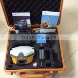
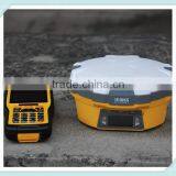
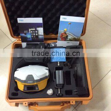
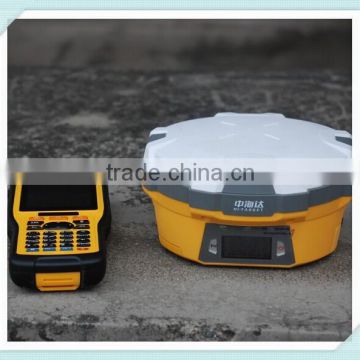
Surveying and Mapping High Accuracy Geodetic Equipment Hi-Target V60 GPS RTK Survey
Related Products
-
 Hi-Target V60 GPS RTK 220 Channel Tracking GNSS ReceiverUS$ 0.1 - 0.2MOQ: 1 Set
 -
High Quality Dual-frequency GPS WIFI Surveying Hi-Target V60 GPS RTK SystemUS$ 0.1 - 0.2MOQ: 1 Set
-
GPS GLONSS Receiver RTK System for Land Survey and Geodetic SurveyUS$ 0.1 - 0.2MOQ: 1 Set
-
DUAL FREQUENCY H32 GNSS RTK HI TARGET GPS RTK Topographic EquipmentUS$ 0.1 - 0.2MOQ: 1 Set
-
V30 GPS+GLONSS+ BDS High Positioning Accuracy and Stable Working PerformanceUS$ 0.1 - 0.2MOQ: 1 Set
2015 New Release GPS GNSS RTK Base or Rover V60 Surveying Instrument
Main Feature:
1. 9G20 400MHz CPU, embedded Linux OS to support faster data transmission
2. Equipped with smart speaker guiding and Industrial LED display screen, One- button operations for Intelligent Operation.
3. Static data can be saved directly in RINEX format
4.Supports GPS, GLONASS, GALILEO, BDS, SBAS.
5. High power transceiver UHF radio,HI-TARGET internal UHF radio and 2 watts (Max.)Pacific Crest micro XDL internal UHF radio are optional.
6.Seamlessly Operation in CORS System
7.Long-life Battery and IP67 Rugged Design
Technical Parameters | ||||
|
Measurements |
220 tracking channels |
|||
Advanced Pacific Crest Maxwell 6 Custom Survey GNSS Technology | ||||
High precision multiple correlator for GNSS pseudo range measurements | ||||
Unfiltered, unsmoothed pseudo range measurements data for low noise, low multipath error, low time domain correlation and high dynamic response | ||||
Very low noise GNSS carrier phase measurements with <1 mm precision in a 1 Hz bandwidth | ||||
Signal-to-Noise ratios reported in dB-Hz | ||||
Proven Pacific Crest low elevation tracking technology | ||||
|
Satellite signals tracked simultaneously |
GPS: Simultaneous L1C/A, L2C, L2E, L5 |
|||
GLONASS: Simultaneous L1C/A, L1P, L2C/A (GLONASS M only), L2P | ||||
SBAS: Simultaneous L1 C/A, L5 | ||||
Galileo: Simultaneous L1 BOC, E5A, E5B, E5AltBOC | ||||
BDS: B1, B2 | ||||
QZSS: L1 C/A, L1 SAIF, L2C, L5 | ||||
|
Positioning Accuracy |
Static and Fast Static GNSS surveying |
Horizontal: 2.5mm+0.5ppm RMS
Vertical: 5mm+0.5ppm RMS |
||
Stop & Go GNSS surveying |
Horizontal: 1cm+1ppm RMS Vertical: 2.5cm+1ppm RMS Initialization time: typically 10 minutes for base while 5 minutes for rover Initialization reliability: typically > 99.9% |
|||
Realtime Kinematic(RTK) surveying |
Horizontal: 8mm+1ppm RMS Vertical: 15mm+1ppm RMS Initialization time: typically < 8 seconds Initialization reliability: typically > 99.9% |
|||
|
Code Differential GNSS positioning |
Horizontal: 25cm+1ppm RMS
Vertical: 50cm+1ppm RMS
SBAS[iv]:0.50mHorizontal,0.85m Vertical |
||
|
Hardware
|
Physical |
1.Dimensions (W x H): 18.20cm x 9.80cm(7.17 in x 3.86 in)
2.Weight: 1.25kg (2.76lb) with internal battery, internal radio, standard UHF antenna
3.Operating temperature: -45℃to +65℃ (-49℉ to +149℉)
4.Storage temperature: -55℃ to +85℃ (-67℉ to +185℉)
5.Humidity: 100%, considering
6.Water/dustproof: IP67 dustproof, protected from temporary
7.immersion to depth of 1m (3.28ft).
8.Shock and Vibration: Designed to survive a 3m(9.84ft) natural fall onto concrete.
9. Storage: 1GB Internal storage+ 8GB Internal Micro SD Card memory (Support up to 32GB extension) |
||
|
Electrical |
1.Power 6V to 28V DC external power input
2.Power consumption 3.5W
3.Automatic Switching between internal power and external power
4.Rechargeable, removable 7.4V, 5000mAh Lithium-Ion battery in internal battery compartment
5.Internal battery life, Static 13 - 15 hours, RTK Rover (UHF/GPRS/3G) 10 - 12 hours and RTK Base 8 - 10 hours
|
|||
|
Communication
|
3G Communication |
Fully integrated, fully sealed internal GPRS/GSM or 3G Network RTK (via CORS) range20-50km |
|
HI-TARGET internal UHF radio (standard) |
Frequency: 450-470 MHz with 116 channels
Transmitting Power: 1W, 2W, 5W adjustable
Transmitting Speed: Up to 19.2Kbps
Working Range: 3~5Km typical, 8~10km optimal |
||
|
PacificCrest XDL micro Internal UHF Radio (Optional) |
Frequency: 403~473 MHz
Transmitting Power: 0.5W, 1.0W, 2.0W adjustable
Transmitting Speed: Up to 19.2Kbps
Support most of radio communication protocol Working Range: 3~5km typical, 8~10km optimal |
||
HI-TARGET External UHF radio (standard) |
Frequency: 460 MHz with 116 channels
Transmitting Power: 5W, 10W, 20W, 30W adjustable
Transmitting Speed: Up to 19.2Kbps
Working Range: 8~10Km typical, 15~20km optimal |
||
|
Pacific Crest ADL Vantage Pro External UHF radio (Optional) |
Frequency: 390~430 MHz or 430~470 MHz
Transmitting Power: 4W to 35W adjustable
Transmitting Speed: Up to 19.2Kbps
Support most of radio communication protocol
Working Range: 8~10Km typical, 15~20km optimal |
||

Send Inquiry to This Supplier

You May Also Like
-
River Flow Measurement Ultrasonic Open Channel Flow MeterNegotiableMOQ: 100 Units
-
221824054 Heavy Duty Truck Sensor Parts Fuel Tank Level Sensor For DAFNegotiableMOQ: 1
-
Water Level Gauge UHZ-99A Magnetic Water Level Gauge RS485US$ 149 - 499MOQ: 1 Piece
-
50CM Aluminum Levels (0.7-1 mm THICKNESSUS$ 1 - 30MOQ: 600 Pieces
-
Aluminium Spirit Level in Stock,Levelling Instrument Measure Toolsin Stock,high Quality Spirit Level in Stock SL0001US$ 3.2 - 4.5MOQ: 500 Pieces
-
Gsm Modbus Rtu for M2M Gsm Gprs Monitor M3G6 Data LoggerUS$ 80 - 150MOQ: 1 Piece
-
Liquid Level Float Switch/ Pull-in Type Water Float SwitchUS$ 6.5 - 8.1MOQ: 20 Pieces
-
DMI820 Digital Output Inclinometer/TIlt Sensor/TIlt Meter With 2.8" Touch Screen High Accuracy0.003 Within Full Measuring RangeNegotiableMOQ: 1 Piece
-
Submersible 4-20ma Level TransmitterUS$ 80 - 200MOQ: 1 Unit
-
Tank Pool Water Tank Level Switch Liquid Sensor Float Switch New Water Level Controller Float SwitchUS$ 1 - 100MOQ: 100 Pieces


