

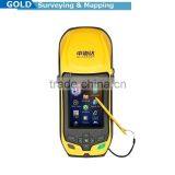
CM Level Accuracy Handheld Mapping RTK GIS


Related Products
-
 Qstar 8 High Precision RTK Handheld Mobile GPSUS$ 5.00 - 5.00MOQ: 1 Set
 -
High Precision Handheld RTK GPS InstrumentUS$ 5.00 - 5.00MOQ: 1 Set
-
Level Measuring Handheld GIS GPS InstrumentUS$ 5.00 - 5.00MOQ: 1 Set
-
High Precision Handheld GPS NavigatorUS$ 5.00 - 5.00MOQ: 1 Set
-
Top Quality High Accuracy GIS Data CollectorUS$ 5.00 - 5.00MOQ: 1 Set
CM Level Accuracy Handheld Mapping RTK GIS
Qstar mapping rtk gis is the best platform of application software for high accuracy GIS data collection and it is widely applied to power line inspection, land & resources management, forestry, agriculture, piping, underground cabling, waste water management and so on.
1. Dual-frequency
2. Lightweight and rugged design, IP67
3. Handheld cm-level real time accuracy
4. Embedded 3G communication module
5. OS Microsoft Windows Mobile 6.5
6. Outstanding GPS&GLONASS performance
7. Versatile handheld for surveys and GIS jobs
GNSS features:
1. 120 Channels
2. Proven NovAtel GNSS technology
3. Multipath mitigating technology
4. Auxiliary strobe signals, including a configurable output for time synchronization and mark inputs.
Satellite signals tracked simultaneously
GPS: L1, L2, L2C; GLONASS: L1, L2; Galileo: E1
GIOVE-A/GIOVE-B (test); BDS/Compass
SBAS; QZSS
Positioning performance
Time for the first fix (TTFF): 30S
Update rate: 1Hz (support higher frequency)
Single point positioning: 2m
Static and Fast static
Horizontal: 5mm + 0.5ppm RMS
Vertical: 10mm + 0.5ppm RMS
Post processing kinematic (RTK/Stop & Go)
Horizontal: 1cm + 1ppm RMS
Vertical: 2.5cm + 1ppm RMS
Initialization time: typically < 8 seconds
Initialization reliability: typical > 99.9%
Real time kinematic (RTK)
Horizontal: 10mm + 1ppm RMS
Vertical: 20mm + 1ppm RMS
Initialization time: typically < 8 seconds
Initialization reliability: typical > 99.9%
Code differential GNSS positioning
Horizontal: 25cm + 1ppm RMS
Vertical: 50cm + 1ppm RMS
SBAS: 0.5m Horizontal, 0.85m Vertical
Processor Frequency
806MHz
Operation system
Microsoft Windows Mobile 6.5 professional
Cellular
Built-in GPRS/3G modem
Band
1. HSDPA/UMTS 2100/900 MHz(adjustable)
2. EDGE/GPRS/GSM 1900/1800/900/850 MHz
Other
Wireless LAN: 802.11bg
Bluetooth: Bluetooth 2.0
Mini USB 2.0
If you got any question, please feel free to contact:

Send Inquiry to This Supplier

You May Also Like
-
Original SMC IP200-120 Cylinder Positioner New Original AuthenticNegotiableMOQ: 1 Piece
-
GPS NavigatorNegotiableMOQ: 2500 Pieces
-
Alarm Monitoring Center Software for Navigation & GPSUS$ 5 - 55MOQ: 1 Piece
-
Analog Capacitive Level Sensor With Stainless Steel ProbeUS$ 40 - 80MOQ: 1 Piece
-
RION-BD982 High Positioning Accuracy GPS Navigation,Can Provide Position Information of Carrier (longitude, Latitude, Height)...NegotiableMOQ: 1 Set
-
GPS+GSM (850/900/1800/1900/2100MHz) / 3dBi GSM, 28dBi GPS Gain GSM/GPS AntennaUS$ 3.5 - 4.5MOQ: 10 Pieces
-
Speed Governor 3098693US$ 1 - 90MOQ: 1 Piece
-
Gps Tracker Key Chain Gps TrackerUS$ 1 - 3MOQ: 500 Pieces
-
Child Aviation Restraint System for Airplane TravelEUR 3 - 7MOQ: 200 Pieces
-
Globalsat BU-353 BU353 Android Tablet USB GPS Receiver Linux SIRF III Navigation Micro USB GPS Receiver BlackUS$ 1 - 100MOQ: 100 Pieces

