

Topcon Cheaper TopSURV Field Controller Software


Related Products
-
 Leica GEV215 Instrumentation CableNegotiableMOQ: 5 Pieces
 -
TrimbleBD970NegotiableMOQ: 1
-
Trimble Dual-frequency RTK GPS Receiver on a Sigle Compact Card BD950NegotiableMOQ: 1 Unit
-
Used Thales/Ashtech/Magellan Z-Max GPS System Receiver With 12 ChannelNegotiableMOQ: 1 Set
-
Leica GEB212 Rechargeable Li-ion BatteryNegotiableMOQ: 1 Piece
Specifications
Topcon TopSURV field controller softwareCheaper
We provide the registier code for you.
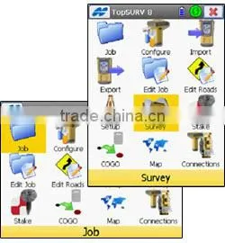
TopSURV 8
Field controller software with a superior graphical user interface and fast performance
|
See everything clearer. Of the many features in the new TopSURV 8, the large graphical user interface (GUI) is one of the best. With the big icons you can point and touch with your finger, instead using a stylus. Portrait and landscape devices supported. Survey with speed and convenience. Create, edit, upload, and download faster using advanced data management techniques. How many instruments do you use on the jobsite? To simplify your work, Topcon stores configuration files for each instrument. Switching from a GRS-1 to a QS is a snap — there’s no wasted time configuring baud rates and connection settings. Just do it once and store it. Compatibility problems? We know there are several programs that require specific file formats, so we’ve given TopSURV 8 numerous file formatting export options. |
|
Features include:
- Single Source Solution
- Intuitive User Interface
- Graphical Topography and Stakeout
- Real Time Field to Finish
- Advanced Roading
- Real-Time Roads™
- Industry leading Road Staking
- Customizable Stake Reports
- Vast library of Import / Export formats
|
Intuitive User Interface TopSURV 8 maintains the familiar large icon menu structure for fast and easy touch navigation. Portrait and landscape devices supported. |
|
|
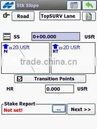
Stakeout Transition Points The opening dialog of the Road and Slope stakeout routines now offers options for stopping at various Transition Points along the design, for both horizonatal and vertical critical stations. |
|
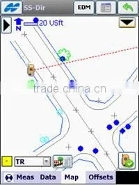
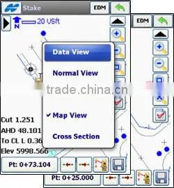
MAP-based Topography TopSURV 8 provides a superior MAP view in Topo that allows the user to measure and code while showing their current position in real-time. More Viewable MAP Area By adding callapsable toolbars for status, robotic icons, and zoom icons, the TopSURV 8 map provides more viewable area. |
|
|
User-defined Stakeout Interface Stakeout now supports up to five different views for the graphical information that is displayed. Additonal customization can be done through user-defined data labels. Simply click on the data label to select from the data label options list. |
|
Two Surface Volumes TopSURV 8 allows the user to store a measured surface while staking a DTM, and provides the ability to calculate two surface volumes in COGO. |
|
|
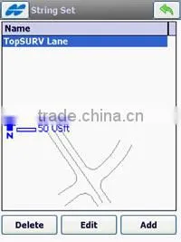
Road Strings Road Strings and the ability to define String Sets that define the true road design surface sets TopSURV apart from products limited to cross section road staking. |
Modules Available:
TopSURV Basic - Core Package that includes communication interfaces to optical total stations, levels, and GIS handheld data collectors for DGPS.
TopSURV Robotic - Take control of your Topcon robotic instrument, with complete support for all of the advanced features of our full robotic line-up!
TopSURV GPS+ - Unleash the full power and capability of your Topcon GPS+ system!
TopSURV Pro (Roading) - Create & edit cross section templates, string sets, horizontal and vertical alignments. Survey using cross sections, calculate using road alignments, and stakeout roads & slopes. Real-Time Roads(TM) brings high production to road staking.
TopSURV Millimeter GPS+ - Control your Topcon Millimeter GPS+ system using TopSURV.

Send Inquiry to This Supplier

You May Also Like
-
KING PIGEON Alarm Access Network Controller , Contact id Alarm Monitoring SoftwareUS$ 5 - 55MOQ: 1 Piece
-
Bridge Crane Operator Training and Exam System, Vocational Education, Operation Training Equipment, Bridge Crane SimulatorUS$ 10,000 - 20,000MOQ: 1 Set
-
Computer Classroom Management SoftwareUS$ 200 - 2,000MOQ: 1 Set
-
Durable Sandwich Panel Wall Storage Tents for SaleUS$ 20 - 60MOQ: 1 Set
-
Scanning and Packing Management SoftwareNegotiableMOQ: 0 Set
-
Zwsoft Agent, Zwsoft 3dNegotiableMOQ: 0 Set
-
Office 365 E5 Enterprise 1 Year 200users License KeyNegotiableMOQ: 10 Pieces
-
[hunan Chuang'an Explosion-proof] Ema-12 Electric Energy Metering and Analysis SystemNegotiableMOQ: 0 Set
-
TI Studio Mobile ClientNegotiableMOQ: 1 Piece
-
Intelligent Trane Repair Assistant: Accurate Diagnosis, Efficient MaintenanceCNY 11000 - 13000MOQ: 1 Piece


