

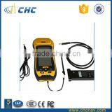
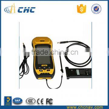
CHC LT500T Handheld Gps Geophysical Equipment Gis Mapping


Related Products
-
 CHC LT500T High Precision GIS Data CollectorUS$ 4,000 - 5,000MOQ: 1 Unit
 -
CHC LT500T Handheld Gps Geological Survey Instrument Touch ScreenUS$ 4,000 - 5,000MOQ: 1 Unit
-
CHC X91+ Rugged Geological Survey Instrument Price Gnss ReceiverUS$ 8,500 - 11,000MOQ: 1 Piece
-
CHC LT500N Handheld Gps Survey Equipment Gps for Land SurveyUS$ 2,500 - 3,800MOQ: 1 Unit
-
CHC LT500N Handheld Gps Survey Equipment Geological Survey InstrumentUS$ 2,500 - 3,800MOQ: 1 Unit
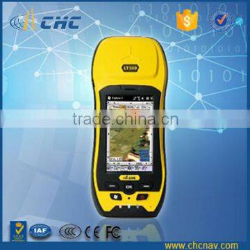
CHC LT500T handheld gps geophysical equipment gis mapping
handheld gps
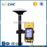
The LT500 series is a rugged, versatile GNSS handheld receiver, that LT500N/LT500T/LT500H covers three
accuracy ranges from submeter to centimeter accuracy and is the most cost effective positioning solution for
Survey, Construction and GIS professionals.
| LT500T GNSS (DM Level) | 220 Channel L1 GPS+GLO+BDS | ||
| Part Number | Description | Pcs |
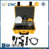
| LT500T Kit | ||
| 0505 120 005 | LT500T Kit | 1 |
| 1250 341 222 | LT500T GNSS Receiver | 1 |
| 0406 000 041 | Carry Pouch | 1 |
| 0403 000 083 | Data Cable | 1 |
| 0405 000 063 | Li-ion battery | 1 |
| 0405 000 099 | Power Adapter | 1 |
| 0103 020 183 | Stylus | 1 |
| Software | ||
| 0408 000 008 | SurvCE GPS Only Data Collection Software | 1 |
| 0408 000 021 | DigiTerra Professional Software | 1 |
LT500H L1/L2 GPS+GLONASS, L1 BDS, L1 Galileo Tracking
The LT500H addresses a centimeter level position accuracy utilizing the internal cellular modem to access a local reference station network under RTK working mode.
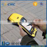
LT500T L1 GPS+GLONASS+BDS+Galileo
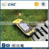
The LT500T is designed to work in the projects requiring the decimeter accuracy, in the application as utilities, underground pipelines and land records management when high accuracy is required.d gps
LT500N L1 GPS
Embedded with professional GPS engine, the LT500N prepares the user to capture submeter data with SBAS differential correction signals or DGPS correction information from the local reference station.
Productive sensors
User productivity is greatly enhanced with the builtin gyroscope, an innovative laser plummet for positioning the accurate handheld receiver over a point, an Ecompass for showing the direction and a Gsensors for leveling. Optional RFID and 1D/2D bar code scanners help automate complex inventory tasks.
Stay connected
Builtin standard 3.5G cellular modem and WiFi keep you connected to RTK corrections' networks and provide seamless internet access. Bluetooth is available for connection with other hardware such as laser range finder, underground pipeline locator.
KEY FEATURES
|
|
|
|
|
|
CHC Navigation are dedicated to providing reliable and competitive GNSS solutions with high performance. Most of CHC products have achieved IP67 dustproof and waterproof level.
| Type | LT500H | LT500T | LT500N |
| Channel | 120 | 220 | 12 |
| Satellite Signals | GPS: L1, L2. GLONASS: L1, |
GPS: L1 GLONASS: L1. |
GPS: L1 |
| Update Rate | 1 Hz, or higher | 1 Hz, or higher | 1 Hz, or higher |
| Protocols | RTCM2.x/RTCM3.x |
RTCM2.x/RTCM3.x |
RTCM2.x |
| Cold Start | < 50s | < 45s | < 60s |
| Hot Start | < 35s | < 30s | < 30s |
| Reacquisition | < 1s | < 2s | < 1s |
| Stand alone GPS | 1.2m | 2m | 2.5m |
| Realtime Correction | 1cm | 25cm | 60cm |
| With SBAS | 50cm | 50cm | 1m |
| Real-time Correction | Horizontal: 1cm |
Horizontal: 25cm |
Horizontal: 60cm |
| Post Processing Static | Horizontal: 5 mm ± 1 ppm |
Horizontal: 5 mm ± 1 ppm |
Horizontal: 5 mm ± 1 ppm |
|
System Configuration |
· Windows® Embedded Handheld 6.5 operation system · Processor: 1 GHz · Memory · 5.0 megapixel camera with autofocus |
| Display |
· 4.3” sunlight readable screen · Resolution: WVGA 480 X 800 pixel |
Communications |
· Cellular Modem · Bluetooth: 2.1 + EDR · WiFi: 802.11 b/g · USB Port |
Physical |
· Size (LxWxH): 236 x 97 x 77 mm (9.3 x 3.8 x 3.0 in) · Weight: 897 g with battery (31.6 oz) · Operating temperature: -30 °C to 70 °C (-22°F to 158 °F) · Storage temperature: -40 °C to 80 °C (-40°F to 176 °F) · Dust proof and waterproof: IP67 · Shock: survives a 1.2meter drop on to concrete |
Electrical |
· Li-ion battery capacity: 11.1V, 2600 mAh · Battery life: up to 13 hours (Autonomous GNSS usage) · Charging time: 4 hours (typical) |
Sensors |
· Gyroscope · Laser plummet · Ecompass · Gsensor · RFID(optional) · 1D and 2D bar code scanner(optional) |
handheld gps
CHC provides the most reliable packaging to perfectly protect the equipment from transportation damages.
Rugged design helps you to work in kind of hursh environment. handheld gps
No matter it is traditional survey work or GIS work, the built in high performance GNSS models makes your work more efficeint and easy.
CHC has the latest production facilities, professional production lines and strict testing requirement to make sure
every device on your hands is with good quality and can be trusted.
Founded in 2003, CHC designs, manufactures and markets a wide range of professional GPS/GNSS solutions in more than 100 countries. Headquartered in Shanghai (China) and with offices worldwide CHC is a leading GNSS manufacturer with a strong international presence and employs more than 800 professionals worldwide.
Exhibition & Seminar
handheld g
Q: What is the Payment Terms?
A: T/T in advance.
Q: How about the Shipping Date?
A: Normally within 7 working days after payment received.
Q: How about the after-sales service?
A: We have Technical on-line Support Team that will respond any question you ask.
Q: How to buy this Product?
See below contact information. Or you're always welcomed to leave messages on our Alibaba Trade Manager.
Please feel free to contact us if you have any question. CHC will always dedicate the best service to you.
ps

Send Inquiry to This Supplier

You May Also Like
-
Endress+Hauser E+H Compact Conductivity Device Smartec CLD18-BGGENegotiableMOQ: 1 Piece
-
ISO 10113 Compliant Metallic Material Tensile R Value Testing Machine With Digital ReadoutUS$ 3000 - 20000MOQ: 1 Set
-
Hydraulic Plastic Flange Connections Cover Plugs SHF SeriesUS$ 0.22 - 0.28MOQ: 2500 Pieces
-
HST Spring Dyno Friction Leakage Fatigue Testing MachineUS$ 5000 - 10000MOQ: 1 Set
-
Gates 550C 550U U550 U-550 U508 U-508 Japan Unitta U-550 Belt Tension Meter New U-508 Belt Tension Meter Upgraded Version U550US$ 1 - 900MOQ: 1 Piece
-
Analytical Balanace.scale ,weichengya Laboratory SupplierUS$ 10 - 35MOQ: 10 Sets
-
Smart MD-3051 Online Density Meter With 4-20mA OutputUS$ 2,380 - 2,500MOQ: 1 Unit
-
5W-300W Sun Simulator Watt Testing 30% Off / Xenon Lamp Sun Simulator Free Sent / Sun Simulator TestingUS$ 7,500 - 10,000MOQ: 1 Set
-
New Design Measuring Meter With Best PerforanceUS$ 1,000 - 1,200MOQ: 1 Piece
-
XK-1 Rotary Switch Life TesterNegotiableMOQ: 1 Set


