Home > Products > Marine Electrical Equipment > High Quality Marine GPS Chart Plotter For Sale


High Quality Marine GPS Chart Plotter For Sale
- China Port
- T/T Credit Card
You May Like
Product Details
| Place of Origin | Chongqing, China | Model Number | 12 inches | |
cartons
Product Description
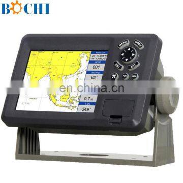
High Quality Marine GPS Chart Plotter For Sale
Features:
High resolution TFT day-view LCD display
SD-cards slot for C-Map MAX and user data
C-Map MAX and K-Chart Selectable
Tide table
Versatile display mode include
Plotter Screen
Nav.Data
Satellite Information
AIS Display
Compass Screen
GOTO track navigation
Map orientation select
Proximity waypoints alarms
Perspective View
Palette
Normal
Daylight – exposed to sunlight
Night – in dark environment
NOAA- paper chart colors
Spec:
PLOTTER CHARACTERISTICS | |
Waypoints/icons | 15,000 waypoints with name, symbol, 10 proximity waypoint |
Routes | waypoint up to 200 points each, plus MOB and Track Navigation or Goto Track modes |
Tracks | 30,000 point automatic track log; 15 saved track (up to 2000 track points each) let you retrace your path in both directions |
Alarms | XTE, Anchor drag, arrival, speed, voltage, proximity waypoint and time, AIS alarm. |
Pallete | 1 Normal 2 Daylight exposed to sunlight 3 Night in dark environment NOAA paperchart colors |
Tides | Tide data |
Projection | Mercator projection |
Position format | Lat/Lon |
Base map | Built-in Onwa K-Chart |
External Map | SD Cards slot for C-Map MAX |
User data storage | Internal backup of user settings, or external SD-card |
Plot Interval | 1s to 99h or 0.01 nm to 9.99nm |
Plotting scales | 0.01nm to 1,000nm |
Nav Data | Inputs: |
Perspective View | On/off |
POWER SUPPLY | 10.5 to 35VDC, current drain <600mA at 12V |
PHYSICAL | |
Size | 363.8mm(H)X267.9mm(W)X106mm(D) |
Weight | 3.95kg |
Display | 12.1-inches ColorTFT day-view LCD 800 X 600 pixels |
Waterproofing | Display unit: IPX5 |
Temperature range | Display unit: -15℃ to +55℃ |
GPS RECEIVER CHARACTERISTICS | |
Receiver | 50 parallel channel GPS receiver continuously Tracks and uses up to 50 satellites to compute and update your position |
Acquisition times | Cold start: 27 seconds average |
Update rate | 1/second,continuous |
Accuracy | Position: 2.5 meters(95%) without S/A |
Dynamics | Altitude: 50,000m Max |
Datum | WGS 84 & Others |
Interfaces | NMEA 0183 input and output,RS232 and RS422 output |
Antenna | KA07 |
AIS INTERFACE | |
Data input | NMEA 0183 , RS232 or RS422 |
Baud rate | 38,400 |
EQUIPMENT LIST | |
Display unit Antenna unit with 10m cable Operation manual Installation materials and standard spare parts | |

Company Profile

Contact Us
- Bochi Corporation
Product Categories
New Products
-
Marine Plastic Fish Finder Transducer
-
Marine Copper Fish Finder Transducer
-
Marine Fish Finder Detect Transducer
-
Class B Transponder AIS Buoy With CE
-
Marine GPS AIS Buoy For Fishing Boat
-
Marine AIS Buoy Tracking Device For Boat
-
Portable GPS AIS Buoy For Fishing Net
-
Marine Fishing Net For Sale
-
Wholesale 2015 New Waterproof AIS Buoy
-
Marine AIS Buoy Fishing Net With CE
-
XLPE Marine Electrical /Power Cable
-
Full SS Shell and Tube Heat Exchanger
Popular Searches
- pontoon
- salvage
- jet ski dock
- floating dock
- floating pontoon
- jet ski pontoon
- floating pontoon dock
- jet ski pontoon dock
- jet ski platform
- floating ball buoy
- steel ship
- marine airbag
- floating bridge
- marine mooring buoy
- marine rubber fender
- boat fender
- port rubber fender
- marine boat bumper
- dock rubber fender
- pneumatic rubber fender
- rubber balloon
- inland transportation
- inflatable floating dock
- inflatable air floating dock
- jetski dock
- marina
- floating jetty
- floating platform
- jetty
- boat dock
Find Similar Products By Category
- Industrial Equipment & Components > Engine & Part > Engine Parts
Bochi Corporation
- Please Enter your Email Address
- Please enter the content for your inquiry.
We will find the most reliable suppliers for you according to your description.
Send Now-
 sales
Hi there! Welcome to my shop. Let me know if you have any questions.
sales
Hi there! Welcome to my shop. Let me know if you have any questions.
Your message has exceeded the limit.
- Contact supplier for lowest price
- Customized Request
- Request Sample
- Request Free Catalogs
Your message has exceeded the limit.
-
Purchase Quantity
-
*Sourcing Details
Your inquiry content must be between 10 to 5000 characters.
-
*Email
Please enter Your valid email address.
-
Mobile